Monday 30 November 2020

CQ Worldwide CW Contest 2020 - 10m band at G4OBK

For the first time in some years and with a respectable sunspot count of over 100, I decided to enter a worldwide amateur radio contest - this is the annual CQ WW CW Contest which always takes place over the last weekend in November. CQ is an American Ham Radio magazine, so it comes as no surprise that the contest falls around the time of their Thansgiving Day Bank Holiday. It also happens around the time of my birthday - the 28th November - this time round I was 68 on the Saturday of the contest. With the current lockdown in England there was no better time to take part in a 48 hour contest - although I would only operate during daytime hours. 

When I was younger I would take part in most of the worldwide contests and try to stay awake and operate for the full 48 hours. This just isn't possible for various reasons now so an entry on the 10m band when there is propagation mostly during daylight seemed appropriate. So what equipment should I use? 

Ideally a dedicated antenna, such as a 5 element yagi built for the 10m band would be ideal, however this was not possible so I used my every day antenna - the multiband G3TXQ Hexbeam which on 10 metres is claimed by its maker MW0JZE to produce 3.6 dBd gain with a front to back ratio of 16 dB. The rotatable Hexbeam is fed with Ecoflex 15 coaxial cable and it is fixed at 12m above ground on a Tennamast. It is rotated above a 4m/6m yagi by a Yaesu G-1000DXC motor:


On the Saturday morning after opening my birthday cards and present from XYL Judy - a new jumper and fleece dressing gown, I ventured into the shack, however the 10m band in North East England was devoid of signals at 0830z - at 0848z though something started to happen and RN9S in EU Russia was the first station heard and worked.

Plenty more stations were worked immediately afterwards and within an hour of logging RN9S I had 20 stations in the log. Running by CQ Calls on a frequency proved pointless as I got few takers, even using 400 watts of power, so search and pounce was my best option. In the days previous to the contest I had downloaded and re-familarised myself with the contest logging program Super Duper by Paul O'Kane EI5DI. The program is easy to use compared to some of the newer contesting software - its heritage dating back to around 1990 when we were using DOS. Its not too complicated and after a gap of more than 10 years using it, with a little practice, I was up and running. I had the CAT connection and Winkey CW keying from my keyboard using the microHam CW Keyer and Bencher paddle key.  My station was the Yaesu FTDX101MP and Linear Amp UK Gemini DX1200 amplifier - having decided to run in the single band 10 metres, unassisted classic high power section of the contest.  I also used for the first time in a contest, my SDR Play RSP1A receiver displaying 28000 - 28060 KHZ on a seperate monitor. This proved very useful when the band opened up but was not so busy, as new CW activity could be seen on the spectrum display. The transceiver could then be put straight on to the frequency of interest to see if I had worked that call. As the band was relatively quiet all through Saturday the information provided by the extra SDR receiver proved to be a Godsend! 

Saturday proved to be the poorest day compared to Sunday, when I was able to run and work 65 stations in an hour - mostly from Eastern Europe and Russia. Among them was 4L6QL, a country and zone multiplier. My best 10 rate was 140 an hour, but this was short lived! Some of the sending speeds used by the serious stations were ridiculous, and to the untrained ear would not have been recognisable as Morse Code. The special callsign stations in Cyprus and Zone 33 were the worst culprits. I took a casual attitude to the contest and took a break when things were quiet, and an hour off for my lunch both days. On Sunday a two mile dog walk interupted my activity and I guessed that some USA stations were not worked that could have been.  

On the Saturday session the first USA station heard and worked was at 1425z. This was N4XD (Zone 5), this was just after working P40W in Aruba. Only five USA stations (all Zone 5) were worked on the Saturday and the opening finished with N4BP at 1433z!  N4BP was the most consistently heard and probably the loudest of the USA stations heard on both days. I must have tuned across his signals at least 10 times over both days and he was always the loudest. After USA faded out it was Caribbean and South America until 1625z when the band closed, but there lean pickings and I ended the day with 73 valid contacts, 33 countries and 14 zones. 


Sunday dawned and having lingered over breakfast I went into the shack around the same time to find 10 Metres coming to life at 0850z. This time R4GM was first into my log. Over the last 10 years contesting has changed somewhat - the one most noticable thing are the special shortened callsigns used by the seasoned contesters. Calls such as G3T, D1M, C4W, P3X etc. Years ago you would have taken these for pirate stations! The other noticable changed is the earlier mentioned sending speeds from programmed keyers wound up to ridiculous speeds of 40-50 WPM.  Propagation conditions on Sunday were better for sure, with a great opening to Eastern EU and Russia in the late morning - the spectrum display on the RSP1A was not needed as the band was full of big signals! More EU countries were logged via reflective propagation rather than direct path so that boosted the multipliers to some degree. Either side of the lunctime period some good DX worked such as 5T3, CX, ZD7, CE, KP3/4s, PJ4, 8Q7, TA, PZ5, C6, ZF and W (Zone 4 and 5). The only gotaway I heard and called for 15 minutes but which gotaway was VK3JA from around 0900-0915z. He had a long line of callers which I couldn't hear, but he didn't hear me!  At 1328z I worked C6AGU and then K1TTT but no other USA stations were apparent. I took an hour off to walk our dog, returning at 1424z to find several USA stations working at good strength in a far better opening than the previous day - 15 were logged, including Zone 4, with W4DD being the last USA station logged at 1550z. The only Canadian station logged was VO1HP in Newfoundland.


From then on it was South America only until the band was devoid of signals at the later time Sunday, of 1730z. My Cabrillo contest entry struggled with the callsign for AZ1A/X which was Argentina. What the /X stands for is not known. The contest organisers will hopefully allow me the 3 points for that one...
 
*In early December CQ Magazine released raw scores - at
present I am coming in at 5th in EU in the single op high power section:
I really enjoyed my time in the CQWW CW Contest this year, a refreshing change from the daily routine of SOTA Chasing and DXing using WSJT-X on FT8... My final claimed score was 208 QSOs with 50 countries and 19 zones for 26634 points. The only station I heard of any significance and did not work, was VK3JA who has a great ham radio station. Steve's QRZ.COM entry tells the story -  plenty of real estate and a Rhombic antenna centred on EU on a lovely hilltop QTH in Victoria. Maybe I'll work him next time...

73 Phil G4OBK

Result: #1 England #4 Europe (Up 1 place on claimed scores)


Sunday 11 October 2020

SOTA GM/SS-184 Middlefield Law and GM/SS-120 Cairn Table

With a good weather forecast on 11th October 2020 I left Pickering at 6.00am en route to the East Ayrshire town of Muirkirk which is close to the two summits for the day.

SS-184 Middlefield Law

It was exactly 200 miles to the parking place at NS685297 and I got there without having to stop. A really good drive on a sunny morning, minimum temperature 2c on the M74 in the shade and at the parking place near the metal gate by Forkings:


From here I followed the quad track - which veers off when near the summit. Quite a dry and steady walk up, not too steep with a few wet patches. It took me 24 minutes to reach the trig. As it was Sunday I expected plenty of chasers on 2m FM to be within range, and I wasn't dissapointed. After working regular chaser GM7NZI (Ray) I was called by MM7MMW/P (Michael) who was on SS-042 Shalloch on Minnoch - a very welcome S2S contact. 
©Crown copyright 2020 Ordnance Survey Media 010/20

Yaesu FT-1500M - 40 watts to an end fed dipole on an old broken pole on its last legs...

GM/SS-184 Middlefield Law
After eleven contacts on 2m FM in fifteen minutes I closed down and made my way back to the car.
 
SS-120 Cairn Table
As I parked the car on Furnace Lane on the opposite side of Muirkirk to Middlefield Law I heard MM0GOG/P (Duncan) calling CQ SOTA. He was strong so it was no surprise when he said he was on Cairn Table above me! I got my chaser points as GM4OBK/M and agreed that we would meet each other on my way up. It was time for an early lunch, so I had that in the car to save carrying it up to the summit. Whilst eating I heard Duncan working Pete MM0HQO/P on Green Hill SS-123 near Wanlockhead. Pete lives very close to me in Pickering, unfortunately as I was in the valley I couldn't hear him. The walkers car park was full but there is plenty of roadside parking in Furnace Lane across from the Muirkirk Golf Clubhouse - and the lane leads into a path up the hill there where I saw this sign:

I'm unsure what was mined above Furnace Lane, but its worked out now and what is left is derelict. However the remains of the building seen above still sports part of a chimney, so I guess this may have been the furnace from which the lane and industrial estate below took its name.  This side path soon joined the main muddy "tourist route" up to the summit which was boggy despite the council having installed duck boards, several of which had sunk into the mire!  I wouldn't recommend this route up to Cairn Table - the way I came down was far drier ground with no deviations around the mud necessary, unlike on the way up. You may download the GPX track for this and Middlefield Law from the SMP:  
 ©Crown copyright 2020 Ordnance Survey Media 010/20:
I was passed by a few younger walkers as my pace is not what it was a few years ago. Approaching the summit I met MM0GOG (Duncan) for the first time, on his way down. Duncan  told me he had enjoyed a fruitful activation which included several 4m (70 MHz) contacts. I reached the summit in exactly 83 minutes to find plenty of places to fix my aerial pole to. I went away from the large cairn and trig to another large pile of stones where a low shelter had been built - enough to keep the wind off the bottom half at least, and no one came across to disturb the proceedings. There were plenty of stations on the 2m FM band, with the Scottish Microwavers out using 13cm. They also carry 2m gear and so in my log appeared several, thanks to Andy, Jack and Jim, and also to Tim G4YBU on G/NP-005 Ingleborough:
 

Three countries on 2m FM wasn't bad, with GI4ONL hearing me almost 100 miles away. 
The Cairn Table itself and trig point

Topograph on summit with Middlefield Law SS-184 in the centre of the picture
  
The descent back to the car took me 70 minutes and was much drier than the ascent.

So to the drive home and calls at my favourite stop offs for diesel at Tesco (A69) Carlisle and the KFC Penrith for takeaway.  I was back home in Pickering just before 8.00pm. The KFC chicken was dissapointing today though - terribly dry and the coating had little flavour. I hope this doesn't mean that Colonel Sanders "11 herbs and spices" recipe has permanently changed....

Looking forward to activating another two unique Scottish summits as soon as I get the chance....

Wednesday 9 September 2020

SOTA GM/SS-164 Kirkland Hill and GM/SS-186 Benbeoch

 Kirkland Hill GM/SS-164 - 9th September 2020

This early morning summit activation in Upper Nithsdale was a straight forward affair. There was room to turn the car round and park without blocking access to the cattle grid at NS745164:

A 33 minute climb up the bland moorland took me to the trig point. It wasn't so boggy, just a little tussocky. There was one gate in the fence at NS736166. On the way back down I cut across the moor and climbed the fence. I then came across a track which went straight down the hill to join the track running alongside March Sike:

With a 5m pole and dipole with my KX2 I made 13 contacts using Morse and 3 using Voice, all on the 40m, 7 MHz band:
It wasn't a bad morning, but I had another summit to go for so I limited my time by not going on other bands, By 0800z I was leaving the summit and heading back down. 


Benbeoch GM/SS-186

Having driven early morning from a holiday cottage near New Galloway I headed back in that direction, passing the road end in New Cumnock to Glen Afton, which leads to the summits activated a few days previously Windy Standard and Blackcraig HillI was driving on the B741 and one mile before I reached Dalmellington I found the usual parking place for Benbeoch in a lay-by at Pennyvenie Bridge. 
Benbeoch is above a large area of worked out opencast coal mine workings, which need to be negotiated to gain access to the summit. A couple of barbed fences were climbed and a banking in a copse and this led me on to one of the mine access roads just south of two lagoons. It was quite an eerie place - thankfully there was no one around and all I could hear was the sound of running water and a buzzard squeeking and circling above me. A wide graded access road (next picture) took me north and to ease the gradient and rougher ground I went left before climbing a banking
 
It wasn't a bad choice and the unchartered route took me to a wall and fence corner at NS495079, the summit can be seen above my rucksack:
I came back to the same point on my way down, although I took a steeper way down to reach it. Continuing on to the cairn above the crag, the ascent took 55 minutes. I had more time to spare on this summit so ventured on to the 20m band as well as 40m, where conditions were not so good to Europe. Five S2S contacts were completed out of the twenty in total. It started raining then, just a shower but I wanted to get back to the cottage for a late lunch so I called it a day and packed up:


Pictures above of the cairn with my 5m Lifes-a-Breeze travel pole supporting a link dipole for 20m, 30m and 40m. The bottom picture is a view of the opencasted area below the summit. I opted for a more direct walk down, spotting a small brown deer living in the area of the opencast mine on my way - there are better places for a deer to live I'm sure! Nearing the B road I opted for an earlier exit from the site out on to the road. I was glad to get this summit completed as there could have been issues with access, but no person was encountered during the activation.

Tuesday 8 September 2020

SOTA Blackcraig Hill GM/SS-070

The summit of Blackcraig Hill SS-070 lies to the north and is on the opposite side of the Afton Valley to Windy Standard SS-071, which I activated two days previously. This was the first activation of the summit in 2020.

Blackcraig Hill September 8th 2020

Ascent: Distance 2.75 miles / 1450 feet (Time taken 1 hour 34 mins) 

Depart from vehicle 10:34 BST Arrive summit 12:08 BST (Cairn) 12:15 BST (Trig)

Return to vehicle: 14:46 BST

©Crown copyright 2014 Ordnance Survey Media - GPX track can be downloaded from the SMP

Our car was parked to the side of the access track to Blackcraig (farm) just off the Afton Valley road. For the most part once beond the farm the track is graded almost as far as Quintin Knowe which suggests that another Wind Farm may be planned up here for the future - there is already one located on Hare Hill 2 Km to the north of Quintin Knowe.
 
 The graded road which almost reaches Quintin Knowe


Once the gate is reached at Quintin Knowe the fence is followed to the right until the large summit cairn is seen. This is within the activation zone, however we went a little further and climbed a stile which took us some distance away to the trig point. The trig point was open at the top with sufficient space to support my 5m fishing pole inside it:
 

The summit is not particulary good for VHF and only one contact was achieved - this was a good one though, to Derek G1ZJQ/P who was on G/SB-007 Tosson Hill. 40m and 20m CW were utilised until the rain started so without any cover to protect my KX2 I closed down with 20 contacts in the log:
Elecraft KX2 with 8 watts to an inverted vee link pole

Sunday 6 September 2020

SOTA Windy Standard GM/SS-071

Windy Standard GM/SS-071 is one of two summits above the Afton Valley in East Ayrshire, which were activated for SOTA separately over two days in September 2020. The other summit above the Afton Valley is Blackcraig Hill GM/SS-070.

Windy Standard September 6th 2020

Ascent: Distance 3.75 miles / 1300 feet (Time taken 1 hour 43 mins)

Depart from vehicle 14:15 BST
Return to vehicle: 18:52 BST 

We parked for Windy Standard at Afton Valley Filter Station NS627056 for this afternoon activation. An uphill path leaves the track going to Afton Reservoir 250m from the carpark:

We passed this unusually shaped fir tree on the slant path to the service road:


Soon the wind farm service road was reached and followed over Lamb Hill and Wedder Hill.

Wind farm access track leading up to Wedder Hill

Drink Stop on service track near Millaneoch Hill above Afton Reservoir

Treacle at a wind turbine base - our cross Border Lakeland Terrier

At Millaneoch Hill an easy to climb fence at NS630021 was overcome and then the same fence was followed up Blackgrane to the Windy Standard Wind Farm, a most appropriate name for the facility! Once again a service road was joined for a short distance, before the trig point at 698m is seen on the top of the moorland:

The final approach to the summit trig point was over grass

The station was set up and qualified initially on 2m FM with six contacts using my Yaesu FT-4X handheld and RH770 whip. Being Sunday on a site with good VHF take off in all directions there was plenty of activity with contacts into Cumbria, and Annan, but the most appreciated VHF contact wassummit to summit with Jack GM4COX/P on Ben Cleuch GM/SS-059: 

Summit Photos:


I operated for 40 minutes on 2m FM and 20m, 30m and 40m CW and completed 27 contacts, the furthest being Jean-Paul, AB4PP in North Carolina.  Station used was Elecraft KX2 and link dipole on a 5m pole. After a successful and comfortable activation we set off back, making a slight variation in our route around Wedder Hill (GPX file can be downloaded from the SOTA Mapping Project and SOTLAS):

©Crown copyright 2014 Ordnance Survey Media
Note this map is from 2014 and does not show the Wind Farm access tracks

The descent track was further but it saved going up and down Wedder Hill... 

Thursday 6 August 2020

Scottish Borders GM/SS-282 East Cairn Hill & GM/SS-195 Mendick Hill

GM/SS-282 East Cairn Hill 05 August 2020

In early August 2020 we had a mid-week break in the Scottish Borders with a view to activating four summits - however due to becoming sick with food poisoning on day two, I completed two out of four summits, leaving Wether Law and Broad Law for another day... 

This was the first chance we had of getting out of England to activate some unique summits since we stayed at Gatehouse of Fleet in early January.  The spread of Covid-19 in March through to the summer prevented any chance of going to Scotland or Wales. A SOTA tour booked in January to the Czech Republic in April was cancelled, as were other holidays in Mallorca (May) and Austria (July). I won't be activating outside the UK until things improve and the continuing spread of the pandemic is stopped. 

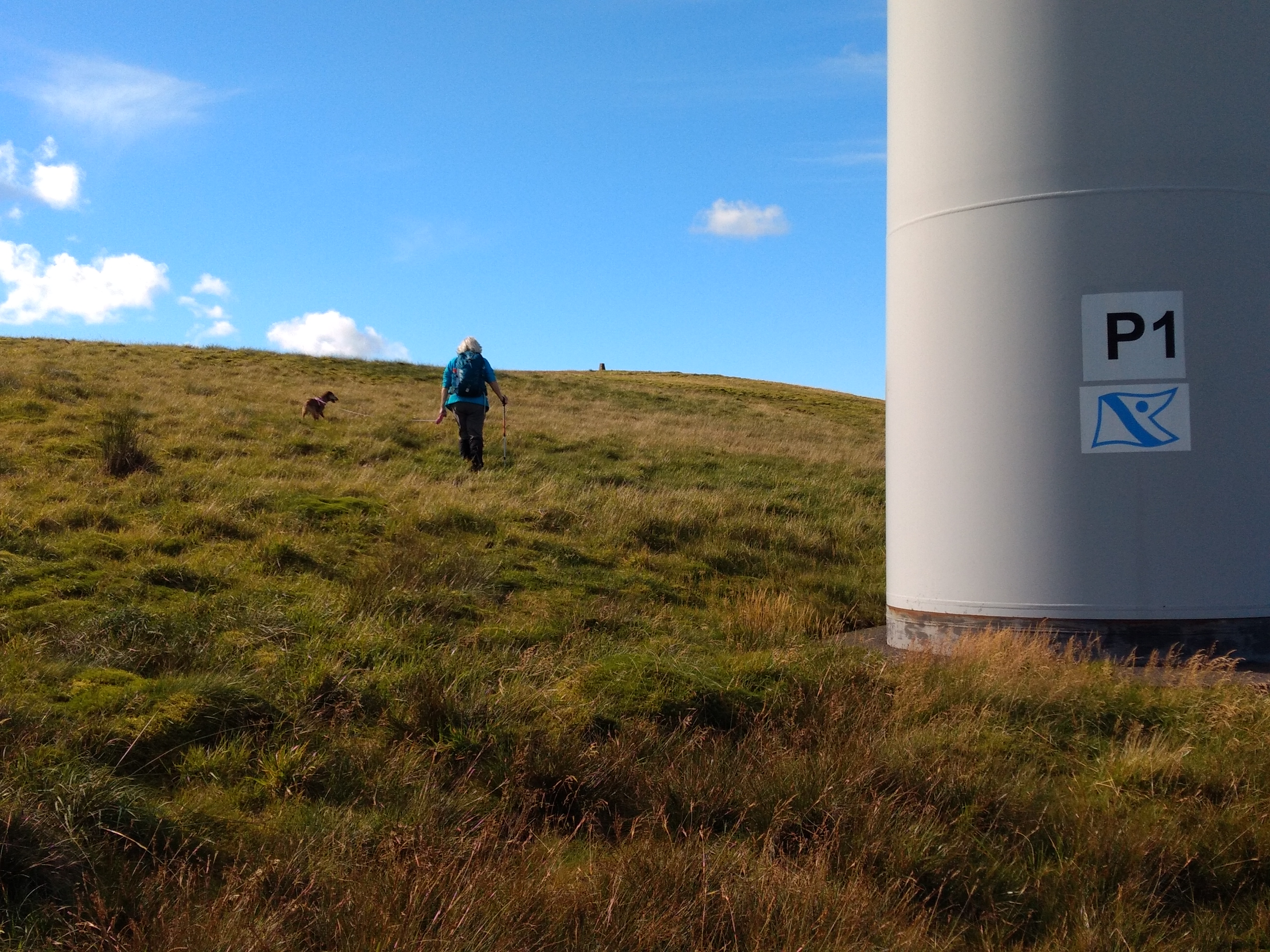
Our arrival on the Tuesday in pouring rain did not bode well and Wednesday was not much better, however taking a chance we set off well after breakfast to the Pentland Hills, around 25 miles north of our hotel. I hadn't activated in the Pentlands before and GM/SS-282 East Cairn Hill was chosen as one to do in a single day outing, being around a 7 mile return walk from Badingsgill Farm along "Thieves Road", the Cross Borders Drovers Road. I was accompanied by XYL Judy and our dog Treacle. Parking with permission was given at the Sawmill, grid reference NT126548. The route started on tarmac, went to a track once Badingsgill Reservoir was reached, and then later earth. The air was damp and when we turned right at Cauldstane Slap NT117588 and it started to rain.  


Cauldstane Slap with East Cairn Hill in the background 

We followed the fence running north east and pitched the HF station at the col and fence corner between the 561m and 567m "double top". The col falls to 548m so it was well within the activation zone. A 5m pole was used with an inverted vee dipole and Elecraft KX2. Due to the incessant rain only 14 MHz (20m) CW was used. I was forced to close the station down after ten contacts when callers ceased, to protect my transceiver. 

                              Miserable conditions on the summit for Judy & Treacle

XYL Judy, Treacle and I beat a hasty retreat back to the car and it rained all the way back. I was soaked to the skin despite my Paramor Coat being re-proofed the last time it was washed. Judy's Berghaus jacket kept the rain out, compared to my ten years old Paramo - I think it may be due for replacement.

GM/SS-195 Mendick Hill 06 August 2020

The weather was much better and after a fated cooked breakfast we headed north again to the Pentlands Hills near Edinburgh. The plan was to activate both Mendick Hill and then Wether Law. In the event, a bout of sickness and diarrhoea which came on me at 2.00pm shortened our day in the Pentland Hills....

©Crown copyright 2020 Ordnance Survey Media 010/20

We parked just off the A702 NT109479 and made our way along the waymarked footpath to West Linton. I was following a route through a sand quarry provided by my friend Terry, G0VWP. We left the path near some large plastic greenhouses below us and headed over Ingraston Hill, contouring round to approach the summit of Mendick Hill from the south. There were a few gates along the way and tussocky and rough ground in places. 

The memorial bench on the summit, a metre down from the trig, was very useful and that is where I set up my station. Before calling for stations on HF I gave a call on 2m FM with my handheld and whip and worked Colwyn MM0YCJ/P on SS-184 Middlefield Law, some 50 Km distant. I followed on with a contact with Steve MM0XPZ near Greenock and finally Andy MM0FMF over the hill towards Edinburgh, before moving to the KX2 on HF to make a further 24 contacts in Morse and Voice. 

Having joined a proper path near the top we opted to follow that down. It was a little further to walk but a good surface on which to walk, albeit it was steeper - but as we were heading downhill that wasn't important. We rejoined the West Linton path almost 2 Km north east of where we had left it on our way up. Its always good to follow a different route down and map it if it is a practical alternative, and this was. 

After a sandwich we drove to Halmyre House, the parking place for GM/SS-177 Wether Law, however by the time we got there I felt too ill from the food poisoning and had no choice but to return to the hotel, albeit with several stops along the way. 

I will return to the area later in the year, to activate Wether Law.

Tuesday 3 March 2020

G4OBK 1st E-Bike SOTA Activation G/TW-001 Round Hill

©Crown copyright 2020 Ordnance Survey Media 010/20
Whilst I have cycled to summits several times in England and Scotland to activate them for SOTA, this ride was the first on my Bergamont E-Horizon 6 hybrid Electric Bike, which I purchased last September after hiring an E-Mountain Bike as a try out when I was on holiday in Austria. The bike is standard, except I have fitted a saddlebag which carries my radio and a few bits. I also upgraded the tyres to a more knobbly grade - Schwalbe Smart Sam. My travel pole and aerial parts were carried in a rucksack. Here is my trusty stead before it got covered in sand from the track:

The route chosen was from Bransdale, starting at SE633960, parking roadside on the moor. A track built for shooters goes north from here passing grouse butts (with many grouse calling). The direct distance to ride to the summit of Round Hill on Urra Moor from the Bransdale Road is just under 6 miles. I set off on my ride a few minutes before 1400 UTC. A steady ride (with a 1.5 mile routing error) which took me 50 minutes to cover the 7.25 miles and there I was on the summit. The e-bike has 4 levels of power drive available from the Bosch 11AH 400WH 36V Powerdrive battery. These levels are ECO, Tour, Sport and Turbo, easily set by a control on the handlebar. It also has 9 gears which I use all the time to match my effort with the amount of E-drive. So you can make your ride as easy or as hard as you wish....  On the ascent I ran the power at around 50% Tour, 20% sport, 20% Eco and 10% Turbo. On the downward leg I used mostly Eco and Zero on downhill sections, Tour setting provided a little help on the few short uphill sections on the return. The track surface had to be observed closely on the ride at all times, so as to pick the best line, as with any riding on rough surfaces. On the sand sections of the track where it was not so well compacted, there was some drag on the tyres. This route was approximately 60% compacted sand and 30 % rough gravel and 10% cinder - which was the short section of the old Rosedale iron ore railway line from Bloworth Crossing.

On the summit 


It was a decent day for a ride and comfortable whilst sat doing the activation on the highest point of the North York Moors. I used an Elecraft KX2 Transceiver (as used now by Special Forces) with an inverted vee link dipole on a 5m high pole. I also carried a Yaesu FT4 handheld with RH770 whip, however this only produced one contact with M0SMP in Middlesborough. On HF I first tried 20m CW (Morse) and 10 CQ calls produced no callers, so trusty 40m CW it had to be, followed by a short session on 30m CW before my time ran out and I had to leave. The log contained two summit to summit contacts on 40m with HB9IIO/P Dan and HB9CBR/P Bruno - both stations in Switzerland. 
G4OBK/P Station log 03/03/2020 G/TW-001 Round Hill 
On my ride back the maximum speed of 25 mph was achieved with a more direct ride down without my earlier navigational error, taking 31 minutes. I saw just one person on my 2.5 hour expedition, a singleton trials bike rider on Westside road, which is one of the the few legal off road tracks on the North York Moors which 4X4 vehicles and motorbike riders are permittted to use. Westside Road joins into the better known Rudland Rigg byway, which continues down into Farndale. The range on my bike's digital read out read 65 miles in eco mode when I started the ride, however due to me using up extra power in Tour, Sport and Turbo mode, the range was down to 25 miles on my return to the car, despite having ridden just 13 miles and not 40 miles. This was as expected.

Sunday 5 January 2020

GM/SS-116 Almost New Year in Scotland - Colt Hill

Our final day as we departed from Gatehouse of Fleet in Dumfries & Galloway. I had put off activating Colt Hill on our arrival day three days earlier due to wet weather, however today was no better - it was wet, but we had no choice. We stopped off in Castle Douglas en-route for supplies. This is a lovely little town which even has a large Tesco Superstore, although we got our supplies from a small convenience store in the main street. From Castle Douglas we took the A713 north towards New Galloway and then cut across country to Moniave to follow the Dalwhat Water up the valley to the parking place for the walk to Colt Hill at Cairnhead, grid reference NX 702971. The last mile of road is unsurfaced, but safe to drive on with a normal car at a reduced speed.

The outdoor landscape artist Andy Goldsworthy lives nearby in Penpont and in and above this valley are four large Dumfriesshire sandstone sculptures he designed and led the building of called The Striding Arches - one of which is on Colt Hill itself.  One of the other arches is linked into Cairnhead Barn so before starting the walk from the nearby car park area we checked it out:
This like the previous day's walk up Beneraird, was a very straightforward walk which would have been excellent on a bicycle for most of the way. This time we walked a graded forestry track to a junction at NX 692991. If a bike had been used it would probably be best left here and then walk the rest of the way. From the junction a rougher and steeper path leads east for 550m to the Striding Arch and trig point on Colt Hill, GM/SS-116 at 598m ASL, the height qualifying the summit for SOTA winter bonus points. It took us 90 minutes to reach the summit over a distance of 3.35 miles with an ascent of almost 1300 feet. The pack was heavier today as we had a packed lunch and I had drawn the short straw so was carrying the 1 litre stainless steel flask of tea...

It had rained most of the way to the summit. We took shelter behind the arch and set up the VHF antenna by fastening the pole to the nearby fence:

I was again encouraged by the number of stations workable on 2m FM with a simple vertical dipole and 40 watts in England and Scotland, being Sunday and wet I guess that helped with plenty of amateurs home in the shack, including first in the log Geoff GM4WHA in Annan:

There were two S2S contacts made - with Colwyn MM0YCJ/P on Andrewhinney Hill GM/SS-083, and M7MVD/P on Dent G/LD-045 who was not particulary aware of SOTA despite the operator telling me he went up Dent regularly to extend his range on 2m FM... I was grateful for the S2S point either way.  After 15 minutes activity in foul conditions it was time enough to get packed up and head back to the car - a walk of around an hour. Once there we changed into dry clothing and drove home via Dumfries with our first rest stop at 1545 hours at the Tesco supermarket on Lockerbie Road, Dumfries for a toasted tea cake and tea in their cafe. The store remaining open until 2200 hours as Sunday trading laws in Scotland are different to England, where supermarkets have to close at 1600 hours. We reached home in North Yorkshire around 1930 hours. 
 ©Crown copyright 2020 Ordnance Survey. Media 010/20
Track above - GPX file shared in SOTA Mapping Project