Wednesday 9 September 2020

SOTA GM/SS-164 Kirkland Hill and GM/SS-186 Benbeoch

 Kirkland Hill GM/SS-164 - 9th September 2020

This early morning summit activation in Upper Nithsdale was a straight forward affair. There was room to turn the car round and park without blocking access to the cattle grid at NS745164:

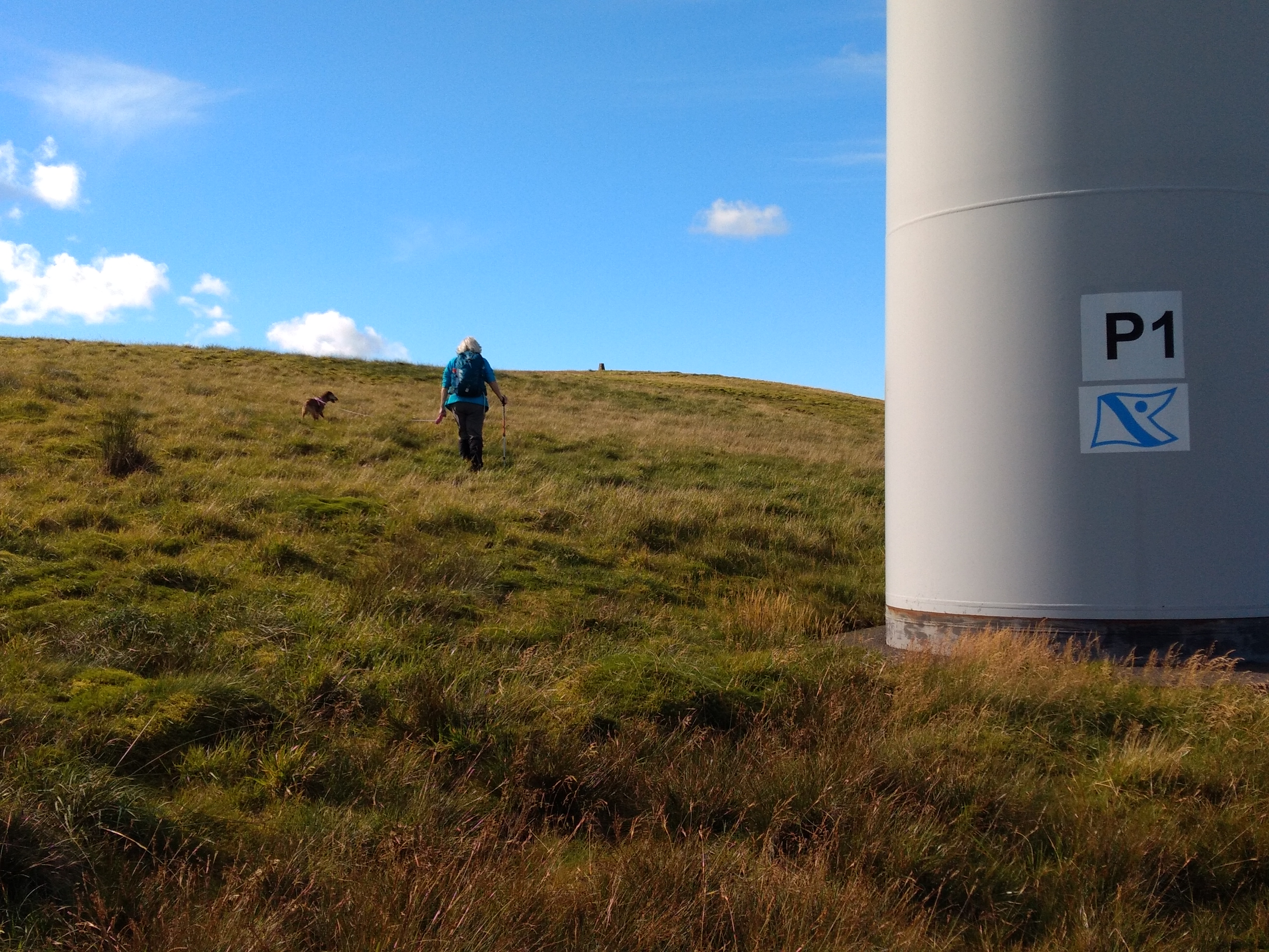
A 33 minute climb up the bland moorland took me to the trig point. It wasn't so boggy, just a little tussocky. There was one gate in the fence at NS736166. On the way back down I cut across the moor and climbed the fence. I then came across a track which went straight down the hill to join the track running alongside March Sike:

With a 5m pole and dipole with my KX2 I made 13 contacts using Morse and 3 using Voice, all on the 40m, 7 MHz band:
It wasn't a bad morning, but I had another summit to go for so I limited my time by not going on other bands, By 0800z I was leaving the summit and heading back down. 


Benbeoch GM/SS-186

Having driven early morning from a holiday cottage near New Galloway I headed back in that direction, passing the road end in New Cumnock to Glen Afton, which leads to the summits activated a few days previously Windy Standard and Blackcraig HillI was driving on the B741 and one mile before I reached Dalmellington I found the usual parking place for Benbeoch in a lay-by at Pennyvenie Bridge. 
Benbeoch is above a large area of worked out opencast coal mine workings, which need to be negotiated to gain access to the summit. A couple of barbed fences were climbed and a banking in a copse and this led me on to one of the mine access roads just south of two lagoons. It was quite an eerie place - thankfully there was no one around and all I could hear was the sound of running water and a buzzard squeeking and circling above me. A wide graded access road (next picture) took me north and to ease the gradient and rougher ground I went left before climbing a banking
 
It wasn't a bad choice and the unchartered route took me to a wall and fence corner at NS495079, the summit can be seen above my rucksack:
I came back to the same point on my way down, although I took a steeper way down to reach it. Continuing on to the cairn above the crag, the ascent took 55 minutes. I had more time to spare on this summit so ventured on to the 20m band as well as 40m, where conditions were not so good to Europe. Five S2S contacts were completed out of the twenty in total. It started raining then, just a shower but I wanted to get back to the cottage for a late lunch so I called it a day and packed up:


Pictures above of the cairn with my 5m Lifes-a-Breeze travel pole supporting a link dipole for 20m, 30m and 40m. The bottom picture is a view of the opencasted area below the summit. I opted for a more direct walk down, spotting a small brown deer living in the area of the opencast mine on my way - there are better places for a deer to live I'm sure! Nearing the B road I opted for an earlier exit from the site out on to the road. I was glad to get this summit completed as there could have been issues with access, but no person was encountered during the activation.

Tuesday 8 September 2020

SOTA Blackcraig Hill GM/SS-070

The summit of Blackcraig Hill SS-070 lies to the north and is on the opposite side of the Afton Valley to Windy Standard SS-071, which I activated two days previously. This was the first activation of the summit in 2020.

Blackcraig Hill September 8th 2020

Ascent: Distance 2.75 miles / 1450 feet (Time taken 1 hour 34 mins) 

Depart from vehicle 10:34 BST Arrive summit 12:08 BST (Cairn) 12:15 BST (Trig)

Return to vehicle: 14:46 BST

©Crown copyright 2014 Ordnance Survey Media - GPX track can be downloaded from the SMP

Our car was parked to the side of the access track to Blackcraig (farm) just off the Afton Valley road. For the most part once beond the farm the track is graded almost as far as Quintin Knowe which suggests that another Wind Farm may be planned up here for the future - there is already one located on Hare Hill 2 Km to the north of Quintin Knowe.
 
 The graded road which almost reaches Quintin Knowe


Once the gate is reached at Quintin Knowe the fence is followed to the right until the large summit cairn is seen. This is within the activation zone, however we went a little further and climbed a stile which took us some distance away to the trig point. The trig point was open at the top with sufficient space to support my 5m fishing pole inside it:
 

The summit is not particulary good for VHF and only one contact was achieved - this was a good one though, to Derek G1ZJQ/P who was on G/SB-007 Tosson Hill. 40m and 20m CW were utilised until the rain started so without any cover to protect my KX2 I closed down with 20 contacts in the log:
Elecraft KX2 with 8 watts to an inverted vee link pole

Sunday 6 September 2020

SOTA Windy Standard GM/SS-071

Windy Standard GM/SS-071 is one of two summits above the Afton Valley in East Ayrshire, which were activated for SOTA separately over two days in September 2020. The other summit above the Afton Valley is Blackcraig Hill GM/SS-070.

Windy Standard September 6th 2020

Ascent: Distance 3.75 miles / 1300 feet (Time taken 1 hour 43 mins)

Depart from vehicle 14:15 BST
Return to vehicle: 18:52 BST 

We parked for Windy Standard at Afton Valley Filter Station NS627056 for this afternoon activation. An uphill path leaves the track going to Afton Reservoir 250m from the carpark:

We passed this unusually shaped fir tree on the slant path to the service road:


Soon the wind farm service road was reached and followed over Lamb Hill and Wedder Hill.

Wind farm access track leading up to Wedder Hill

Drink Stop on service track near Millaneoch Hill above Afton Reservoir

Treacle at a wind turbine base - our cross Border Lakeland Terrier

At Millaneoch Hill an easy to climb fence at NS630021 was overcome and then the same fence was followed up Blackgrane to the Windy Standard Wind Farm, a most appropriate name for the facility! Once again a service road was joined for a short distance, before the trig point at 698m is seen on the top of the moorland:

The final approach to the summit trig point was over grass

The station was set up and qualified initially on 2m FM with six contacts using my Yaesu FT-4X handheld and RH770 whip. Being Sunday on a site with good VHF take off in all directions there was plenty of activity with contacts into Cumbria, and Annan, but the most appreciated VHF contact wassummit to summit with Jack GM4COX/P on Ben Cleuch GM/SS-059: 

Summit Photos:


I operated for 40 minutes on 2m FM and 20m, 30m and 40m CW and completed 27 contacts, the furthest being Jean-Paul, AB4PP in North Carolina.  Station used was Elecraft KX2 and link dipole on a 5m pole. After a successful and comfortable activation we set off back, making a slight variation in our route around Wedder Hill (GPX file can be downloaded from the SOTA Mapping Project and SOTLAS):

©Crown copyright 2014 Ordnance Survey Media
Note this map is from 2014 and does not show the Wind Farm access tracks

The descent track was further but it saved going up and down Wedder Hill...