Wednesday 25 March 2015

Benelux Tour Day 1 ON/G4OBK/P + F/G4OBK/P

Day 1: 21st March 2015

ON/ON-027 > ON/ON-021> ON/ON-006 > F/NO-047

I organised a trip to the Benelux Countries with my friend Nick G4OOE with the intention of completing activation's of all Belgian and Luxembourg Summits. I was the navigator and Nick was the driver of his Kia Sorrento registration no. G4 OOE, and this is the story of how we did it...

P&O Pride of York Hull - Zeebrugge
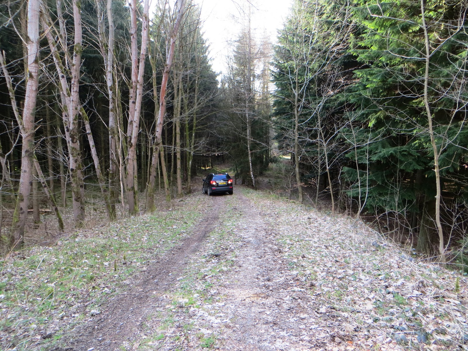
To complete the list of summits I had on my list meant we needed to be away for five full days. P&O Ferries operate a daily service from Hull in East Yorkshire to two ports in Netherlands with sleeper berths and car ferry included in the price. We missed the SOTA winter bonus period by two weeks, but the price was right - the costs of the crossing escalate once Easter week is reached. The boat leaves Hull early evening time and to maximise the time available on Day 1 we chose the crossing to Zeebrugge rather than Europoort (Rotterdam). Our ship was the Pride of York, an old boat which was not so comfortable and with less facilities than the boat we returned on five days later from Europoort. We had a quiet night with little to drink and disembarked around 9.00am into the Belgian Port. Our first stop was an amateur football pitch on the top of a summit plateau east of the town of Ronse.

Equipment used:

One Yaesu FT-857 each running 30 watts CW/SSB
Batteries: Phil used 7 AH LiFePo4 Nick used LiPo 5 AH
Antennae: Phil used link dipole 30/20/17m Nick used 40m dipole
Masts: 6m long (57cm telescoped) travel poles
Palm Morse Keys standard Yaesu Microphones

Navigation:

TomTom Via 135 EU Mapping + OSMAND+ Android App (Road)
Garmin GPS62s with Open Street Map installed preloaded with most likely walk routes
Self Printed maps where needed from Garmin Base Camp running OSM
Pre-Planning Tools: SOTA Mapping Project (SMP) by Rob DM1CM and Open Street Map running in Garmin Base Camp - where useful post event GPX Tracks have been uploaded to the SMP

Pottelberg ON-027

It was a grey day in Belgium as we pitched up our separate stations on the "drive on" summit, the two station arrangement being a trend we continued throughout our tour. We had two problems on Pottelberg, it started to rain and a nice man arrived to white line the pitch for the game later that day! The rain forced me and Nick to QRT early and that saved the radio getting limed on, as I set up in the goalmouth of the pitch, using the goalpost as a support for my pole. The groundsman was a cheerful fellow, intent on repeating how enjoyable Belgian Beer was with hand movements with his drinking arm. I already knew Belgian Beer was good and agreed!

Groundsman white lining:  "Belgian Beer, Belgian Beer, Belgian Beer" he kept saying
As the groundsman drew close and the rain started I saw Nick was already dismantling his station at the other end of the pitch and after working down 30m CW until nothing was left I also shut down. 

Rucksack packed up at my operating position on Pottelberg and ready to leave


Time to go.... we set off for ON-021 Plantis de Mesnil - our next summit. 

Plantis de Mesnil ON-021

A long drive well south of Namur brought us to a road alongside a wood, in the french section of Belgium. We pulled into the woodland safely off the road and were well within the activation zone. Moving some distance from the car we set up our stations. All summits today were "easy drive on's". 


We operated on the 20, 30 and 40m bands in CW/SSB and didn't stay long before we departed to the double border summit of ON/ON-006 and F/NO-047. The joint summit was not so far away. 
La Croix Scaille ON/ON-006 with F/NO-047 Moulin de Thilay

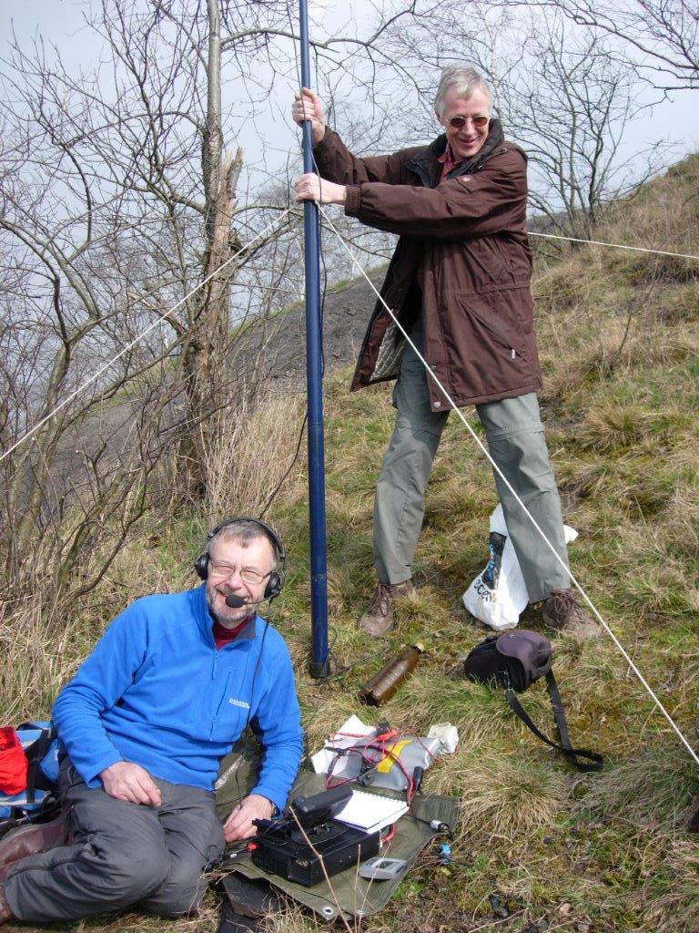
The area we were in is known as the land of the valleys and no sooner had we left the car at the border post separating the Belgian from the French side when the voice of Christophe ON6ZQ came crackling through on the 2m FM handheld I was listening on. Our pre-aranged meet up had worked and he was on his way! A 2m FM Chaser point was given to Christophe who was some miles away, then and I continued setting up my station on the Belgian side of the barrier.

Nick (in France) took this picture of me setting up my station (in Belgium) before Christophe ON6ZQ arrived
Nick was around 150m away from me setting up his station on the French side NO-047, which was well within the 25m drop zone of the actual highest point of the French summit. 

Get them while you can... This summit will soon be morphed into one and become a singleton SOTA rather than a dual. I've activated a few dual SOTAs before on the German - Austrian border, they will soon no longer exist....

Rain had started to fall again as I popped into France to see Nick's before taking over
Christophe ON6ZQ appeared for the summit handshake, bearing a gift for the two G stations - a box of fine Belgian Chocs!  Lovely, we had two each night and saved the XYL the rest for when we got home. Thank you very much Christophe - for your most generous gift.

Nick G4OOE left - Belgian Chocs centre - Christophe ON6ZQ right
We had a good chat and as Christophe departed we finished off the activation as it approached dusk and then we drove the car around the corner of the wood to the summit tower structure - wow that was something else. It was too late in the day to climb as the access gate was locked. Most impressive:


We were booked into a hotel in Rochefort called Le Vieuw Logis. This was in a historical part of french speaking Belgium. We both agreed that despite the hotel being the most expensive of the places we stayed in we liked it the least. Arriving in the dark meant we couldn't see where we where and the check in was impersonal and not helped by the language barrier. I was surprised to find that my few words of french where more than the french lady owner had in English, now that is rare! We are such a lazy race when it comes to learning a second language.... I just have a little school French but I never took the exam preferring as a choice Geography instead...

Hotel Vieuw Logis in Rochefort next morning - parked right outside the door
After checking in we ventured into town and found a Fritterie, where good food was quickly served with a few beers, just what we needed. It had been a good first day with no problems. I thought conditions were down on 20 meters. Tomorrow we had another social gathering at our finish hotel in Bastogne, with Peter ON4UP - Belgium's SOTA Association Manager and his and our friend Franz, ON9CBQ. This was more of a reunion than a straight meeting as we met up with Peter and Franz in June 2014 when we had a joint Belgian - English activation of the 8 point summit of ON-010 Baraque Fraiture.

Day 1 Bands used: 40m, 30m, 20m CW & SSB
Day 1 QSOs completed (both stations): 144

Tuesday 24 March 2015

Benelux Tour Day 2 ON/G4OBK/P + LX/G4OBK/P

Day 2: 22nd March 2015

ON/ON-019 > ON-004 > LX/LX-002 > LX-004

Bois de Javingue ON-019

Writing the blog up several months later now...at least I have some photos to remind me how we got on which helps me to bring back memories as I write...

The four summits today were all pre-planned with two in Belgium and two in Luxembourg, which meant that today was completion day for another country, but for a country the size of Luxembourg that is easy. There are only four qualifying summits and they are regularly activated for SOTA. 

A short drive from Rochefort took us to a track above a village called On.  We approached the top of the wooded summit called Bois de Javingue from the north east side, using a metalled road called Allee des Moineaux, which is shown on Open Street Map.  We turned right down an earth forestry track at the highest point, with Nick managing to park his 4X4 to the side of the track before it became too rough to drive on. Going down that track saved us around a 500m walk...

Nick returning to his car after the activation of Bois de Javingue ON-019
A 10 minute walk down the track took us to the highest point in the bois (wood in English) and we set up in trees about 50m apart. Amazingly, for part of the time, we were able to operate on the same band in different modes by moderating our power. 

Nick G4OOE got this picture of me working in SSB mode - ON-019 Bois de Javingue
All told we made 78 contacts between us in 50 minutes - including summit to summit QSOs with our good friends Franz ON9CBQ and Peter ON4UP who were on ON-021. We made arrangements to meet up later that evening. Time to pack up then and head off to ON-004...

Bois de Hazeille ON-004

Another bois (wood) but this one had been thinned out and coppiced - the reason being that an air traffic communications installation is situated on the summit. This high place is east of a small town called Saint Hubert - easily found using the SOTA Mapping Project which links to Open Street Map. The road used to access the top of the hill is Rue de Monastere. We were aware that questions had been asked of previous activators setting up for SOTA here, but this day, even though the station was manned (we observed several parked cars as we passed the main station building) no one bothered us as we proceeded with our activation. As usual we set up two stations, this time around 200m apart on opposite sides of the track. The road is very good tarmac right on to the summit.

Nick ON/G4OOE/P at his station - 6m high travel pole and FT-857 dipole on the 40m band 


Radar Scanner on ON-004 Bois de Hazelle - a 6 points "drive on" summit with no questions asked of us...
We adopted the usual routine with Nick sticking with the 40m band and me on 30m and 20m. I had a good session with 54 contacts in 40 minutes before packing up and we headed into Luxembourg via the Motorway and avoiding the city centre, to activate two more SOTAs there. 

Grengenwald LX-002

I had activated LX-001 and LX-003 with Nick the previous year when we visited the Friedrichshafen Ham Radio Convention, so that left two summits to complete the country. 

We had been warned by our friend Christophe ON6ZQ the previous day, that it is dangerous to walk on the N11 - a very fast highway which runs parallel to the wooded summit of Grengenwald. We found a short track leading down a slope off the N11 however  at N49.6689 E6.2034 which was easily negotiable with Nick's 4X4. It would be OK in a 2 WD car also providing the road surface was dry. Otherwise, there is room to park off the main carriageway without needing to go down the slope, but if you parked there your car could be seen by passing vehicles and may not be quite as secure as ours was down the slope and out of sight... 

Parking place at LX-002 around 100m down from the main N11 highway
We left the track and chose a favourable route through the woodland up to a through track running right across the top of the woodland, frequented by walkers and horsewomen. The route plainly goes from somewhere to somewhere, but with only activating SOTA on our minds we did not ponder this for too long... 

Open Street Map of LX-002 viewed in Garmin Basecamp
Within 12 minutes we were on the track at the highest point of the wood finding two places to position our HF stations. We ended up around 300m apart. If you study the map the blue flag shows where we found a bench seat on our way back to the car - I could have sat there and operated had I known about it in advance. I will head for that next time I visit...

The bench seat - found on our way back to the car after the activation N49.6730 E6.1964 degrees
As Nick backed the car up the slope I was thinking about our next activation, in another wood not far away, when we would both SOTA Complete Luxembourg.

Nick reverses out of the forest road - on our way to LX-004
Widderberg LX-004

I think its safe to say none of the LX summits are difficult. They all lie in woodland and are easy to access. We parked the car for them all as near as we believed we could get to the top, and the walk to the summit of Widderberg took just 12 minutes! 

A typical central European summit away from the mountains - sat on piles of old brown leaves
It was here where we met a couple of teenage local lads who had lost their dog in the wood and came across us operating the radio's during their search. We hope they found their dog, we never found out...

It was approaching late afternoon and the bands weren't in bad shape with Bob AC1Z my best DX worked on 20m CW. The vast majority of my 43 contacts made were on the 30m band, with the very loud and experienced Marko OH9XX the first station of my session logged.  

Log2map of LX contacts made by LX/G4OBK/P this day (Thanks ON6ZQ website)

We packed up and made our way back over the border into Belgium to Bastogne, where we met up with Peter ON4UP and Franz ON9CBQ for a very enjoyable evening in the restaurant of the Hotel Giorgi where we stayed that night, located in the town square.

Phil G4OBK, Franz ON9CBQ, Peter ON4UP Nick G4OOE enjoying a social meal and drinks in Bastogne
It had been another good SOTA day with no problems encountered along the way. 

Monday 23 March 2015

Benelux Tour Day 3 ON/G4OBK/P

Day 3: 23rd March 2015

ON/ON-010 > ON-018 > ON-024 > ON-025 > ON-001

This was the morning when I lost my passport in Bastogne....

The previous evening we had met up with Peter ON4UP and Franz ON9CBQ in a restaurant in Bastogne adjoining our accommodation. After a few beers I had left the meeting to check in at the reception at the Hotel Giorgi around the corner.... This is where I had presented my passport to the receptionist, and that was the last I saw of it, it seemed. I woke up the next morning to find it was not in my trouser pocket where it normally stays on these trips! Panic set in as I thought we would need to spend the day driving to Brussels to obtain a temporary passport. Calming down I retreated my steps from the previous evening in the reception area, and in the adjoining street - without finding the passport. The reception was unmanned and it occurred to me that I had better check under the all in one printer/scanner cover behind the desk. I lifted the top of the unit and there was my passport! Sigh of relief and we got on with our breakfast... 

Breakfast in Hotel Giorgi - I'm happy now having found my "lost" passport
ON/ON-010 Baraque Fraiture

Leaving the square early in Bastogne in fair weather we made our way north, stopping off on a summit we had visited before on our trip to Friedrichshafen in June 2014 - this was ON-010 Baraque Fraiture. It would have been wasteful to pass by without snatching the eight points on offer even though it was not a unique summit for either of us. Summit details are here from our previous activation. I took a turn on the 40m band here for a change and logged 37 stations in 20 minutes, of which 20 were in the UK - all on phone. ON-010 is activated regularly owing to its easy to reach location by car - as a SOTA Chaser I have had 21 contacts with ON-010!

ON/ON-018 A la Plate

Less than an hour after leaving Baraque Fraiture we arrived via an asphalt road at a good clear parking place above Weris for ON-018 A la Plate. An easy walk of 10 minutes on a track took us to the highest point and we set up amongst some saplings in the woods. 

My set up amongst saplings just off the track on ON-018
Reverting back to our normal practice of Nick using 40m and me using 20m and 30m I was on the air for less than 30 minutes before packing up to head for Bois de Tour de Coo ON-024. 

ON/ON-024 Bois de Tour de Coo

The writer pointing to the path up to ON-024
This was one of the trickiest to find paths on our Benelux Tour. The summit is above a permanent rural funpark with rides with such names as the Mega Mindy Flyer! We parked in a cemetery car park just off a road called Grand Coo and after a false start when we went off in the wrong direction, we walked west along the road from the cemetery and found a path going up the steep bank on the left which wound its way to the summit track.

There is a less steep but longer way up, but this path suited our needs and it only took us 15 minutes to reach the highest point. Here is my track ouline as loaded into the SOTA Mapping Project:


There were a few walkers passing by on the recently gravelled track adjacent to where we set up our stations:

In the middle of the day radio conditions were not so good and I was operating for 25 minutes before we packed up to head for our next Belgian summit. 

ON/ON-025 Burteaumont

How close can you get to the summit in the car? Often the question is unanswered until you get into the vicinity....

We planned to park at the top of the picture and walk up to the end of the line in the picture. As it happened the road was tarmac so Nick drove up close to our operating positions. The passing farmer was not concerned as the road was not blocked
It took well under an hour to drive from the cemetery at ON-024 to reach the top of ON-025. We drove up an asphalt farm track and parked almost on the summit. Passing farmers in their tractors towing slurry tanks were disinterested and gave us a wave as they went by our stations on the summit, and the smell wasn't so bad either:

We were on the edge of a private wood where the summit is inside but the track which we set up alongside of the wood was well inside the activation zone at 10m down from the highest point. I logged 34 stations in 20 minutes on 20m and 30m, with my final contact being on 40m SSB using Nick's radio, when we both worked our friend in Malvern, Geoff 2E0NON. Time to move on then and do our last summit of the day which I activated in 2009.  We drove through the town of Malmedy to the highest point in Belgium - Signal de Botrange ON-001. 

ON/ON-001 Signal de Botrange

One of the easiest 8 point summits in the world - ON-001
When I came here in June 2009 I was bitten badly by the small black flies, but in March 2015 this was not a problem. We walked down from the main road on the opposite side to the restaurant and tower and set up both stations on and next to the wildlife viewing platform. As usual Nick went on 40m and I used the 30m and 20m bands completing 42 contacts. 
The SOTA Flag is flying on Signal de Botrange
Job done we headed off to the large town of Verviers, where we stayed for one night only at the Hotel Van der Valk. This was a large corporate style hotel which was formerly a large railway warehouse:

We walked into the town but struggled to find somewhere to eat. Eventually we came across a nice looking bar for some more Belgian beer and a steak and chips meal.  The following day we were hoping to complete activating all Belgian summits before heading into the Netherlands to finish those off as well... 

Sunday 22 March 2015

Benelux Tour Day 4 ON/G4OBK/P + PA/G4OBK/P

Day 4: 24th March 2015

ON/ON-026 > ON-029 > ON-028 > PA/PA-003 > PA-002

We split our five summit day today between Belgium and Netherlands. 

ON/ON-026 Le Mont d'Henri-Chappelle

As we were 'room only' at the Hotel Van der Valk in Verviers we got an early getaway and proceeded to ON-026 where a main road passes over the summit at 354m. I'm sure there are better places to operate, but with a tight schedule planned for the day, including a meeting with Lutz DL3SBA, we opted for the most convenient place - in what looked like the car park of a college. Using 20m and 30m it was too early for inter EU contacts, with only 7 being made on 30m. I moved to 20m and completed just one contact - with VK5CZ on the long path. 

Nick ON/G4OOE/P operating on 40m in the car park of the college on the 40m band
After 20 minutes with no answers to CQ calls we went QRT and drove into the small town of Mont d'Henry Chappelle itself for our breakfast - two coffees each and some lovely pastries. It was then when we saw this sign, showing that the town is within the 25m activation zone at 339m ASL: 


Apart from my contact with VK5CZ this was a disappointing activation in many ways, but we made up for it later in the day when we met up with Lutz, DL3SBA and his fabulous dog Noah. We left the patisserie in Chappelle and made for a suburb on the northern outskirts of Liege for our penultimate Belgian summit. 

ON/ON-029 Terril Ste-Barde et Tonne


We parked the car G4OOE in Rue Naniot, a suburban street adjacent to the hill we had to climb:


The hill was a landscaped wooded spoil heap of compacted coal dust. It was clean though for sitting and we chose two operating positions a few hundred metres apart on distinctly separate hillocks.  As usual we kept in touch with our 2m handhelds. It took just 13 minutes to reach the top. 
Spoil heaps in Open Street Map seem to be shown in black whereas quarries are shown as white...
This picture featuring Nick gives a flavour of what it is like on top of ON-029:


I was only on the air for 10 minutes here. 12 stations were logged, with only two on 20m. Condx were lousy and when the CQ calls failed to produce after a SOTAWatch spot I gave up and closed down my station. Next stop - an even bigger spoil heap with a most interesting name and for both of us, our last Belgian summit...


ON/ON-028 Noordelijke terril Waterschei

Driving north now to the industrial town of Genk to a large car park which serving Genk Football Club, one of the most successful clubs in Belgian Professional Football that play in the 1st division. We parked towards the back of the car park nearest to the hill, which was the largest pile of lightly wooded black spoil I had ever seen, and we were to climb it - our last of 17 Belgian summits:

Looking at the hill as we approached it we favoured the path slightly to the right. This turned out to be steeper than it looked and quite a struggle to reach the top without falling backwards!  We came down on the better path to the left side which I would recommend. This is the GPX track I loaded into the SOTA Mapping Project:


Nick climbing the last steep section to the summit:


We knew it was likely that Lutz DL3SBA was likely to be on the summit, but from where we stood on the car park he couldn't be seen. As we climbed up the final section a head and shoulders appeared above us, and yes, it was Lutz our German friend and his Bernese Mountain Dog Noah...

Left to Right - Lutz DL3SBA, Noah, Phil G4OBK and a passer-by who liked having his photo taken!


Lutz is one of the top German SOTA 
activators and we'd had so many contacts on the radio. As usual Nick and I had carried up our own stations and this was completely unnecessary as Lutz had his powerful station already set up for us to use. This was a Kenwood TS480 (Power used - 50 watts) and a high dipole. As Lutz prefers phone to CW I got out my small Palm Key to give some variety to the activation and made 12 contacts in Morse before handing over to Nick on SSB who made 47 contacts all on 40m in less than 30 minutes, dealing with a huge pile up until it concluded with no more stations calling at the end. Here is Nick enjoying using the Heil boom-microphone headset and PTT switch favoured by Lutz: 


After a lengthy session operating and chatting we left Lutz to finish the activation and arranged to meet him later in the day on our next summit - over the border in the Netherlands. On the way to the border we stopped off at a McDonald's for a fast food burger meal lunch... We were both satisfied having activated every Belgian summit now - which was one of our goals on this Benelux Tour. 


PA/PA-003 Observant (Sint Petersberg)

Peter ON4UP (SOTA Association Manager for Belgium) is a useful guy to know and he told us about a good place to park our car when we went to activate PA-003. We approached by car from the  village of Kanne via Casterweg and Silexweg until we ran out of road near a football pitch. There was room to park at the end when it became a rough walking track. If you decide to go that way you'll find details in the SOTA Mapping Project webpage.  From there we found an excellent walk route to the summit - it took around 15 minutes a great picnic area with tables overlooking a quarry and the big concrete works just south of Maastricht - a famous place because of the controversial treaty which was signed there by country members of the European Community in February 1992.

Setting up and operating in comfort on PA-003:


The top was lightly wooded and there plenty of places to fix our antenna to. We just set up one station and shared that and we were well into the activation when Lutz arrives carrying two bottles of excellent German beer for us to drink! 


We found the trig point before leaving the summit... and then Lutz DL3SBA and Noah arrived with a surprise - the German beer. I operated for 20 minutes and Nick did around the same before we closed down. It was getting towards the end of the afternoon and with little daylight remaining we needed to move to our last summit of the day. We completed 68 contacts between us on 20m, 30m and 40m in CW and SSB...

I made a short film of Nick operating CW on PA-003. He wasn't aware at the time that I will filming him, click the   YouTube link below to see a true pro in action using Morse Code:  

PA/PA-002 Vrouwenheide

The summit was well past Valkenburg where we had our hotel booked for the night. We drove south of the town of Ubachsberg and turned left in the hamlet of Mingersborg to arrive at a parking place near a wood which was the summit. A short walk took Nick to the trig point in the wood. I found a place in the roots of a large tree to set up my station about 100m away. It was cold, starting to rain and the light was going as it was dusk. I worked as quickly as I could and logged 63 stations in 40 minutes. My best DX was RV9DC in Ural Russia on the 20m and 30m bands and K4MF in Florida on 20m CW. 


The last summit of the day done we made our way to the Hotel Walram in Valkenburg. This turned out to be a coaching hotel located in a historical tourist town full of restaurants. We chose a restaurant after a walk around the town in the rain, but it turned out to be quite expensive. One day to go then and after a discussion and considering the weather forecast, which was not good with heavy rain to come, we decided to stay in the Netherlands next day and complete the country by heading north to activate PA-001 and PA-004 before heading for the ferry at Rotterdam Europoort...

Saturday 21 March 2015

Benelux Tour Day 5 PA/G4OBK/P

Day 5: 25th March 2015

PA/PA-005 > PA-004 > Ferry home

PA-005 Galgenberg (Terlet)

As expected our last day was wet right through until the afternoon. The two summits in the north of the Netherlands (if you can call them summits - they aren't) are located 150 Kms north of the two southerly summits near Maastricht. After breakfast in Valkenburg we drove north through rain up the A50 motorway. Without my usual meticulous planning, having decided to go there the night before, we sailed past the summit on the motorway, and so had to turn off at the next intersection and follow a minor road back adjacent to the motorway to reach it.

The summit is on a caravan / camping park and to reach it you drive through a glider aerodrome. There was no one around and the campsite was deserted. We drove straight into the campsite, parked up and walked about 100m to our operating positions. Brollies were deployed and we were able to complete our activation without any problem.  

There was some moorland on the other side of a fence at the top of the campsite where I found this memorial seat to Dirk (2010), so I set up there: usual kit FT-857 - 7 AH LiFePo4 battery, 6m pole and link dipole. I logged 30 contacts and the only UK station worked was my friend Terry G0VWP who lives in York. 


This was Nick's 40m station - we both have the same type of golf umbrella... he was up against the fence and quite close to the trig point, note the large caravan in the background:


My position on the seat was to the right of here and less than 100m away. We packed up, wet and continued to PA-004 west of Apeldoorn, our final summit of the trip...

PA/PA-004 Torenberg (Apeldoorn)

The actual summit is in secure private woodland which is controlled for some reason by government security personnel and police. We know this as we were approached during our activation twice by both divisions and interrogated!


The N344 road crosses the activation zone and we parked in a layby. This drew attention to our presence hence the visit by the security people. If you do activate here I would not recommend parking on the main road, better to turn off (on Kamsteeg perhaps - see SMP/OSM) and set up your station there. 

We set up about 50m inside the wood against the security fence. I would have taken a photograph but with two visits from the security people I did not want to get my camera out in case we were being watched. We were asked what we were doing, and our passports were scrutinised before we were left to continue with the activation completing 51 contacts between us. 

Here is a map of the PA/G4OBK/P contacts made from the 4 Netherlands Summits activated. 

So that was our 5 day tour of the Benelux Complete - Luxembourg, Belgium and Netherlands SOTA Complete for me, and shortly after my certificate arrived for Belgium:


It has been a successful tour, especially meeting up with ON6ZQ, ON4UP, ON9CBQ and DL3SBA. 

Summits activated: 20
Number of contacts (both operators): 1299

We boarded the Pride of Hull Ferry at Europoort and enjoyed the crossing, with a good meal, plenty of beer and live entertainment provided by a 1960s retro band who were excellent. The bigger P&O boats feature on the crossing from Hull to Rotterdam (Europoort), whereas on the Zeebrugge crossing the boats are older, smaller and are inferior in every respect. Something to consider when we embark on our next tour.