Thursday 13 October 2016

Catterblog reports temporarily suspended!

Apologies to readers for a dearth of Blog reports throughout the latter part of the summer and autumn SOTA Season, despite many activations taking place in the UK, Czech Republic and Poland..... 

The lack of reporting is because of a house relocation and station rebuild which is taking up all my time at present. 

Normal blogging will be resumed in 2017 when I find the time to catch up.

Best wishes 

Phil G4OBK

Wednesday 27 July 2016

A July Scottish Borders Day - GM/SS-122 The Wiss, SS-140 Turner Cleuch Law and SS-179 Cacra Hill

There still remains a number of Scottish Border summits that are reachable from my home in North Yorkshire - providing that I am prepared to drive up to 400 miles in the day and be away from home for around 16 hours. Today I was able to finish off three summits for SOTA Complete using the HF bands and 2m FM. 

The routes taken up to SS-122 The Wiss and SS-140 Turner Cleuch Law
After leaving Pickering at 5.50am I reached the cattle grid on the B709 road that lies between The Wiss and Turner Cleuch Law, both two point SOTA summits, at 9.30am. I was accompanied by my Border / Lakeland Cross Terrier Treacle once again, and we stopped en-route at the Southwaite Services near Carlisle for a comfort break. 

The parking spot at the cattle grid between The Wiss and Turner Cleuch Law
GM/SS-122 The Wiss

Setting out at 9.48am this was a straighforward trek to the summit. No section was particulary steep but there were a few broken fences for us to negotiate. The summit trig point was reached within 42 minutes. The GPX track I used can be downloaded (as all my tracks can) from the SOTA Mapping Project run by Rob DM1CM. 
Treacle at the trig on The Wiss GM/SS-122
Using a 5m HD travel pole and link dipole for 40/30/20m I set up my recently acquired Elecraft KX2 transceiver and a Yaesu VX-170 handheld on an extended RH770 whip. After testing out the KX2 on my recent SOTA Cycling visit to Gisborough Moor I had realigned the display which was now accurate and I had constructed and installed an internal battery pack.  The first contact on 40m CW was a super summit to summit QSO to Norway with Aage LA1ENA/P on LA/TM-134. I finished with 24 contacts on HF before turning my attentions to 2m FM where I was called by my friends Nick G4OOE/P and Dave G3TQQ/P who were on Helvellyn G/LD-003.

On The Wiss - KX2, FT-270, €5 boom mic headset, palm paddle key, logbook
My experiences with the new KX2 so far and throughout the day using just the internal battery are detailed at the end of this blog.... 


St Mary's Loch - visible from The Wiss GM/SS-122
Carson's Cleuch - on my way down from The Wiss
Arriving back at the car via the same route taken on the way up, I had my dinner and a short break before setting out refreshed for SS-140 Turner Cleuch Law. 

GM/SS-140 Turner Cleuch Law 

This was a shorter but steeper walk of just over 1 Km which was completed in 23 minutes. Keep climbing as you pass this fine cairn part way up the hill:


There was no trig point to support the pole this time but the fence running across the top did the job instead.
Operating position on Turner Cleuch Law
On my arrival the 2m FM radio opened up its squelch with a calls from G4OOE/P and G3TQQ/P who were now on the flank of Helvellyn descending back to Wythburn car park. Geoff G4WHA/M was then worked on his lunch break and on a hilltop close to Penrith. Not only that, but HF was in better order and 37 contacts were completed in CW and SSB in 42 minutes.  I was delighted with that as I packed up and made my way back down to the car.

GM/SS-179 Cacra Hill

Less than three miles south east of SS-140 lies Cacra Hill, which was easily reached via the B709 and B711 roads. My plan was to park near the cattle grid at Cacra Cottage and climb the hill from there. As I was starting out the farmer from the cottage spotted me and advised me that if I went that way I would encounter his bull. He helpfully suggested that I continue to NT 3130 1675 where I could park and climb the fell from there. Pictured is the route I took and the parking place used on grass beside the single track road:


The route across Cacra Bank was reasonable, with a fair amount of bracken to push through and some animal tracks to follow. I decided to top out at the 460m level where there was a rocky outcrop. This was well within the activation zone on the grass topped and almost featureless summit, which took me 30 minutes to reach.  

Not an ideal antenna position on Cacra Hill - but I made twenty contacts all the same
As the day went on the skip distance on the 7 MHz / 40m band had shortened, with my first contact being with my friend Victor GI4ONL in Bushmills, Northern Ireland, followed by Jeff G4ELZ in Devon. At 4.50pm I closed down the station on HF. A few fruitless calls on 2m FM were tried but there were no takers.  Heading back down the hill I came across this VHF FM broadcast band halo antenna, located around 700m from Cacra Cottage. The feeder was the same diameter as RG-213 coax, and I wondered what the feeder loss would be:

My route back to the M6 at Carlisle took me via the B711 to join the A7 near Hawick. From there I went south west via Teviotdale to Langholm. The road becoming familiar to me once I reached the Mosspaul Hotel which I had visited in June when activating Ellson Fell GM/SS-146 from there.  At 19.15pm I reached the KFC at Penrith for my usual feast of 3 pieces of Colonel Sanders chicken with chips and cola (go large of course).  I made it back home in Pickering at 21.50pm, tired but pleased with three more SOTA Complete summits logged.

Vital Statistics

Distance driven: 370 miles
Distance walked: 5.9 miles
Ascent on foot: 2440 feet
Number of HF Contacts: 81 (61 CW & 20 SSB)
Number of VHF FM Contacts: 5
Time on air: 132 minutes

Supplementary report on the Elecraft KX2

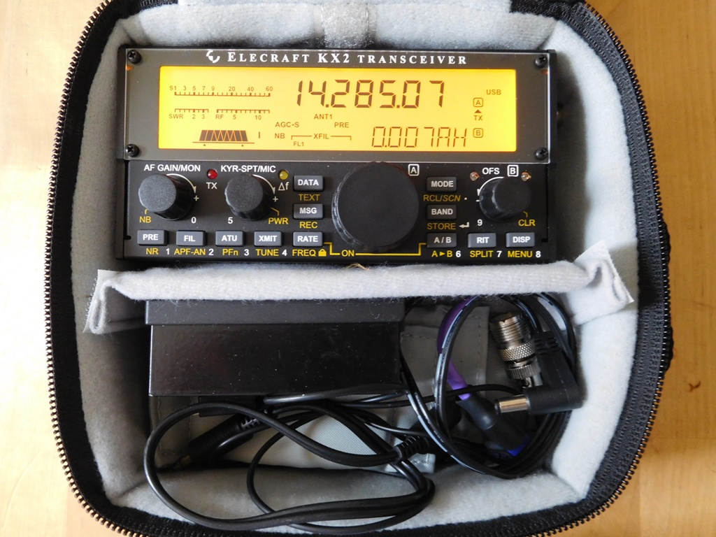
Elecraft KX2 in Lowepro CS60 case with Palm key and leads
Last month I visited the Ham Radio Fair at Friedrichshafen and spent some time on the Elecraft stand talking to Eric WA6HHQ (Elecraft Co-Owner) who demonstrated the KX2 to me and allowed me to handle it. I also attended Eric's presentation on Elecraft as part of the SOTA Presentation organised by the HB9 SOTA Group.

I came away from the event having decided to buy a KX2. I have used various transceivers for SOTA activating in the outdoors since I started doing it in 2005.

After the Brexit vote in late June when the UK £ fell by almost 10% and stayed at that level, it seemed a good time to buy the KX2 in case the price increased, so I ordered one from W&S the day after I got back to UK from Germany and received S/No. 194 the following day.  I am now awaiting the KXPD2 paddle key which is back order from W&S. Unfortunately I do not know when these will arrive in UK. I still have my Yaesu FT-857 to provide extra grunt when needed, my Youkits HB1B is my back up radio. I sold my LNR MTR3B and Yaesu FT-817ND now that I have the KX2.

So - how have I found the KX2 so far? Great - once I got it to work!  When I received my KX2 it had no transmit and no receive. On inspection the small plug connecting the BNC socket to the PCB had worked its own way out in transit. Easily fixed...

RTFM - Yes, essential. This is not like a typical Japanese transceiver, but once you get the hang of the multi function buttons and controls it's all fine, but I'm still learning - I've never used a piece of Elecraft equipment before so practice is still needed to become fully adept in the transceivers use...

I bought the larger Lowepro CS60 bag from one of the famous internet shops on line - a nice fit for the KX2 and bits and pieces. I bought a €5 Labtec headset / boom mic at Friedrichshafen. That headset seems to work very well and I am getting good reports on my audio quality, but I need to install a PTT switch in line, rather than using the XMIT switch on the radio. I have also had QSOs using the internal microphone which seems to be quite satisfactory.

On my first SOTA trip with the KX2 last week I used an external LiFePo4 battery. I have now built myself an internal battery pack which worked well on the SOTA trip I made to Scotland when I activated GM/SS-122, SS-140 and SS-179 on 27th July. The battery pack cost me £20 to make up. I used 3 X Sanyo 18650 3 AH tagged cells, a BMS battery protection board, shrink sleeving, wire and a DC barrel plug. The pack is a snug fit inside my radio. I bought a 12.6V protected charger for charging the battery pack. The battery needs to be removed from the KX2 to charge which I see as a negative feature, but Elecraft presumably see a fire risk if the Lithium battery pack is charged internally. 


Home brew lithium 11.1v battery pack for the KX2
Using the current and voltage monitoring features built into the KX2 I made some observations whilst operating yesterday. I was on the air from three summit locations, and completed 81 contacts in CW and SSB on 20m, 30m and 40m using a link dipole at 5m AGL. I do not use an ATU. These were typical rubber stamp contacts. I was actually on air, receive and transmit for a total of 132 minutes. The internal battery voltage at the start of my activity was 12.3V. At the end the battery voltage was 11.1V - as it should be, with the voltage on load showing 10.2V with the KX2 still indicating 10 watt output on the display using the TUNE button. The total power consumption for the whole activity was 1068 mAh. Therefore my internal battery should actually be less than 50% exhausted - amazing! 

Internal battery pack installed in the KX2
The only other thing I would note is that the radio was slightly off alignment by around 250 Hz when I received it. This was easily corrected using the calibration procedure detailed on page 37 of the manual. I have also preformed the latest firmware update as per the manual and the useful tips that Bob W3FPR put on the Yahoo Group a few weeks ago.

The features I like on the radio compared to the FT-817 are the lighter weight, size, clear display in sunlight, the smooth full break in on CW, the memory keyer, internal battery capacity and roven power usage allowing at least five average HF SOTA activations from the internal battery, the superior receiver performance and a modest increase in output power. Having now bought the KXPD2 paddle key I find that really useful... All I do when I arrive on a summit is plug in the antenna and make contacts - no power lead or external keyer to connect. I'm hoping to purchase the KX2 protective end panels from GEM products when they become available in the UK as the price of shipping them in individually from the USA is prohibitive. 

Friday 22 July 2016

SOTA Cycling - July 2016 - Gisborough Moor G/TW-003

The sun was shining as I left my driveway at 6.40am local time to drive to the village of Commondale - a start point for what is usually the walk up to Gisborough Moor G/TW-003, today was different, I was cycling and started off on the C Class road which goes over to Kildale.

G/ TW-003 summit is on a grouse moor which is policed by a fastidious gamekeeper, who I have met a few times. Today I was fortunate, I did not meet him - I was riding my mountain bike and I know he does not like the public cycling on the tracks that run over the moor. These rough tracks are just about suitable for land rovers and quad bikes. They are public footpaths, but not bridleways. The moor is access land.

I started my 2.8 mile ride up to the summit at 7.25am and was on the summit at the activation point 30 minutes later. I had to push my bike for about 200m after leaving the road when I became short of breath. 


I was carrying a lot more equipment to the summit than I usually do when walking. A 7 AH LiFePo battery, a 4.2 AH LiFePo4 battery, a small steel operating platten, a 50 watt VHF FT-1500M mobile radio, an Elecraft KX2 QRP HF radio, A 2m vertical dipole, an HF link dipole for 20/30/40m, a 5m travel pole and the usual extras like logbook, pencils, swiss army knife, rope and bungees. Some of the weightier things went into my saddlebag. The rest on my back in my rucksack. My arrival at the summit:

I set up on the 40m band CW to start with and GU3TUX was the first station logged on 7033 KHz. A few minutes later I was called by S2S specialist Juerg HB9BIN/P who was on Biet, HB/SZ-016, a 6 point summit. 40m was the best band for me today. After 19 QSOs on CW I made 5 contacts on SSB. 20m and 30m were dissapointing with a total of 7 QSOs on those bands altogether. I finished off on 2m FM with just 4 more contacts - it is much harder to make a large number of contacts on 2m FM in England during the week. Last Saturday on G/TW-001 (the nearest summit to TW-003) I made 22 QSOs on 2m FM, albeit that is a better site for VHF working...
After an energy bar and a drink it was time to pack up and head off back down the hill. I used the same route back as I believed that going that way I would avoid the gamekeeper, and I did. I never saw a soul at any time. Here I am about to depart the summit to ride back to my car:
Stats:

Distance driven return: 48 miles

Distance cycled return: 5.6 miles (Up time 30 mins @ 5.52 mph - Down time 15 mins @ 10.91 mph)
Total ascent both ways: 483 feet
35 Contacts on 2m (4), 20m CW/SSB (3), 30m CW (4), 40m CW/SSB (24)
QRV: 0721z - 0826z


Postscript added October 2016: The Dawes Mountain Bike has now been sold. I will be using a Focus "Hybrid" bike from now on, which is my normal knockabout shopping bike, quite adequate for forestry tracks and the like. I don't intend riding on terrain rougher than that in the future. 

Friday 8 April 2016

Two days activating in Wales - April 2016 - Gwastedyn Hill GW/MW-019


After leaving the parking place for Carn Gafallt a slow drive down a narrow lane took us back to the A470 south of Rhayader and to the other side of the River Wye. We turned left on the A470 and were parked up for Gwastedyn about twenty minutes after leaving Carn Gafallt. Time was getting on and we decided this was to be our last summit of the day, with MW-024 Rhiw Gwraidd being left for next time. We drove up to the start of a bridleway at SN 9901 6582 but found that parking was too restricted there, so we turned the car round and parked over 330m away on the side of the road to the south. 
Parking place for Gwastedyn Hill - the hill can be seen in the background
Once we climbed the first (steep) field and turned right a delightful path took us around the side of the hill to a cast iron gate at SN 9892 6650.

Climbing up the bridleway before turning right to go around the hill to the metal gate
A faint path through heather from there took us to the summit. The location was superb for VHF working and this was undoubtedly the best summit of our two day tour for views.
My friend Geoff 2W0NON arrives at the summit cairn on Gwastedyn
Looking to the western top 400m away we noted there was a beacon basket mounted on a plinth and a large conical shaped cairn. These were built to celebrate the silver jubilee of Queen Elizabeth II in 1977:

The late afternoons warm sun made the activation even more enjoyable and we had a little free time so I put up my HF dipole again and worked a few of the regular chasers on 40m CW before going QRT:
With seven more Welsh summits logged as SOTA Completes over the two days, including the completion of the South Wales Association,  I drove back to Bristol where I was based that week. 

Two days activating in Wales - April 2016 - Carn Gafallt GW/MW-040

After leaving Cefn Cenarth nature reserve car park near MW-039 we drove back through Rhayader. In a half hour we were in the Elan Valley driving on an unfenced road to the parking place for Carn Gafallt GW/MW-040.  This was on a bend by a barn at Pen y Castell, where a track heads uphill following the edge of a wood on the left side. 
My GPX track for Carn Gafallt can be downloaded from the SOTA Mapping Project

Once you leave the track the more eastward wider sweeping track on the map is the better one to follow as the heather is short and less dense on there. There is one trouser ripping barbed wire fence to climb out of the wood, or if you prefer, go further east on the track and avoid climbing it as we did on our way up.  Fortunate for me as I walked ahead of Geoff 2E0NON I got a good view of a Marsh Harrier for the first time in my life. The rare species bird was on the ground and took up to flight around 30m from me as I approached it. After qualifying the summit on 2m FM using 50 watts power I set up on 40m CW, however that only produced five contacts before we packed up and left.  The picture below taken by Geoff on Carn Gafallt shows what you need for a successful SOTA Tour in Mid-Wales. Belt and Braces... Here we deployed a Yaesu FT-817 transceiver with 5 watts output on HF to a link dipole, and a Yaesu FT-1500M transceiver with 50 watts output to a vertical dipole on 2m FM. Both aerials are mounted on a 5m travel pole: 

The walk to the summit due to the very deep heather, was awkward to put it mildly - we will not be returning here again.  It was almost 3.00pm when we returned to the car, so there was sufficient time left to drive the six miles to the parking place for the climb to our fourth summit of the day. This was Gwastedyn Hill GW/MW-019. 

Two days activating in Wales - April 2016 - Cefn Cenarth GW/MW-039

Cefn Cenarth was only 2.5 miles from our previous activation at Garreg Llwyd, however to reach the walk starting point we drove for 13 miles on a circuitous route to the north. On reflection later I realised we would have been better served by using the roads to the south, however the drive down the B4518 was most pleasant with the road at one point being lined with daffodils. 

A nature reserve has been created on the flank of Cefn Cenarth and as the map above indicates there are two ways to reach the summit. A car park with information board is located at SN 964759. The northerly path to the summit is more pleasant to walk as it is on grass, the southerly access being a graded track. We went up on the track and came back down on the path.  The forest on the summit had been felled leaving it full of brash. We set up again at the side of a fence and once again found 2m FM contacts hard to come by. We set up the FT-817 again on 40m and this time I made a handful of contacts using CW (Morse Code), the most notable contact being with Hans PB2T who was operating as HB/PB2T/P on a summit in Switzerland.  

Geoff on the summit 
My friend Geoff, operating as 2W0NON/P, persisted in calling CQ on and off on the 2m FM band. After 30 minutes he qualified the summit with his 4th contact:

The writer - just about to leave the summit of Cefn Cenarth 

Two days activating in Wales - April 2016 - Garreg Llwyd GW/MW-014

With breakfast being served at 7.00am at the Horseshoe Guest House in Rhayader, Geoff 2E0NON (driver) and I left the town at 7.45am and headed six miles north up the A470 to a gateway to the Bryn Titli Wind Farm installation. We parked here and walked the track up to the plateau of wind turbines just below the summit of Garreg Llwyd MW-014.

Access gate near the parking place adjacent to A470 road
It took 35 minutes to reach the summit. To stand on the actual summit you have to climb a barbed wire fence. Another classic case of inaccessible access land... So we climbed the fence and then returned to it so we could use it as a fixing point for the antenna.


Geoff Fielding 2E0NON on the summit of MW-014 Garreg Llwyd
It was early morning and with the summit being surrounded by higher mountains it did not favour VHF operation on 2 metres FM. After working our friend John MW0XOT nearby and Don GW0PLP in Cardigan, further CQ calls proved fruitless so the HF station (FT-817 & dipole) was set up on 40m SSB. My first contact was with Marcin SQ9OZM/P, who I was to meet on a joint activation in Poland later that month. 
After qualifying the hill as quickly as we could we packed and returned to the car just after 10.00am. 

Thursday 7 April 2016

Two days activating in Wales - April 2016 - Beacon Hill GW/MW-009


There is very little to be said about Beacon Hill GW/MW-009. We parked at spot height 406 on a lane that runs north to south. It was a straightforward 48 minute trek on tracks, rutted in places by the 4X4 "enthusiasts" that cause so much damage to our moorland. The weather was pleasant and our path followed Glyndwr's Way for a short distance.  As we were about to leave the summit after a successful activation a rainbow appeared, just to the left of Geoff's shoulder.....


We were fortunate again on VHF - with 9 contacts on 2m FM from a mixture of English and Welsh stations. After retrieving my car we drove to our guest house in Rhayader for a quick turn round, as we had arranged to meet fellow SOTA activator John MW0XOT, in a local pub at 7.30pm:

Writer Phil G4OBK - John MW0XOT - Geoff 2E0NON
We had a great meal with beer and wine in good company with (as expected) SOTA talk predominating the proceedings. It had been a good day, our first fairly dry one for some considerable time it must be said... three more SOTA Completes in the bag for me - hence the smile.

Two days activating in Wales - April 2016 - Great Rhos GW/MW-002

After leaving SW-035 Myarth we motored in both our cars to
Boggy moorland near the summit of Great Rhos
a cafe at Crossgates roundabout where we used the facilities and had a cup of tea. My car was left there and we continued to the start of the walk for Great Rhos, which we tackled from the north side by following the GPX track I took from the SMP provided by Gerald MW0WML.  We parked on the grass triangle at SO 173672 and set off along the bridleway for the hour it took to reach the highest point on Great Rhos, 660m above sea level. This was a pleasant walk, mainly on forest tracks until we reached the intake fence around 500m from the summit trig point where we entered boggy moorland. We were able to qualify the summit on VHF this time, and recorded 8 contacts each, which was pretty good for the middle of the day in the middle of the week. 
Heading back to the car and on to our next activation - Beacon Hill GW/MW-009

Two days activating in Wales - April 2016 - Myarth GW/SW-035

After waiting for the pheasant shooting season to end we finally got a chance to activate the last summit we needed to complete the South Wales Association - GW/SW-035 which is known as "The Myarth" by the Glanusk Estate and not Myarth as it is referred to in the SOTA Association Manual and on OS maps... 

GW/SW-035 Myarth

Written permission to access the summit granted, I met up with Geoff Fielding 2E0NON near Crickhowell, and we made our way in his car to Gliffaes Fach SO 164203, where there is room to park one car:

Our route - the GPX track is available in the SOTA Mapping Project (above)
and (below) timber extraction on the track going up Myarth


Timber extraction was taking place on the hill and the tracks were muddy and rutted. We were on the summit within 40 minutes, calling CQ on the 2m FM band for 10 minutes or so and with no callers, despite running 50 watts of power into a vertical dipole. We thought that may have been the case so an FT-817 on HF was deployed on the 40m band with a dipole, resulting in 17 contacts with EU stations on SSB and CW. The only UK station worked was our friend Terry G0VWP who lives in York. Geoff operating as 2W0NON/P on Myarth:


After less than 20 minutes on air we packed up and headed north into mid Wales to activate two more summits that day.

Wednesday 24 February 2016

SOTA GM/SS-114 Greatmoor Hill and GM/SS-106 Cauldcleuch Head

I'm running out of unique Marilyn Summits I haven't climbed which can be reached there and back by car within a fiteen hour day. Due to the expense of travelling, even though fuel is cheaper than it was previously, I cannot justify a solo trip just to visit one summit - there has to be two to make the day worthwhile.  From my home in Pickering North Yorkshire, there remains a few places in the Scottish Lowlands where two summits are reachable within a day. The hills and mountains of North and Mid Wales I need to climb are now unreachable in a day and require an overnight stay. 

I set out for Newcastleton in Roxburghshire at 5.45am, stopping off at the Tesco Store in Carlisle for a comfort break and "coffee to go" from the Costa Coffee shop there. The short departure from the M6 cost me time as I got stuck in the Carlisle rush hour traffic for ten minutes. Next time I will likely use the Motorway Services a few miles south instead. The stop allowed me to give Treacle, our cross Lakeland / Border Terrier who was accompanying me on this adventure a comfort break. 
The heart shaped route taken - a GPX file is now available from Viewranger or the SOTA Mapping project
At 9.15 am I reached the parking place for my walk at Braidlie Farm - grid reference NT 477966. This is just four miles NNE of the strip village of Newcastleton. The temperature was -2c when I set out at 9.30am on a pleasant dry air morning with clear views to the fells above me. The moor was frozen with patches of snow remaining in places. It wasn't surprising there was not full snow cover, as this has been our warmest winter since 1910. 
Greatmoor Hill - thirty minutes into my walk with an hours walking left to reach the summit
Today I am using the Viewranger app on my phone to aid navigation. I started using Viewranger in the Czech Republic in September 2015, and have been slowly getting to grips with it ever since.  I have been using various Garmin GPS devices since 2006. Last year I also trialled a Memory Map TX4 Android GPS / Smartphone which proved unsuccessful as the device I had was not waterproof, despite claims to the contrary. In November I purchased a Vodafone Ultra 6 phone. This cheaper phone (£115 outright) is not waterproof (unlike phones such as the latest Moto G) so from the lesson learnt when using the TX4 unit I bought an Aquapac waterproof case to go with it. The Aquapac would not be needed today... In addition I always carry map and compass and my trusty Garmin GPS62s as a backup. This GPS is carried in my rucksack now I use Viewranger and is also recording my route. I generally download the Viewranger Ordnance Survey Map tiles in 1:50K and 1:25K for the areas I walk from Viewranger and today was no exception. This means the mapping runs independently of the mobile network as the OS maps are stored on the phone itself. The previous night I had downloaded three 1:25K tiles and one 1:50K tile which more than covered the area of interest at minimal cost.  With Viewranger on an Android phone the app is installed into the phone memory and the mapping goes on to the memory card, which in my case is 64 GB in size, so I have plenty of room for the mapping I install for the various european countries I visit every year. Most of the maps on my phone were downloaded from Viewranger, and these are provided free of charge under Creative Common Licence from the Open Street Map project. 

So, let's get back to the walk and my Summits On The Air activation...

This was good and easy moorland walking with sheep trails and quad tracks to follow. The frozen ground helped and my boots stayed clean. Treacle was thoroughly enjoying herself, taking advantage of the occasional patch of frozen snow to grab a mouthful, something she seems to enjoy doing. She looked very smart today in her tartan jacket having recently had a haircut:
The summit of Greatmoor Hill GM/SS-114 offered me some far reaching views - the Eildon Hills near Melrose always stand out well in the region due to their characteristic twin humps:

Today I was carrying the Yaesu FT-817 HF Transceiver, with a 4.2 amp external LiFePo4 battery running 5 watts output. My antenna was an inverted vee dipole for the 40m, 30m and 20m bands mounted on a 5m fishing pole. As well as a trig point and large pile of stones there was a fence running across the 599m high summit which provided a convenient fixing point for my antenna pole. There was also a well crafted stone cairn on the other side of the fence.

The 7th SOTA radio operation of Greatmoor Hill got underway then by GM4OBK/P (my official Scottish callsign) at 1115 am when I made a contact with Mike DJ5AV in southern Germany. In 40 minutes 42 stations were logged, with 26 contacts in Morse and 16 using Voice communications on the short wave bands of 40m, 30m and 20m. During the activation I made contact with two other summit stations. This was DL8DXL/P Fred on the summit of Rotstein in Germany, and GW4VPX/P Alan who was on Mynydd Troed in South Wales.  I believe that running an inverted vee out over the line of a metal fence enhances the signal and this proved to be the case today...

Moving off Greatmoor Hill I made my way down Starcleuch Edge to a col at Windy Swire. From there it was a simple matter to follow the fence up Windy Edge to my second summit of Cauldcleuch Head GM/SS-106, which at 619m was 20m higher than Greatmoor Hill. 
GM/SS-106 Cauldcleuch Head - a less interesting summit with just a gate and fence
This summit has only been activated four times since Jack GM4COX came here for the first activation in May 2005, and today Jack was on the other end of the line when we made a contact on the 40m band in CW. This would have been a "SOTA Complete" for Jack, sadly it was not for me as I missed him when he was operating here in 2005! So, if you are a SOTA Activator reading this and you are coming here please let me know so I can make a contact with you from my home station. The other operators who have been here are Andy MM0FMF (2014) and Gerald GM4OIG with Paul GM4MD (2013). After my activation exactly 100 contacts had been made from the summit of which 46 were mine, made today at an average rate of one contact per minute. I was lucky to arrive at the right time to again contact my two SOTA summiteer friends on the day from here when I again made contact with Fred DL8DXL/P on DM/SX-047 Lobauer Berg and Allan GW4VPX/P on GW/SW-015 Mynydd Llangorse. 
A relaxed Treacle on GM/SS-106 Cauldcleauch Head
I had made my way here by following a pre-programmed route I had created the my.viewranger server website on my PC, which I had imported into the Viewranger App. Now it was time to work out my own way down back to my car "on the hoof" so to speak, via the shortest route possible. A study of the land contours and map features showed that once again I could follow a fence. This ran over Muckle Land Knowe from where I could walk across the flank of Little Land Knowe.  This route would then take me down to the fords at NY 4732 9765. The way was a little tussocky to start with but once I got to around the 500m level the ground became pretty smooth. From Cauldcleuch Head to car took me just 80 minutes and I reached the end of my walk just after 4.00pm with plenty of daylight remaining.  It had been a superb day's hillwalking with amateur radio and Treacle for company. Out of interest I checked the power remaining in my phone battery which had been on all day, with Viewranger and GPS running and the screen off unless I was viewing it. The phone had also been used to self spot using the Rucksack Radio Tool App on the Vodafone network.  I had 30% battery power remaining.

From Braidlie Farm I turned the car round and made my way back to the A7 via Newcastleton and Canonbie. The M6 took me to the KFC in Penrith for some food and I arrived home in Pickering, North Yorkshire at 8.00pm. 

Distance walked: 9.2 miles
Walking time: 3 hours 52 mins
Time spent on summits: 2 hours 46 minutes
Total ascent: 2300 feet
HF Contacts completed: 88  
Miles driven: 318
Length of day home to home: 14 hours 45 mins
Mobile signals on the Vodafone network on both summits 100%

Refs:
Details and GPX Track on Viewranger
GPX Track in SOTA Mapping Project 
Summits On The Air Website: SOTA
Hill Bagging.co.uk Website