Wednesday 1 December 2021

SOTA GM/SS-289 White Hill 01-12-2021

Hightown Hill (formerly GM/SS-273) is an important summit for me. I was the first person to activate the summit and additionally, it was my very first SOTA activation on 21 June 2005.  A re-survey by Alan Dawson (Author of The Relative Hills of Britain) of Hightown Hill had taken place, when it was established that nearby White Hill was 20cm higher, therefore the Marilyn status was transferred to White Hill GM/SS-289 for the purposes of SOTA, on 1st December 2021. I wanted to the the first activator of White Hill which is why I stayed overnight in Annan on 30th November 2021, to ensure I had early access at first light. Having dried out my gear overnight from my wet activation of Deuchar Law the previous afternoon, I left my guest house in Annan at 06:45z after a cup of tea and drove out towards the village of Tortherwald and then north to the parking place for GM/SS-289 White Hill.  I slyly alerted the activation later than I usually do - just prior to leaving the Annan guest house on the day, to help ensure that I would be the first to activate the "new one"... As it was dark when I started out I parked away from Hightown Farm as I wanted to avoid contact with barking dogs and farmers. So I parked roadside at the side of Bruntshields Wood NY 028825 and walked up the road to a gate at NY 029832. From there I walked over stock free fields and through open gates to the summit:

©Crown copyright 2014 Ordnance Survey Media 2014

On arrival I got out my FT-65 handheld with RH-770 whip and worked Geoff Harper GM4WHA who lives in Annan. 59 reports were exchanged both ways and the summit was activated! I've known Geoff since I started activating SOTA and WOTA and we've activated and walked the Lakeland Fells together several times, so it was great for him to be the first chaser to work White Hill. As Geoff headed off to work I set about assembling my HF station. 60m was open - but not wide open to UK. The skip was long and several NYSA members were unable to hear my 10 watt signal. (NYSA is the (unofficial) North Yorkshire SOTA Association!). I did scrape a contact with Victor GI4ONL who's CW signal had a rough echo sound it - decidedly auroral, so maybe it came from a reflection to the north. Finally NYSA member Terry G0VWP (York) was worked before I moved to the 40m band. It was a cold morning, but dry with excellent views across to the M74 motorway and the wood processing plant in that direction. The trig point on Hightown Hill was close. The depression that is Whitehill Moss in between the two hills, drops by around 30m:


After sitting for an hour in significant wind chill I took a selfie and decided after my final calls on 20m CW that I would depart before hypothermia set in, however I finally re-connected my dipole links to the 60m band and moved to 5398.5 KHZ in an attempt to worked the remaining NYSA members who I knew were still looking for a QSO for the all time new one... Sure enough the skip had shortened, and Pete M0HQO (Pickering) and Nick G4OOE (Scarborough) were both logged with 59 reports both ways. I then logged MM0GGI, G0RQL and G8XDD (Not ADD), finishing with 41 QSOs. After my soaking the previous day on Deuchar Law and the cold experienced on White Hill, I'd felt I had achieved what I came to Scotland for and drove south to Tesco Carlisle for an all day breakfast before driving home. I must mention F5JKK before I go, as Eric worked me on every band I used: 60m, 40m, 30m and 20m on SSB and CW!

Tuesday 30 November 2021

SOTA GM/SS-144 Deuchar Law 30-11-2021

 
The route taken

I travelled up to Scotland intending to be the first to activate a new summit - this was White Hill GM/SS-289, however to be sure of this I needed to be in the area near Dumfries, early morning on the 1st December. I booked a guest house in Annan for the 30th November and activated Deuchar Law that day, before going to Annan in the evening.
 
It was St Andrews Day, a public holiday in Scotland and the first qualifying day for the SOTA Winter Bonus in Scotland where special dispensation had been granted to earn the bonus a day early and I believe that I was the only activator to take advantage of this unusual situation, so my activation was worth five points rather than the usual two...

The weather was changeable and wet in the last week of November and I was uncertain whether this activation would actually take place at all. After studying weather forecasts I decided to leave Yorkshire in mid morning and hoped that when I reached the area north east of Moffat that the weather would be dry enough to proceed to Deuchar Law (543m ASL). Indeed it was dry enough to set off when I arrived at the parking place at Glenlude 326m ASL, (NY 312297) for my walk from the B709 road, at 1400z. With darkness just over two hours away I knew that my headlight would be needed for the return walk...

Parking place in lay-by above Glenlude

It was a shade under two miles and around 850 feet of ascent to the featureless summit of Deuchar Law, a slightly easier walk than the climb to GM/SS-029 Broad Law nearby, which I activated in August with Pete M0HQO. It was mostly grass to the summit, with the final half mile or so after the fence rather rough ground, but not so bad. It took me just an hour to reach the highest point of Deuchar Law, and I was on the air on HF working my good friend Nick G4OOE in Scarborough at 1530z using the 60m band (CW).  I worked Nick again on SSB, as well as my near neighbour in Pickering, Pete M0HQO (CW), and finally Victor GI4ONL (SSB) before moving to 40m CW to work nine more European stations.  The weather was on the turn when I arrived, wind was around 20 mph and rain threatening. I found a hollow in the ground a few meters down from the few stones marking the summit and pitched up my golf umbrella there to keep the rain off me and my KX3. There was nothing to fix the aerial pole to on Deuchar Law, so I used my guying ring. A link dipole was deployed as an inverted vee on the 60m and 40m bands:


After twenty minutes of activity and eighteen contacts it started pouring with rain. The headlight came in at that point and I packed up the gear while sheltering under my brolly. The walk back was decidedly wet in torrential rain and unpleasant but it was worthwhile, as I secured another SOTA Complete on my way to the 1000 target I am aiming to reach in 2022 before I turn 70... 

The drive to my guest house in Annan in the pouring rain was uneventful. After a change of clothes there I headed back out into the rain to have a lonely Indian meal in the dimly lit Sitar Restaurant - I was their only customer!

Monday 13 September 2021

GM/SS-236 Corse Hill (Whitelee Wind Farm)

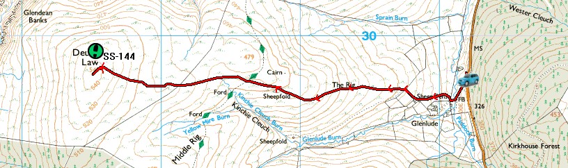
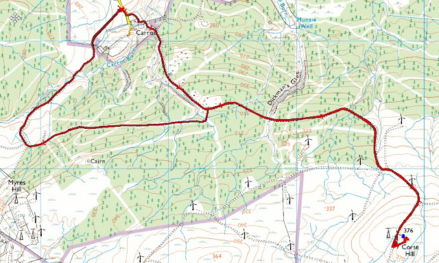
It was a 32 mile, 55 minute drive from Blaeloch Hill car park to the hamlet of Carrot near to NS 576483, my start point and parking place for the ride to the summit of Corse Hill. The Sat Nav took me via Dalry and Stewarton.  I encountered a small diversion due to a road closure on the way. At Carrot there was room to safely park at the track junction.
Bike route out and return via unmarked track through NS 575473 (2014 mapping
Just beyond the track junction a bridleway goes left to avoid the homes in the hamlet. I was trying to ride my bike all the way to the summit, but before I reached the track at NS 579581 I had to push for a bit due to a heavy gate and a rough section crossing the burn. It took 22 minutes to reach the summit trig point, which was over a distance of 2.4 miles. A good time saver compared to walking and less tiring by using the e-bike again, as I did a few hours earlier on Blaeloch Hill.
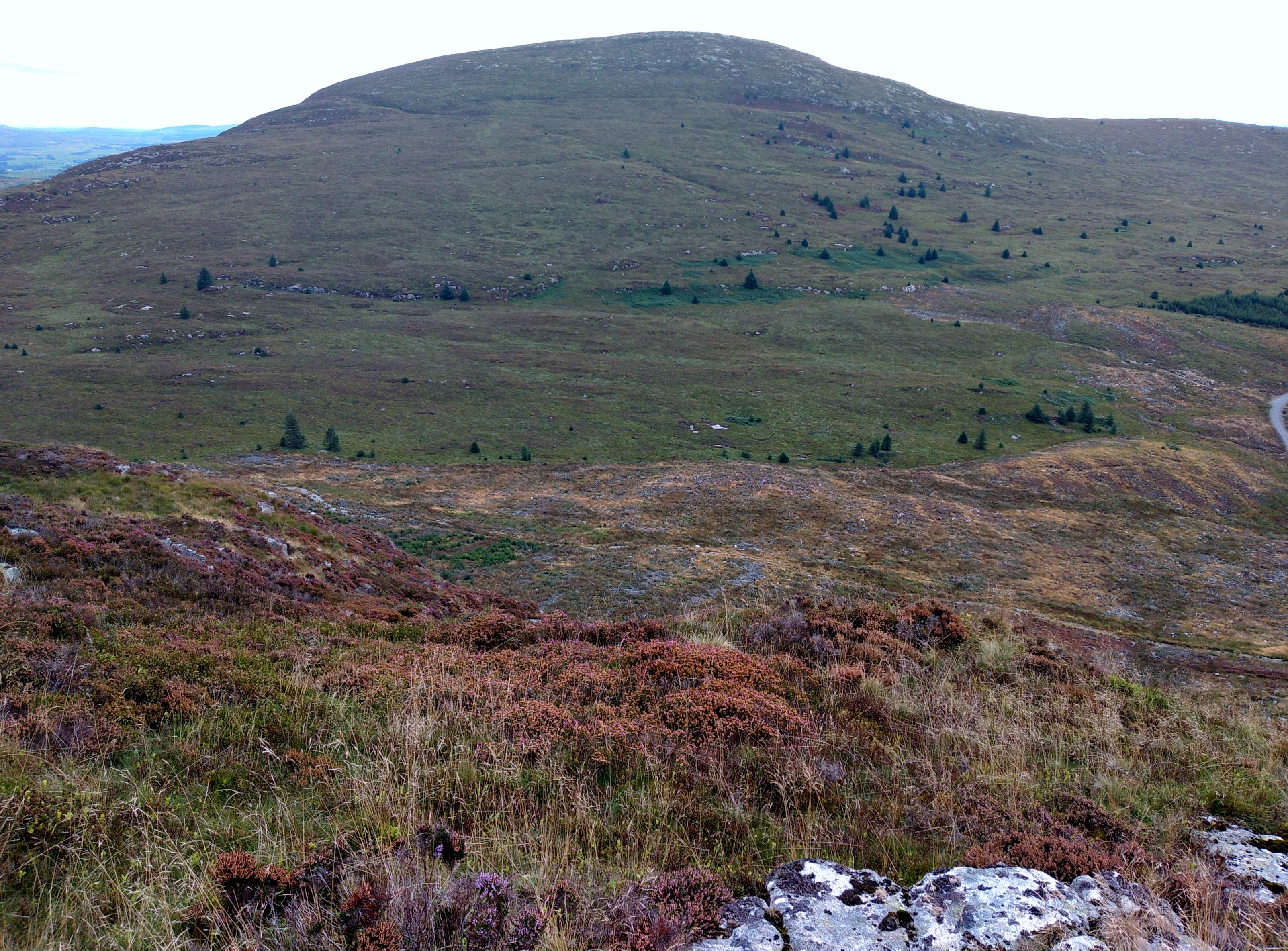
It was 1600z when I got started on the 60m band. My friend Nick G4OOE in Scarborough was first in the log on the international part of the band - 5354 KHz in CW. Propagation was stretching out as far Italy and Fabio IK2LEY was again logged. Time was short as I had a 220 mile drive back to North Yorkshire, so I restricted my acitvity to 60m CW/SSB and 40m CW. There was no apparent interference from the enormous Whitelee Wind Farm, which I was in the middle of, unlike my experience earlier in the month on Meikle Says Law GM/SS-148, where the interference, especially on 60m, was dreadful. The only noise I heard was the movement of the turbine blades, quite spooky and the feeling of being watched by a webcam  close to the trig point which was moving about and probably capturing my activity. Between 1600z and 1627z I logged 24 stations. After packing up I made a short and very amateurish video of the summit, which is now on YouTube:
 

To save getting off the bike on the way back I took a longer route on a track that was not on my map. It brought me out where I wanted it to by my car. I had a reasonable drive home, discovering that the KFC outlet on the A66 roundabout at Penrith was now closed. The Burger King on the other side of the M6 was open but had toilets "closed for cleaning". A likely story.... I didn't buy from there. So I drove into Penrith by the railway station, for a McDonalds Burger, which was barely warm. I shan't be going there again. Returning to the A66 the Appleby bypass was being resurfaced, so a convoy system was being deployed at night to safeguard the workers. Sutton Bank near Thirsk was closed for two weeks, causing a further delay. I arrived home in Pickering at around 2300 local time.

Over the two day trip I had four SOTA Completes out of the five I had hoped to do, 103 SOTA QSOs, 11 S2S. This takes me on to 940 Completes. 548 Miles driven on the road trip.

I hope to get back over the border this year before it gets too cold - but that's after a 10 day SOTA Tour with Victor GI4ONL in Northern Portugal in early October. 

SOTA GM/SS-236 Corse Hill 13/09/2021

After leaving Blaeloch Hill GM/SS-220 I made my way to my 3rd and final summit of the day, which was Corse Hill GM/SS-236. This was another summit on the large Whitelee Wind Farm to which I could cycle to the top. 

I parked up on a road junction near the hamlet of Carrot where there was just room to safely leave my car (NS 576483). Here is my cycle route out and back: 

©Crown copyright 2021 Ordnance Survey Media 018/21
Apart from a short walking section at the north side of Carrot it was a easy ride on well graded tracks to the summit which took just 20 minutes. I operated at the trig point in view of a CCTV camera on a monitoring mast close to me. I did not detect any intereference from nearby wind turbines on the 60m and 40m bands. 


CCTV Camera adjacent to the trig point

I operated from 1600z-1627z and made 24 contacts before "pulling the plug". It had been a long day with three SOTA Completes in the bag but I still had over 200 miles to drive home, so the activity was neccesarily brief.

I decided to take a slightly different route back to the car, which meant I did not need to get off my bike at all. I rode south and then west from the junction at NS 583474 as shown on the map. After filling up the car at a supermarket on the outskirts of East Kilbride I made it to Penrith for some food, reaching home just after 22:00z. 

GM/SS-220 Blaeloch Hill (Kelburn Wind Farm)

A 55 mile drive from Grey Hill via Ayr and Irvine brought me to the parking place by the A760 near Largs, for GM/SS-220 Blaeloch Hill, on which Kelburn Wind Farm is located. The parking place is located adjacent to The Clyde Crematorium which looked quite new. There is no vehicular access to the site for the public, however a bridleway gate is fitted by the locked gate for horse riders, cyclists and walkers, who are encouraged to access the site for leisure purposes.

Parking place for the public to use - the Clyde Crematorium can be seen to the left

The plan was to activate this summit via bicycle with the last section over the moor on foot. One way this was two miles by bike and about 600m on foot to reach the highest point which was "trigless". The ride up on my Bergamont e-bike took me 14 minutes and the walk just 7 minutes. I bought the bike over two years ago and apart from one SOTA ride to activate Round Hill G/TW-001, it has just been used for social riding around where I live. The bike is standard as it came out of the factory, except I fitted a saddlebag and a pair of Schwalbe Smart Sam tyres, which are more suitable for the types of tracks and terrain I need to ride on. I carry the radio, antenna and battery in the saddlebag and transfer it to the rucksack when I leave the bike. I was pleased to finally use the bike to bag some unique Scottish SOTA Completes. As a very active Chaser the only contact I had with SS-220 was with Helen MM0YHB/P in July 2014 on 40m SSB - this was despite the summit already having been activated 32 times prior to my visit. After the ride up I locked the bike up on the ground near the turbines and proceeded on foot to the small cairn on the summit, which was able to support my 5m pole and link dipole:
 

HF band conditions were fair - 25 contacts were accrued in 30 minutes on 60m, 40m and 30m in CW and SSB. I cut the activation short as I had another wind farm summit to go to - Corse Hill GM/SS-236, which is a few miles from East Kilbride, and a 38 mile drive from my location. Once again, Victor GI4ONL was my first contact:

GM/SS-256 Grey Hill - September 2021

From my digs in Creetown I drove for an hour to reach a good parking place for activating Grey Hill GM/SS-256. It was an enjoyable early morning drive via Newton Stewart and then north on the A714 via Barrhill. There must have been over 20 Wind Farm installation staff in their oncoming vehicles going to work on the latest project in the area, and they weren't hanging around... I parked on the backroad between Pinmore and Lendalfoot near Knocklaugh Farm and walked down the hill to start my walk. A field gate 100m off the lane takes you on to open fell and there was just one wall to climb to reach the summit. 
Parking just above Knocklaugh Farm

The field gate at NX 1712 9188 gives access to the flank of Grey Hill from the south

Good route to SS-256 - there were some quad tracks to follow higher up

The view from the top towards Ailsa Craig GM/SS-246 took me back to the memorable trip organised by Jimmy M0MGY and his Dad Tom M1EYP in August 2009:


I pegged out my link dipole for 60m-20m into the strong wind, which was coming from the south. It's quite surprising when the land falls away like it does on both sides of Grey Hill and the dipole ends fall close to the ground on a 5m pole, how well you can progagate a signal on HF - my best DX with 10 watts CW on 20m was Indonesia, with a contact with YC2VOC - operator Galih who penned me this message after our QSO, very nice:
I started operating on 60m at 0822z. My friend Victor GI4ONL was waiting for me on 5354 KHZ CW. I finished at 0907z on 20m CW with another good friend, IK2LEY Fabio (I always think of ILKLEY whenever I hear Fabio's call - a town in West Yorkshire!).  There were a nice handful of S2S contacts including Armin EA/DL6GCA/P on his holiday in the Navarra region in the Basque area of Northern Spain. 40m SSB was dissapointing with only one QSO with GM7NZI Ray, who lives near Glasgow, then there were unanswered CQ calls on a clear frequency. Yet minutes before I had scored 11 contacts on CW on the same band. 
Grimacing in the wind on Grey Hill after packing up my station
It was time to move on so the DXer headed back down the hill after 34 QSOs.  There were two more activations planned for later in the day some distance away from this one so I had to get going...

At the gate near the road I feasted on a few ripened blackberries before getting back into the car and driving north to Largs for my next summit.

Sunday 12 September 2021

GM/SS-170 Black Craig of Dee 12/09/2021

The summit is also known as Cairnsmore by some - but as we also have Cairnsmore of Fleet (GM/SS-065) eight miles away, I'll stick with the alternative name for the summit of Black Craig of Dee. My advice for this summit is stay away unless you have to. As a SOTA Completist I felt I had to go there - but there were other summits in the area offering more points that would have been much easier to reach than this meagre one pointer. My choice of route was bad for sure - I wish now that I had noticed the route notes of Gerald G4OIG on the SOTA website before I went there rather than after... In 2007 Gerald wrote that he used a parking place on the Raiders Road beyond The Labyrinth and walked from there, rather than using a bike as I did, from the Clatteringshaws Reservoir Visitor Centre. Here is my route:


The 3 mile route took me almost 3 hours to negotiate, despite using my bike for the first mile! Here I am on the car park (£3 for the full day) preparing to set off at 10:20am on the Sunday of the G/LD weekend, in the hope that from GM/SS-170 I would work some of the Lakeland stations across the Solway Firth, which was 23 miles south of my summit:

My plan was to ride to the Rocks of Laggan (see map above) lock my bike there and cross the Nick of Benniguinea to reach the summit via a wide ridge. I chose a bad route for the bike section though and should have continued on the graded track to the hairpin at NX 565766. I could then have ridden up to the Rocks of Laggan no problem. The rocks are just below the radio mast on Benniguinea. However, I turned right at NX 559764 and went south - thinking the track was a goer on the bike. At around NX 561760 the track became an unrideable path, so after pushing the heavy e-bike uphill for a few hundred metres it was ditched amongst the bilberries and locked up:
Bike dumped at NX 562760
It was 10:44am when I rejoined the graded track at NX 563761. I walked the rest of the way to the summit, reaching the top at 13:10pm!  It wasn't so much a walk as a stagger - stop - rest - stagger - fall over - stop - rest - stagger - fall over. It took me almost two and half hours to stagger the two miles to the trig point due to the horrible terrain. Coming back was a little easier, but not much, and I never saw a soul all day. The ground was almost pathless after leaving the track near Benniguinea, amongst tussocks, bilberries, bracken and marsh grass. I've activated the majority of summits in Dumfries and Galloway region but this was undoubtedly the hardest for me, although my level of stamina and overall health is now diminished from what it was a few years ago.
Clatteringshaws Reservoir from the flank of Benniguinea
Black Craig of Dee from the flank of Benniguinea - it looks easy but isn't

Summit of GM/SS-170 Black Craig of Dee (Cairnsmore)
The trig point had the theodolite fitting cap removed so the hole provided an orifice for my 5m pole fitted with 2m vertical dipole. I was carrying a "pocket rocket" - the old Yaesu FT-1500m 2m FM radio with a 4.2 Amp LiFePo battery, which I flattened whilst running 50 watts over the 50 minutes I was on the air, making 21 contacts. The log contained only four G/LD activators though, which was a little dissapointing. Using the higher power meant I was able to work M0NOM/P, M0JKS/P G4OOE/P and G3TQQ/P in the southern part of the G/LD area. The best DX contacts were another Mark - G1PIE who lives between Chorley and Preston, an area I know well. Then John GW4ZPL came in, who lives near Anglesey. Mark M0NOM/P was on Whitbarrow Scar, who was not as strong as the other G/LD stations. Hardly suprising when you look at the path profile, 78 miles is not exceptional - but the path goes straight through the large lump of Great Gable G/LD-005:
GM/SS-170 Black Craig of Dee left - G/LD-045 Whitbarrow Scar right

The best part of the day was logging contacts - here is my log:

I was hoping to go to nearby GM/SS-181, Fell of Fleet by late afternoon, however as it was 14:45pm when I left the summit the alert was deleted and I took the re-ascent over Benniguinea at a slow pace, lying down from time to time amongst the sweet and tasty bilberries.
Before packing up my gear on GM/SS-170 Black Craig of Dee
After collecting my bike and enjoying the one mile ride down in just a few minutes, I reached the car at 16:53pm before heading to my accommodation in Creetown, where I was able to cook myself a meal and enjoy an Amstel lager, purchased from the nearby convenience store - open until 8.00pm on Sundays.

Analysing my day I questioned my reasoning to continue SOTA activating after such a gruelling day, with over 200 miles of driving, the cycling and the gruelling walk. Fortunately the next day, when I ventured north, was much more enjoyable and productive and this restored my interest in continuing with what is three hobbies combined into one in what we all call SOTA. 

Tuesday 31 August 2021

GM/SS-148 Meikle Says Law - August 2021

Our departure day of a 6 night stay near Edinburgh, and the day after the English late summer August bank holiday. I wanted to drive back to North Yorkshire on the east side of the country avoiding the Penrith A66 route and the Lake District traffic. The most appropriate unique summit was GM/SS-148, Meikle Says Law, which I have avoided in the past owing to its fairly long walk in. There was ample roadside parking near to grouse butts at NT 612636. The walk starts with a steep descent to Faseny Water, Faseny Cottage and a black stockholding barn, pictured here on our way back:
We forded the burn, as the water on the day was shallow enough, although there was a footbridge 150m east of the crossing that one could have used. A track goes up on to the moorland from here which peters out around NT 590629 and from then on its sheep tracks and a faint rough path in parts to the summit at 535m ASL, where there is a trig point. Although the picture above shows fair weather, it wasn't like that 3 hours earlier on our ascent when we were had a "dreich day" up until the time we lifted the umbrella and headed back down the hill, when the wind farm near to the summit exposed itself. 

It took us 72 minutes to reach the summit, over a distance of 2.75 miles. Judy had her walking poles, I decided to carry a golf umbrella which proved very handy for settling down underneath with my station and Judy's book when we were on the summit:

We weren't intending to stay long in such miserable conditions as we had a long drive home and an arrangement to collect our dog Treacle from the kennels before 6.30pm. The 60m band did not sound very good, with QRN to S7 eminating from the wind farm (I assumed) nearby. Terry GM0VWP/P who was on a Shetland summit was waiting for me to start up on 60 metres using 5354 KHZ. We got the S2S no problem. I followed this with the usual supects, including my friend Nick G4OOE in Scarborough on both CW and SSB. When 60m dried up I went on to 40m where the QRN static was not as noticable, but it was there all the same. I finished my final 16th QSO on 2m FM with Christine GM4YMM, having earlier worked her other half Ken GM0AXY on 60m SSB. 
Packing up we headed back down much the same route - taking us almost the same time as it took us on the outward journey.

Haste ye back to Scotland.... and I will, and soon enough, after what had been an enjoyable short break with some mostly good and a couple of not so good walk routes.  

Monday 30 August 2021

GM/SS-154 West Lomond and GM/SS-198 East Lomond - August 2021

On our penultimate day in Edinburgh it was worth driving for an hour across the Forth Bridge into Fife to get two easy completes. The two summits were catered for well with free car parking, picnic tables and public toilets on both. We took the easy option and drove round to the East Lomond car park at NO 252058 after our lunch, which reduced the walk distance somewhat, however one could easily activate both summits from the West Lomond car park at NO 227061. This map shows the summits and also the nearby GM/SS-187 Bishop Hill, a summit I plan to visit later in 2021:

It took exactly one hour to reach the summit of West Lomond, on a good path over a distance of 2.5 miles. My new boots were extremely comfortable I'm pleased to say.  They are over 300 grams lighter than my leather Scarpa's. This made quite a difference in my speed and my stamina.
A grey day on West Lomond - yet there were many visitors on foot and mountain bike
I started operating with my FT-65e handheld and whip and worked Ken and Christine (GM0AXY/GM4YMM) straightaway followed by GM0GAV, GM0VEK, GM6ZAK and MM0JJQ. HF conditions were pretty good too, with 45 contacts completed in less than an hour, including my friend from York, Terry, GM0VWP/P who was staying in Shetland on his holidays. We made S2S from both West and East Lomond as Terry remained on GM/SI-177 for several hours. K4DY called in at 1141z on 20m CW. Leslie is one of the regular USA stations that can be be worked from the UK with QRP power. I was using the usual KX3 at 10 watts and inverted vee at 5m AGL. 

We walked back to the car park to have our lunch and then drove through Falkland (Nice looking touristy village - we must return) to reach the nearest parking place for East Lomond, GM/SS-198. 

East Lomond

A short 18 minute walk took us to the topograph and the highest point on GM/SS-198 East Lomond:

Topograph on East Lomond GM/SS-198

On 2m FM using my cheap FT-65e, I was getting a lot of de-sense from the relay station by the car park making difficult copy of the callers. Moving behind the top of the hill helped and I managed to work the same GM guys that I worked earlier on from West Lomond! Maybe I should have kept hold of my old VX-170 and FT-270 handhelds, but the FT-65e has a better battery pack and is lighter. Condx were typical late afternoon on HF - fairly poor and after 30 minutes I packed up. Judy XYL came up to the summit with me, but having climbed it, went back down before I went on the air:
This was our last full day in Edinburgh - we planned to activate Meikle Say Law GM/SS-148, near Duns on our way back south the following day...