Thursday, 21 February 2019

Bengray, White Top of Culreoch and Pibble Hill - 21 Feb 2019

I had planned to activate three summits in the Borders area over two days this week, however accommodation at the Tushielaw Inn near Selkirk was unconfirmed the day before I travelled so I decided to go west into Dumfries and Galloway and activate some unique summits there. I booked an accommodation in the right place the day before I travelled which was good and cheap for the solo traveller, so off I went...

Timing
Depart Pickering: 0550z
GM/SS-238 Bengray start walk:10:03 arrive:11:04 Depart:11:48 return car:12:34
GM/SS-245 White Top of Culreoch start walk:13:09 arrive:13:43 depart:14:41 return car:15:04
GM/SS-232 Pibble Hill start walk: 15:41 arrive:16:29 depart: 17:11 return car:17:54
As I expected, this was a long day, however my overnight stay in Creetown was only a few miles from the parking place for Pibble Hill....

Equipment: Elecraft KX2, link dipole on 5m pole, Yaesu VX-170 RH770 whip

GM/SS-238 Bengray 
The C class road north from Gatehouse of Fleet led me to the parking place for Bengray at Laghead Bridge. A core path leads from here to Loch Whinyeon.

I used the core path for about a half mile before heading off on uncharted territory towards Bengray over the top of Benfadyeon. I used occasional quad tracks before reaching the fence and wall where I turned up to follow right to the highest point. I stopped at the wall outside of the wood and well within the 25m drop activation zone - noting that the contour spacing on the 25K OS map in this area is 5 metres. 

I made one single contact on 2m FM - with Derek 2E0MIX  in Cumbria. This was not surprising as I was using a VX-170 with the RH770 whip. 40m was rather disappointing and I closed down after 13 contacts on that band:
Visibility was poor in mist both ways and I returned via a slightly different route avoiding the climb over Benfadyeon. Looking back a better route may have been possible via Burnt Mound:
A short drive took me to the track leading to SS-245 White Top of Culreoch.

GM/SS-245 White Top of Culreoch

An excellent graded forestry road with no restrictions or gates took me to NX602624 where there is a parking bay and turning point, pictured above. 

The fence and wall was followed until the summit was neared where the fence was climbed at a strainer post. The forest was felled some years ago and as the top was neared the remaining brash was encountered for a short distance.
A call on 2m with the handheld netted two contacts into Wales. HF was fairly successful with a further 20 contacts:

There was just time to reach Pibble Hill and activate that summit before going to my accommodation for the night in Creetown... 

GM/SS-232 Pibble Hill

The summit was approached from the south from parking near the cattle grid on the Corse of Slakes Road NX525584. There was no recognisable path, just a boggy moor with the occasional faint quad track to follow, never too far from the substantial stone wall on the left.
Pibble Hill ahead on the moor - I will not be going back again


It was mid February and mild - this was the 3rd hairy caterpillar I had seen on the moor, so I photographed it:

I made for the wall and fence at NX 53333 60553 where there was support to bungey my pole at the wall / fence junction. 20 contacts on the 40m band were quickly made in CW/SSB and I went QRT feeling cold as the mist was down again at 1700z.


Distance walked in the day: 8.2 miles with 2000 feet ascent

Wednesday, 13 February 2019

G4OBK 2018 ARRL DXCC Challenge Submission

I've just submitted my annual DXCC endorsement claim to the ARRL. Whilst I hadn't been particularly active in 2018 hunting DX stations I have been more active as a DXer than in recent years, with my main interest at present in Amateur Radio remaining in Summits On The Air (SOTA)In the course of the year I managed to pick up 19 Logbook of the World (LoTW) credits. This was mainly due to two reasons - the newly developed Machine Mode called FT8, where I have used the WSJT-X software over HF radio to provide datamode credits. When the ARRL allowed Kosovo into the DXCC scheme as a valid country this encouraged me get back on and try to work that country on all bands.

So this was how my 2018 claim worked out:


I decided not to submit paper QSLs this year as I only have two, and the cost of an on-line submission with field checking in the UK by Lionel G5LP would cost me an inflationary $20 plus postage, just for two QSL cards to be checked! The cost of submitting the 19 credits for checking via LoTW however was a more economical $14.27.

This year I claimed Z6 Kosovo as a new DXCC Country in LoTW in Mixed, Phone, CW and Data modes and with DXCC Challenge counters on all bands completed from 160m through to 6m, barring the 10m band for which I have a paper QSL for a contact with Z61DX. The other paper QSL I received this year (Thanks to RU4SS) was for a contact with EZ8BO (Turkmenistan) on the 12 metre band in 2004. Amateur radio has been banned in that country now for some years and the operator Eugeny is now "silent key". 
I remember all the DX contacts claimed very well - a few were routine, such as HB9CXZ Switzerland on 160m FT8 - my first HB9 credit for a datamode surprisingly...  The other datamode confirmations (thanks to the new FT8 mode) were BH1TSU China (17m), ZP6ARO Parguay (20m), D44TWO Cape Verde (160m), RI1ANL Antarctica (15m) and PJ4P (17m) and a new counter point for the DXCC Challenge. 

After I cleared up Kosovo for the DXCC Challenge bands, additionally I worked 9K2NO Kuwait on 6m CW, VK9XG Christmas Island on 80m CW and lastly EP6RRC Iran on 30m CW for three more Challenge Points putting me at 2928 Challenge Points and No. 1 Honour Roll Phone / Mixed Mode with all 340 DXCC Countries confirmed. In CW the two countries I haven't yet worked are P5 North Korea and FT\W Crozet Island. 


I now need 72 DXCC Challenge Points to reach my lifetime target of 3000 points.  It remains to be seen if this is achievable with my current station, as this is entirely dependent on the effects of the sun on the next one or two solar cycles and for how long into old age that I am able to continue operating. 

Thursday, 31 January 2019

Hensbarrow Beacon - Cornwall in a day from Wales

I was in Cardiff on business last week and this presented an opportunity for me to re-visit the newly positioned summit of G/DC-008 Hensbarrow Beacon, near St Austell, Cornwall. This meant driving 380 miles return from Cardiff via Bristol, where I met up with my friend Geoff Fielding M0PYG who lives near Malvern. We were together the last time we activated Hensbarrow in 2014 for SOTA. That operation was from the trig point in a thunder and lightning storm, when Geoff got flashed with static, a quite frightening experience when green sparks were travelling from the shaft of his umbrella on to his hand! In 2014 on that same day we also activated Brown Willy near Jamaica Inn - but there was no point going there again today for the sake of a few points. 

Quote from Wikipedia via CCL:
"Geographically, the hill is also the highest point of the St Austell Downs, a large region of downland to the north-west of St Austell. The large degree of separation between it and Bodmin Moor to the north-east gives it enough relative height to make it a natural Marilyn, although the official Marilyn has been moved to the top of the highest spoil tip. (its parent is Brown Willy)"
The reason I had to return to this God forsaken place was to set my station up among some rocks on the highest point on the spoil heap which was created by the Littlejohn / Gunheath China Clay Mining company and re-complete activating all 175 English summits. This is the Cornwall most visitors coming here never see - the exploitation of the land for minerals but of course Cornwall has has this exploitation for centuries.


In 2017 the Relative Hills of Britain group surveyed the area and determined that the official position of the Marilyn Summit be moved to the top of the spoil heap. As this is in excess of 25 meters height above the trig point, then the SOTA reference point was also moved. This meant that I was no longer the only SOTA Activator to activate and chase all English Summits - no one had actually "done it" when I had before - hence the need to re-visit the area and do it again... 

I met Geoff at Cribbs Causeway Retail Park, North Bristol at 8.00 am, and from there I drove us both down the M5 and A30 to reach a turn off at a new service area near Roche.  The summit car parking place at SW 992575 is less than 4 miles from the A30 roundabout.  The map above shows the path we took passing the original summit position. We saw a gap in the bank to the east of the trig and that led us on to the spoil heap access track and one on that it was an easy climb on to the top of the heap. A pile of large stones marked "Boulders" on the map rovided some cover from the wind and the rain, when it came.  Our return path follows the mine company's roads and no vehicles or persons were seen in the time we were there. 
Miserable weather walking on Hensbarrow Beacon - the nearest highest point to Brown Willy

Geoff M0PYG by the boulders where we set up the station
Looking towards the freshly painted trig point with the spoil heap and the new summit behind it
 
HF Contacts completed from Hensbarrow Beacon by G4OBK/P on 24 January 2019
A shout on 2m FM with a handheld and whip raised Don G0RQL in Holsworthy. After that nothing else was heard, so we set up on 40m (7 MHz) for CW and SSB and made another 34 contacts between us. The rain came on half way through the HF operation so my golf umbrella was deployed to keep the rain off the FT-857 - 50 watts to a link dipole.

We had some lunch at the services on the A30 before heading back to Bristol where Geoff had parked his car. 

Thursday, 3 January 2019

Two days activating SOTA in the Scottish Borders - Ward Law GM/SS-119

A poor walk route up on the right side and a good route coming down on the left side of the map
I don't recommend the route I took climbing up to Ward Law - poor ground for walking over and onwards from Ramseycleuch Kip into a depression on rough ground, before climbing again.
On the ascent of Ward Law - before the ground got rough Ramseycleuch Farm is at the bottom of the hill
When I reached the summit I found a ladder stile, a deer fence and the Jubilee Cairn - not just a rough pile of stones like I had encountered on Ettrick Pen earlier that day. I set up initially on 2m FM with my handheld and dipole and immediately heard Colin M1BUU/P calling CQ SOTA from the summit of G/NP-004 Whernside - first contact summit to summit which bode well for a successful activation.  Next call it was Derek Edge 2E0MIX in Whitehaven, good DX for the equipment used at my end for sure.... 20 minutes later when the FM radio signal broke the squelch it was a call from G3TQQ/P - so I left HF CW to one side for a couple of minutes to work another two S2S contacts - Nick G4OOE with Dave G3TQQ who were both on G/NP-016 Dodd Fell. That was me done on 2m FM, so like on Ettrick Pen earlier, the summit could have been qualified with just 5 watts and a dipole on VHF thanks to other operators mainly operating from high places.  Good to see that part of the radio spectrum getting plenty of attention in Northern England and Southern Scotland by the SOTA gang...
Summit of Ward Law - 5m pole inverted vee link dipole - KX2
15 contacts on 20m and 40m CW: USA (2) and EU (13) were worked

From the summit when it was time to leave, I looked below for where the sheep were grazing and headed for them, grazing on the few green areas of grass left on the flank of the hill. It was far drier and smoother than my chosen route up for sure - and an effective quad track was found leading to the sheepfold at NT 26181524 (Slightly out of position on the OS 1:25K map). I had parked in the parking area at NT 273142, but on reflection I would have been better parking at the former School or Memorial Hall at 266144 and climbing the hill from there, the way I came down.
The sheepfold I made for at NT 26181524 (Slightly out of position on the OS 1:25K map)
Walk started 12:57 - Ward Law reached at 14:04 - 67 minutes.
Ward Law departed 15:09 -  my vehicle reached south of Ettrick at 16:03 - 54 minutes.

The GPX track was shared in the SOTA Mapping Project, and I recommend the downward route.

Below the sheepfold mentioned looking to the row of houses (No access) and sheep pens to the right
The white house on the extreme right middle is Ettrickhill NT 2627 1440

I'll be heading up north again as soon as I get the chance, and will stay overnight at the Tushielaw Inn, Ettrick Valley again. The evening meal and bed and breakfast were excellent - too excellent in fact, I ate too much. Next time I will be targeting Broad Law SS-029, Dun Rig SS-052 and Deuchar Law SS-144. Let's hope the snow stays away, I don't enjoy getting cold sat on the top of a snowy summit.

Two days activating SOTA in the Scottish Borders - Ettrick Pen GM/SS-074

My walk route
After a good nights kip and big breakfast at the Tushielaw Inn in the Ettrick Valley I drove south west to the end of the road near Potburn and parked at NT 189092 - which is the end of the public road.  On the way I passed by Ward Law - a summit I planned to climb in the afternoon. 
Parking place for Ettrick Pen
Unoccupied farmstead at Potburn
The steady walk to the summit took me 75 minutes and I stopped off to look inside the Over Phawhope Bothy at 181081 and meet Maud from Edinburgh by chance, who had just got up after staying overnight in the bothy. The bothy was extremely cosy and Maud told me she'd slept on the sofa in the property overnight.

Over Phawhope Bothy - inside & out
Proceeding on the track gave way to moor near the sheepfold shown on the map at 190076 and I found a foot beaten track around some newly planted trees which took me up towards the fenceline and then south east to the highest point where the three fences meet and where there is a big pile of stones for shelter. The route taken has been shared in the tracks section of the SOTA Mapping Project. 
The pile of stones on Ettrick Pen
I set up and spent 45 minutes on the air. I could have qualified this summit with my VX-170 handheld and vertical on 2m FM - five contacts were made with this, including a summit contact with G4OOE and G3TQQ on G/NP-015 Great Knoutberry Hill in the Yorkshire Dales. The 40m band kept me busy though, with 26 EU callers in Morse but only 2 contacts on phone, despite repeated CQ calls. I gave up at 11:16z and packed up, reaching my car at 12:28z for my lunch prior to driving back up the valley for the final summit of my two day trip, Ward Law.  

Wednesday, 2 January 2019

Two days activating SOTA in the Scottish Borders - Law Kneis GM/SS-168

Parking for Law Kneis by B709 NT 280130 - exit on foot via frosty footbridge to Forest Track - Start 14:30 return 17:30. 
My research on climbing Law Kneis led me to the walkhighlands sub2000s web page where I found several "tales of woe" describing efforts from hillwalkers who had climbed it. In the end I opted for the steep and awkward climb by the side of White Sike burn to reach the forest track. I then followed an awkward and difficult forest ride to the summit itself. You'll see from the map that I did not return alongside White Sike - it was too dangerous to contemplate descending this way in the dark, the wide graded forestry track traversing the side of Deephope Hill was an excellent alternative, and as I was walking down I wished I had gone up that way:

I don't recommend the rough walk route up by White Sike. Future activators may have no choice but to tackle the forest ride which heads east from 286133 though, unless they know of anything easier. There were around 10 fallen trees to negotiate in this forest gap on the ride and the boggy sections were all frozen, so it wasn't all bad - not that I will be returning for what is just a one point 498m high summit.
At NT 286133 on the graded track looking down on the Angecroft Cottage Caravan Site 
As I exited the forest almost on the highest point it was approaching dusk and I found a place along the old fence. The posts were rotten, but strong enough to support my aerial pole and home brew link dipole:


Darkness fell and my headlight was used to allow me to continue the activation....


HF operation on 20m, 30m and 40m was successful, 18 contacts were completed, including K3TCU and K4DY in USA. The usual lightweight KX2 and link dipole at 5m AGL were used.  Unsurprisingly from such a remote place, VHF with a handheld with long whip fastened to the fence post was ineffective. Constant monitoring on 145.500 MHz for almost an hour proved fruitless...


Here is the bag I won in the SOTA raffle at Ham Radio in 2018 - I use it stowing my aerial etc in my rucksack:


Walking off was most enjoyable with the headlight illuminating the sparkling frost in the ground surface throughout the length of the forest ride. The decision to take the safer track pictured above was made - once I overcame the bad step down the bank on to it. My car was reached exactly 3 hours after leaving it. The GPX track for this route both ways is lodged in the SOTA Mapping Project Tracks page. 

Two days activating SOTA in the Scottish Borders - White Coomb GM/SS-030

The long range weather forecast on New Years Eve was settled for several days ahead so I decided then to have an early start on January 2nd and head back up to Scotland to visit summits I had seen, but not climbed.  I booked in for an overnight stay at the Tushielaw Inn, which lies in the Ettrick Valley - a pub which is surrounded by Marilyn Summits, some of which I had already climbed.  The pub had been fully booked for the New Years Eve festivities, but the landlord Rab told me on the phone there were vacancies the following night, when I was the only resident and as it turned out, was the only customer having a meal and enjoying a few drinks.   

Tushielaw Inn
On my way to the pub I climbed White Coomb GM/SS-030 near Moffat and Law Kneis GM/SS-168 which is only three miles south of the pub. 


Leaving Pickering at 5.50 am, I was walking from the Grey Mares Tail Car Park in Moffat Dale to White Coomb at 9.20 am. Car parking is £3 per day or free if you are a National Trust Member. The popular route up to Loch Skene was quiet and empty as I climbed up beside the waterfall following the Tail Burn. The temperature when I started my walk was -4.5c, on what was a clear and beautiful morning. Without paying attention to the map of my proposed route I continued on the path for almost a kilometre more than I should have done, crossing the Tail Burn just before I reached Loch Skeen and then doubling back on myself across the moorland to rejoin the beaten path just below Rough Crags.  My navigational error made me late and I reached the summit after almost two hours walking at 11.15 am.  I stayed on the summit for one hour. It was cold even in the sun - but not unpleasant. The summit was visited by just one other walker while I was there. From 11:30 until 12:00 I operated on the 145 MHz FM band for SOTA and completed 20 contacts using 50 watts of power to a vertical dipole on a 5m pole. The contacts included summit contacts with G4VFL/PAndrew  on Shillhope Law, 2E0MIX Derek on Blake Fell and G4OOE Nick with G3TQQ Dave, on Great Mell Fell. The map below shows the contacts made - the one mapping error is the contact shown in the banner. This was with G4YTD/P Tim, who was not near Hull where he lives, but Tim was actually in a camper van near Penrith!


My routes both ways -  The contacts made on 2m FM - The summit with my aerial in the cairn
I took the more direct and correct route back, following a broken wall down to the Tail Burn, where a crossing was again made. It was just a case of climbing down this bank and crossing where the burn looked the shallowest:


Once on the main path it was like a procession. 2nd January is a Bank Holiday in Scotland and there were tens of people making their way up to Loch Skeen alongside Grey Mares Tail. The earlier empty car park was now rammed with car, vans and campers when I reached it at 13:30, after taking 75 minutes to get back down from the summit:

I now had a 22 mile drive to the parking place from which to climb to the remote summit of Law Kneis GM/SS-168. On my drive there by St Mary's Loch I was to hear G4OOE and G3TQQ on t2m FM again whilst driving - and completed a mobile contact with them when they were activating from the summit of Little Mell Fell.

Tuesday, 1 January 2019

My Amateur Radio SOTA Review of 2018 at G4OBK

Phil (G4OBK) has had a very active year in amateur radio and in particular taking part in Summits On The Air (SOTA). I have done a lot of work to improve my radio station at home and I believe this has paid off.

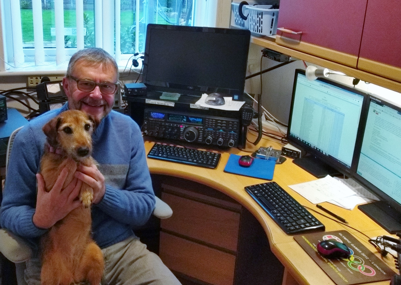
In the shack today with Treacle:

On the hill - on the way to White Coomb GM/SS-030 last week:


Fixed & Portable Stations:

Portable:
My Activator station equipment remained the same as it did in 2017:
HF Rigs - Yaesu FT-857 - Elecraft KX2 - YouKIts HB1B with 20/30/40m link dipole on 5m pole
VHF Rigs - Yaesu FT1500M (50 watts) - VX-170 (5 watts) - FT270 (5 watts) with vertical end fed dipole on 5m pole or RH770 handheld whip on the handhelds.

Fixed:
My Chaser station equipment was upgraded considerably in 2018 as a result of getting back on the air from a new QTH on 1st Jan 2017.

Aerials:
The most important part of the station after being there…

It took 15 months and an appeal to the England & Wales Government Planning Inspectorate to secure permission to erect a 12m high Tennamast in my back garden to support a Hexbeam and a 4m/6m dual band yagi. These aerials were in place by June 2018. The coaxial feeds are all Ecoflex 15 buried in the ground in BT ducting where possible. I continued to use an 80m band OCF dipole I erected in a tree in 2017, however I improved the feed arrangements for that, and raised it in the tree I have to a greater height. In September I fixed a pole to the opposite side of the same tree and fed that from the tree base as an inverted L - total length 130 feet at an average height of 45 feet. I now have approximately 2000 feet around and in my garden to tune the inverted L against. This aerial I use on the 160m and 60m bands. On 144 MHz I continued using a Wimo 2m 7+7 cross yagi fixed to the house. The two rotators I have are Yaesu G-1000DXC and G-450C.

All base station radio’s used for chasing were purchased secondhand in the last 5 years:

HF Rigs: Yaesu FTDX5000 (2010 model), Icom 7300 (2016 model), Icom 7400 (2009 model), Yaesu FT-1802 (Age not known).

The FTDX5000 is in daily use on HF up to 50 MHz, the IC7300 is my HF backup and also provides the 70 MHz band, the IC7400 has just been used this year on 2m CW/SSB. The only transceiver purchased this year came from a ham in Northern Ireland - this is the IC7300 which I collected at the Blackpool Rally in April. I had one major repair to pay for in 2018 - this was replacement of the two MRF150 PA devices in the FTDX5000 which went POP in the autumn for no apparent reason when I was running with 120 watts on FT8 on the 12m band. Yaesu UK did the repair which took just two weeks. Good job.
So how did I do with all this equipment in my armoury? Well with more I time on my hands having fully retired at the end of March from my work as a Magistrate I spent more time in the shack, and ended the year 8 pounds heavier than when I started the year! Yes, sat on my backside in the shack does no good for keeping ones weight down… Unfortunately family members bought me chocolate, licourice and toffee for Xmas and I am slowly getting through that afterwhich I will make an effort to cut down on eating rubbish. Activating helped I’m sure to keep some weight from going on, so I hate to think what my weight would have been with without it! I was 66 in November, and the older age and extra weight means I have noticed that I am now slower climbing to the summits than I was when I stated SOTA activating in 2005.

Stats:

My combined QSO total in 2018 was 6090 contacts with 136 DXCC Countries.
Out of the 6090 contacts 3189 were CW, 2311 Phone and 590 were DATA. I started using FT8 in March, to supplement my RTTY and PSK31 operating. Hence the higher than usual DATA QSO total this year. Just a handful of these FT8 contacts were SOTA Chaser QSOs however.
Total fixed station QSOs (Mainly Chaser contacts) were 4184.
Total Activator QSOs made operating from 9 countries in two continents were 1906.
As an all round SOTA operator I increased my SOTA Complete total to 741 by adding 143 SOTA Completes. This was helped by activations in VK2 (With VK2IO), OK (with GI4ONL and OK2PDT), and a holiday tour to Friedrichshafen with my XYL taking in activations in FL, DM, ON and OE (with OE9HRV). I further added a few activation days in GW (Solo and with M0PYG) and in GM (Solo and with M0PYG).
I made 17401 Chaser points in the year and was top All G scorer.
I made 756 Activator point in 2018 and was top G scorer, but was beaten by GI4ONL in the All G activator category.

Looking forward to 2019 I have several Tours already booked, and I must get back to Hensbarrow Beacon later this month when I am in South Wales to Re-Complete England.The fell top assessors (The Meddlers) moved the summit reference from the trig point to the top of the slag heap some time ago and I haven’t yet got back there. I believe no one else has Completed England, so I must go back and retain my mantle!

Plans for 2019 are already made with overseas tours planned for March, May and IN July to coincicide with the Tour de France in the FL/VO region. Thee may be something for September, we will see how the year passes and decide later.

Health:

Reasonable with a few issues - I have a minor cardiac issue - an irregular heartbeat which surfaced a few months ago after I submitted myself to a general anaesthetic to check for Prostate Cancer, of which I am clear. However, during the tests it was discovered that I have this irregular heartbeat, so the GP has put me on a tablet for it to thin my blood as the GP says I am more likely to succumb to a stroke because of it. We carry on in SOTA activating for a few years more… I cannot see me ever giving up SOTA Chasing which I really enjoy also. As a walker anyway I continue being a part of Ryedale Walking Group of which I am the 2019 Membership Secretary. I organise at least one holiday every year for the walking group which usually includes SOTA activating as part of it.

The SOTA MT get my heartfelt thanks for all they provide by way of the SOTA infrastructure, reflector, database, website, awards and the SMP (So useful - thanks Rob DM1CM, also Andy MM0FMF for providing the much improved SOTA Cluster and to the many activators who share their information to help others via blogs, the reflector, personal messages and in the tracks page of the SMP.