Tuesday, 9 July 2013

Wainwright's Pennine Journey - Appleby to Sedbergh

Day 17 Saturday (PM) 06 July 2013 Appleby to Sandford
(5.75 miles 560 ft ascent)

Here we are at last - resuming our amble at our own pace on Wainwright's Pennine Journey....over two years since we first started the 247 mile walk! 

Geoff, Judy, Phil, Chas, Yvonne and Jennie resume the Pennine Journey from Appleby 
Once again we parked two vehicles at Appleby Railway Station for several days, leaving there at 1.30pm for a short walk to the Sandford Arms, a country inn in the village of the same name just off the A66 where we would spend our first night. The other hostelries which we had pre-booked were at The Nateby Inn and The Moorcock Inn at Garsdale, from where we would walk the following day into Sedbergh (at least some of us would - more on that later!).  We had also left one car at Sedbergh, where Yvonne and Chas have a caravan, and one car at The Moorcock Inn, Garsdale. Vehicles which were strategically placed to assist us at the end of this four day section.

We followed the valley along the River Eden for the next two days right up to the watershed in Mallerstang when we met the River Ure. Unlike on the last section of the PJ (as we have become to know it) I was not monitoring the conditions of the route or the waymarking, which on this section was looking complete. The work had already been covered by another volunteer. This fingerpost at Great Ormeside displays the attractive Pennine Journey Waymarker:


Chas, Yvonne and Geoff at Great Ormeside
As we neared Sandford late afternoon we were confronted by an unusual blockage of the public right of way. A barrier using a JCB and its buckets had been placed across the bridleway. This was temporary and was being used as a means to keep cattle in a specific part of the yard! We managed to negotiate it without problem. 

Route blockage at Blacksyke near Sandford 
At Sandford bridge we left the route to head up to the village to the pub where we stayed the night. We had enjoyed lovely hot weather on our walk from Appleby and it was set to continue for the rest of the week.  

Day 18 Sunday 07 July Sandford to Nateby
(13.5 miles 1250 ft ascent)

We left the Sandford Arms after breakfast at 9.45am
Our route continued to follow the River Eden through to top of the Mallerstang Valley. As we headed towards Brough where we were hoping to buy our lunch, we could see Nine Standards Rigg and Wild Boar Fell to our right. This was another hot day and we took our time on the paths, tracks and byways, skirting the village of Warcop and passing through Little Musgrave on our way to Brough.


Musgrave Church
The Mole Catcher had visited Hall Garth Farm at Great Musgrave
Brough Castle came into view and we were pleased to see it had its own tearoom - Brough Castle Farm, something we were not aware off. This saved us having to deviate from our Pennine Journey route - we thought we may have needed to cross the A66 to find a cafe.

Tea, sandwiches and a choice of ice creams set us on our way to Kirkby Stephen
The lady in the cafe thought it odd when we said it was a six mile walk to Kirkby. She said it was only 4 miles but failed to grasp that we were taking the scenic route via the villages of Kaber and Winton to Frank's Bridge in Kirkby Stephen.

Cricket  match in progress at Kirkby Stephen
The route then led us across the town cricket pitch (there was a match taking place) and then on to Nateby on a well maintained bridleway. The bridleway forms part of a poetry path here. Twelve short poems were written by the local poet Meg Peacocke and these have been carved on to blocks of stone by artist Pip Hall. You can find more details here.
One of the twelve sculpted stones on the Poetry Path near Nateby
My navigation went a little off south of Hartley Castle and we somehow found ourselves in a small wood having left the bridleway. We wasted around 10 minutes, but by retracing our footsteps we found we had gone wrong by not climbing a ladder stile. After crossing the former railway line we reached Nateby for a refreshing drink served by Hannah who warmly welcomed us to tThe Nateby Inn. She was in charge as the landlady who is called Gaynor, was away for the day with her family at Alton Towers. We met her the following morning when she served us breakfast, when she recalled a recent visit by David Pitt the Author of the guide book, so she knew all about Wainwright's Pennine Journey. 

At the Nateby Inn at 4.30pm after walking 14 miles
We enjoyed staying at The Nateby Inn, the food was good. A tearoom for walkers and cyclists has been created at the rear of the pub and this doubles as the breakfast room. The bedrooms were quite small but adequate for a one or two night stay. The pub was formerly known as The Black Bull but Gaynor told us that changing the name gave the pub more of an identity. 

Day 19 Monday 08 July Nateby to Garsdale Head
(11.2 miles 1500 ft ascent)

Having driven down the Mallerstang valley many times on the B6259 since I took moved to Yorkshire in 1993 I was really looking forward to actually walking through it on our way to The Moorcock Inn at Garsdale Head. For Jennie and me the boots we were wearing were named after where we were walking - Altberg Mallerstangs!

Enjoyable it was to walk, in the company of my wife Judy and friends, on a lovely hot summer's day. But not everyone in the group found it so comfortable as we made our way up the valley....

Just as we were about to leave the Inn the voice of our friend Nick Langmead (Callsign G4OOE) came crackling through on our VHF radio (Geoff and I are radio hams). We both called Nick and made contact - he was on Cross Fell and was later heading for Nine Standards Rigg. 

Wild Boar Fell peeps out over the hill in the middle of the picture
The route

From The Nateby Inn we followed a bridleway through to Croop House on the west side of the Eden. From here we used a BOAT (Byway Open to All Traffic) which took us to a C Class road near the remains of Pendragon Castle. Cumbria County Council maintain this byway and on the day of our visit were busy installing a new cattle grid where the byway joins the tarmac road at grid ref NY 779030:

A work in progress near Pendragon Castle
Continuing on we reached The Thrang, crossing over the B6259 to join another BOAT which is in fact the old road which we followed for 5.5 miles across the side of the fells. This is known as The High Way and it also forms part of the long distance walk called Lady Anne's Way. 
Wild Boar Fell and the Settle - Carlisle railway line below it - seen from the High Way
We'd read about the Eden Benchmarks. These are a series of sculptures marking out the path of the Eden. We knew there was one such sculpture on the High Way called The Water Cut and decided that this would make a good target to aim for to have our lunch. We arrived there at 1.00pm for a half hour stop.
At The Water Cut - part of the Eden Benchmark Project
Continuing on we reached the derelict farm buildings at High Dyke just after 2.30pm. From here we descended to Blades and having crossed the watershed leaving the Eden behind, encountered the River Ure. From here it was a short walk to the Moorcock Inn where we stayed overnight.
The Moorcock Inn at Garsdale Head
The pub was very comfortable with large settee's. Food wise large portions were the order of the day, and the rooms were very fairly priced. Jennie and I chose from the Tapas menu and we ordered far too much, whilst Geoff stuck to one of his favourites, Steak and Ale Pie. 

Day 20 Tuesday 09 July Garsdale Head to Sedbergh
(14 miles 1750 ft ascent)

This was our last day and it was hotter than ever as we left the Moorcock at 9.45am. After crossing the railway we crossed South Lunds Pasture. Due to the heat most of us were wearing shorts and we managed to negotiate the nettle beds we were warned about in David Pitt's guidebook without too much difficulty. What followed was a most remote section of the walk - a five mile stretch of moorland before we reached Uldale House.


The remote Holmes Moss - the Howgill Fells in front
We followed broken drystone walls, old tracks and moorland for over two hours to reach Whin Stone Bridge where we stopped for lunch in the shade. The River Rawthey had been forming itself to our left gathering waters from Baugh Fell on our left and Swarth Fell on our right. At Whin Stone Bridge where we stopped, there is a waterfall.  


Lunchtime in the shade at Whin Stone bridge
Continuing on we reached the A683 Sedbergh to Kirkby Stephen road. The heat of the day was really getting to us now and the climb up to Murthwaite was a grueller. Jennie was starting to feel quite ill at this point but she soldiered on via what is an excellent bridleway to reach the Cross Keys Temperance Pub at ten to three. On account of how she felt it was wise for her to leave the walk at this point, so Jennie, Yvonne and Chas opted to catch the next service bus back to Sedbergh and to walk that final section on another day. 

We all had plenty to drink at the Cross Keys at Cautley, some of us enjoying a few glasses of 'Owd Oldham's Sarsaparilla, produced by the Mawson family of Oldham. Geoff (who hails from Oldham) recalled visiting the shop in his youth where this drink was made and sold. The drink comes as a cordial, and here is Geoff negotiating the purchase of a bottle from the proprietor of The Cross Keys:


The three of us then set off to cover the four miles or so back to Sedbergh on the path and track above the River Rawthey. We met up with the others at their caravan just after 5.00pm. Jennie was feeling much better and was able to drive herself back home to York. She returned in August to The Cross Keys at Cautley to thank the staff for their hospitality on the day we passed through, and whilst there, walked the section of the Pennine Journey into Sedbergh which she had omitted.  

We intend completing the walk from Sedbergh to Settle sometime in September.

Thursday, 27 June 2013

G4OBK SOTA Freeholds Top G/SP-011 May 2013

After visiting my mother in Leyland on my way back to North Yorkshire, I made for the M65 leaving it at junction 5. I then passed through Rawtenstall on my way to the parking spot for Freehold's Top SP-011 which lies between Bacup and Todmorden in the A681. 

I drove up the rough track a short distance and parked by a gate at grid ref SD 8913 2384. There was just room for one car there. It felt secure as the car could not be clearly seen by passing traffic. I set off with my Border Lakeland Terrier Treacle on a lead at 3.45pm. She loves doing SOTA, there are always plenty of interesting smells on a moor like this one.....

Distance walked - 3.5 miles with 280 feet ascent
From the gate I used the little walked Rossendale Way which proved to be quite boggy. If you take this route make sure you keep to the left of the fences and walls along the way to the summit. The walk up took me 33 minutes with minimal ascent. 


I set my antenna up near the trig point and pond. Take off was reasonable and I worked 9 stations with a Yaesu VX-170 and vertical dipole. I worked G4ZRP on The Wirral, but only just, as Hailstorm Hill SP-009 was right in the line of sight:


If practicable I prefer to take a different route back and as my walk up was over boggy land I went back down via the Liners Gate track (a route since favoured by Tom and Jimmy M1EYP/M0HGY). This proved be a good move, although I had to climb back up a spoil heap to reach my car at the gate. The walk back took me 29 minutes. On the way I passed some former coal mines and a radio mast - use not known:

Not my antenna!!
All in all a pleasant activation which was accomplished in under 90 minutes all round. 

G4OBK SOTA Billinge Hill G/SP-017 May 2013

I wanted to visit my mother in Leyland in May so I opted for an early start to activate Billinge Hill near Wigan. This summit at a mere 179m ASL is the lowest Marilyn in the South Pennines and one of the easiest to climb.

I didn't take any photos but the summit and its environs were much better than I had been led to believe from older reports. I felt the lane in which I parked my car, Beacon Road (SD 528010), was secure being in front of some houses. I parked near the top of the road. I followed the same path as taken by G0EWN in his report of October 2012. The summit of Billinge Hill was reached in just 12 minutes. The footpath was well defined and partly tarmac. At one point I overshot as you can see from the map. This was near a compound containing a generator which was being powered from the methane being bled off the former landfill site. I think the council should be proud of what has been achieved here - Billinge Hill now sits above a pleasant country park.  


Take off was pretty good on 2m FM with just 5 watts and a vertical dipole - perfect for working the locals at an early hour. I was on the air for around 15 minutes before the callers dried up:


I drove on after this activation to my mother's QTH in Leyland with my thoughts ahead of an activation of Freehold's Top, near Todmorden on my return to Yorkshire later in the day.

Wednesday, 26 June 2013

Good Tropospheric Propagation in 50 MHz Contest 25th June 2013

Inter UK Radio propagation conditions were excellent in last night's Radio Society of Great Britain 50 MHz Activity Contest.


VHF Antennae at G4OBK - a 50/70 MHz hybrid yagi was the contest antenna used
As part of the Travelling Wave Contest Group I operated from 8:00pm until 10:30pm, completing 114 contacts with UK amateur radio stations in 20 locator squares. 

My best DX (Long Distance) contact was with G8BCG. a 6 Metre band specialist,  who lives in Liskeard, Cornwall. 

Here is map of where all the contacts I made were located:

Best DX Peter G8BCG Liskeard Cornwall - 493 Kms from Pickering North Yorkshire

Tuesday, 11 June 2013

SOTA Cycling Weekend - June 2013 - SB-005 Sighty Crag

Sunday 9th June 2013 (am)


It was the first ever SOTA International Cycling Weekend and I made a late decision to take part in the action by spending two further days in Northumberland around the Scottish border bagging and activating my last four Marilyn summits in the region.  The previous day I made an on-line booking to stay in the YHA Bunkhouse in Bellingham. This was the day after I returned from the same area when I climbed The Cheviot and Housedon Hill with my friend Nick G4OOE, who thankfully did the driving on what was a long day. 

I left home at 5.45am and within ten minutes I hit a problem on the A170. A road traffic accident had occurred just after 5.00am in the village of Wrelton and this is the scene which presented itself:


I later discovered that a Ford Fiesta had crashed and rolled over. 5.00am was a funny time for that to happen, and I wondered if it was anything to do with the Modified Car Show which was due to take place later that day in Pickering.... A diversion was in operation but it was only a short detour and I was soon on my way up to the east side of Cumbria travelling via Alston and the North Pennine road which passes NP-003 Burnhope Seat.

I reached my parking place at 9.00am, marked on the OS map as The Loan, grid reference NY 5616 7853.  

My bike - next day on Tosson Hill G/SB-007
My bike was inside the car. Although I ride a lighter bike than this one locally on an almost daily basis I hadn't ridden this machine for around two years, so the previous day I serviced it by way of cleaning it down, pumping the tyres up to 70 psi, cleaning and lubricating the chain and gears and adjusting the brakes.  I also removed the front mudguard on account of the rough tracks to be encountered on my SOTA tour and to help ease loading the bike into my car. The recent weather had been dry and it was expected to remain so. 

The first obstacle was a locked gate into the southern corner of Kershope Forest, so the bike was lifted over the gate and off I went, travelling two miles before a steep hill became too much so I dismounted for a short section before continuing to ride. I realised that I could not ride to the summit of Sighty Crag, or even push my bike up to it. I left my bike in a small quarry at 5872 8056 after 3.4 miles and didn't feel the need to lock it in this remote location.  From there I set off on foot to head towards The Hewn Block - some crags on the tussocky moorland to the east of my bike park. At 5917 8056 I hit a barbed wire fence and handrailed along it in the hope of finding a gate or stile.

My view from the barbed fence on my way to Sighty Crag - and before the mist rolled in
There was none, so at 5925 8028 I scaled the fence to eventually reach another fence (non-barbed) which ran along the line of the summit. it was slow going over the tussocks but I reached my goal at 1035 am. 

The most remote and least visited of all England's Marilyn Summits - Sighty Crag
I can understand why G/SB-005 is the least visited of England's Marilyn's (and probably the least activated for English SOTA). This is due to its sheer remoteness, the long walk/ride in regardless of which route is taken and the summits lack of redeeming features when you get there, especially when the mist is down as it was on my arrival!

A friend of mine sent me this poem about Sighty Crag - writer unknown but whoever it was, the poem gives a good appreciation of why this place is the least visited Marilyn summit in England:

We guys who hills in Blighty bag
Might shy away from Sighty Crag.
It surely is a mighty drag
Enough to make the sprightly flag
When faced with forest, mire and hag
Shrouded in a whity clag.
But conquer and you'll rightly brag
'I found the top of Sighty Crag!'
Descending is a further fag
And goes to show we're slightly mad.

The website www.hillbagging.co.uk shows today that 977 registered users have climbed Helvellyn - the most visited Marilyn in England. Sighty Crag is the least visited - only 61 registered users have been there. It was 60 before I called in. Next least visited is Peel Fell with a score of 72....I went there after Sighty Crag. Housedon Hill is 3rd from the bottom with a score of 73....I was there with Nick G4OOE two days before Sighty Crag. It's great to go to places that the herd don't visit, it gives me a good feeling, a feeling that the explorers of old must have also felt. That's wanderlust for you! 

My route showing where I parked the bike on my way to Sighty Crag
My QRP SOTA station was set up for HF CW and VHF 2m FM using homemade dipoles - a vertical for 2m and a link dipole for 40m, 30m and 20m. Conditions were good and 32 stations were worked for SOTA, 25 on HF and 7 on VHF. This was the first time that the 20m and 30m bands had been used out of the 17 previous activations of the summit. The last activation being in August 2011 when Paul G4MD/P visited.

Activity complete I chose to head across the moor to an unmarked cairn at 5978 8071:

I was back at the quarry to collect my bike at 1255 pm and chose the steeper route back to The Loan where my car was left. This was a white knuckle ride, exhilarating to the limit  as I reached a speed on 28.5 mph on the downhill, only to receive a puncture on sharp stones near the bottom, however there was just enough air in my rear tyre and enough speed to take me to the forest gate! 

Deflated back tyre!
I loaded the car and had my lunch before driving to my afternoon summit of Peel Fell G/SB-004, on the Scottish Border. I decided to walk in to this one and repair the bike at the end of the day.  I put Newcastleton into my Tom Tom and that set me on my way around Kershope Forest via a gated road and then from Newcastleton I went on towards the top end of Kielder. (See next blog for Peel Fell G/SB-004). 

Stats:
Bike: Ideal Traveller Hybrid
Distance cycled: 5.9 miles
Distance walked: 2.5 miles
Total ascent: 1800 feet
Time taken out and back: 3 hours 55 minutes
Radio's used: YouKits HB1B 5 watt CW Transceiver and Yaesu VX-170 5 watt FM Transceiver both internal batteries
Antennae: Homemade 3 band link dipole, homemade 2m vertical dipole 
Amateur Bands used: 40m CW, 30m CW, 20m CW, 2m FM
Contacts made: 32

SOTA Cycling Weekend June 2013 - G/SB-004 Peel Fell

Sunday 9th June 2013 (PM)
After puncturing returning from Sighty Crag back to my car I decided to walk to the summit Peel Fell from the parking spot near Deadwater (NY 6086 9643). My intention was to replace my bike inner tube that evening when I reached my accommodation in Bellingham. 
Walking route to Peel Fell G/SB-004
The rarely activated summit of Peel Fell lies on the Scottish Border.  More details provided by Jim G0CQK can be found here (Thanks Jim). The walk to the summit took 1 hour 36 minutes and was straightforward - despite this I took a wrong turning on a forest track which wasted around 12 minutes. I had to fight my way through fallen trees to get back onto the right track. My GPS track is in fact inaccurate. I think the device was receiving skewed signals owing to the tree cover adjacent to the track. This is why the map appears to show that I used a different route through the wood on my return. 
Peel Fell G/SB-004 looks a long way off on the track at Deadwater
Once Rushy Knowe is reached at 6144 9900 you are in Scotland. A broken wall and the remains of a fence can then be followed up to the summit. The walk becomes steeper and much more strenuous before the summit of Peel Fell (602m) is reached. This height means Peel Fell meets the 600m UK limit and can be classed as a mountain.  My path was blocked in one place by a fallen tree and the forestry fence had to be climbed to get around the obstruction:
Route blocked
I reached the summit at 4.00pm, weather was cloudy but mild as I set up my station. 
G4OBK/P on Peel Fell G/SB-004
HF band conditions were very poor. I completed only nine contacts with the following stations in 25 minutes before packing up:

2m FM M6EPW/P Flat Fell (Western Lake District)
40m CW G0NUP (England)
40m CW G4SSH (England)
40m CW G4OOE (England)
40m CW PA9CW (Netherlands)
40m CW PA0SKP (Netherlands)
40m CW MW0IDX (Wales)
30m CW CT1BQH (Portugal) (1st time 30m activation of Peel Fell)
2m FM M0RCP/P Summit to Summit - Calf Top, North Pennines

There were no contacts on the 20m band despite me making repeated CQ calls, so I gave up. 

The nearby Deadwater Fell Communications Station (571m ASL) as seen from Peel Fell 
View leaving Peel Fell on the English / Scottish Border
The walk back down to my car took me 64 minutes and at 6.30pm I was on my way to the YHA Bunkhouse at Demesne Farm, Bellingham. This took me through Kielder Forest and past the reservoir. When I arrived I changed the inner tube in my rear tyre so the bike was ready for the two remaining summits on Monday - Tosson Hill G/SB-007 and Long Crag G/SB-008. 
Success - puncture repaired and bike ready for Tosson Hill and Long Crag tomorrow
Job done I settled in at the bunkhouse, took a shower and then made my way to the nearby Cheviot Hotel in the village for a good meal and several drinks. 

Stats:

Bike: Out of action due to puncture
Distance walked: 7.16 miles
Total ascent: 1550 feet
Time taken out and back: 4 hours 5 minutes
Radio's used: YouKits HB1B 5 watt CW Transceiver and Yaesu VX-170 5 watt FM Transceiver both internal batteries
Antennae: Homemade 3 band link dipole, homemade 2m vertical dipole 
Amateur Bands used: 40m CW, 30m CW, 2m FM
Contacts made: 9

SOTA Cycling Weekend June 2013 - G/SB-007 Tosson Hill

Monday 10th June (AM)

With two summits remaining to bag and activate I rose early, leaving the Bunkbarn in Bellingham at 7.30am for my drive to the Simonside Hills, around 20 miles away. The YHA bunkbarn I stayed at Demesne Farm  was excellent value for a single traveller -  clean, modern and very well equipped, a fine example of farm diversification if there ever was one.

Demesne Farm YHA Camping Barn Bellingham
The bunkhouse sleeps up to 15 people at a cost of £17 per night. All you need is a towel and toiletries. I booked online the previous day via the YHA website. As it was a Sunday night I had the whole bunkhouse to myself - ensuring a good sleep. 

So on to the parking for Tosson Hill. I started from the forestry car park (free) at NZ 037996, five miles by road from Rothbury.  The forestry track was excellent for my bike up to NZ 0178 9905 and after a short push up a rough steep section I was back on the bike and able to ride to the summit.

My ride to the summit of Tosson Hill G/SB-007
After snapping my short 4m fishing pole the previous day I had to bodge a repair with insulation tape but managed to get the antenna up at  a mere 10 feet. Amazingly, even with QRP I still made plenty of contacts and activated the 30m band for the first time from this summit. I finished with 20 contacts on HF and just one on 2m FM!

G4OBK/P on Tosson Hill G/SB-007 International SOTA Cycling Weekend June 2013
The ride up took me 50 minutes, and the ride down just 26 minutes, over a return distance of 6.4 miles. I left the car park at 11.30am to head four miles north of Rothbury for my final Scottish Border summit on the English side, Long Crag SB-008.

Stats:
Bike: Ideal Traveller Hybrid
Distance cycled: 6.4 miles
Total ascent: 1050 feet
Time taken out and back: 3 hours 0 minutes
Radio's used: YouKits HB1B 5 watt CW Transceiver and Yaesu VX-170 5 watt FM Transceiver both internal batteries
Antennae: Homemade 3 band link dipole, homemade 2m vertical dipole 
Amateur Bands used: 40m CW, 30m CW, 20m CW, 2m FM
Contacts made: 31
Countries worked: G, ON, GW, EA, HB9, OK, OM, DL, HA, F, SP.  

SOTA Cycling Weekend June 2013 - G/SB-008 Long Crag

Monday 10th June 2013 (pm)

Trig point nameplate on G/SB-008 Long Crag near Rothbury, Northumberland
The parking spot for Long Crag is about 300m off the A697 north of Rothbury at grid ref NU 0918 0723. The gradual ascent to the summit is ideally suited to the bike, especially in such dry conditions - a good well surfaced track and on the moor there had been no rain to speak of for some time, so it was bog free. This route would also make an easy pleasant walk and was without doubt the easiest of the four summits ascended on my two day tour.


Route from Rough Castles to the summit of Long Crag G/SB-008
From my car to the summit on the bike took a mere 27 minutes. My return took 10 minutes, such was the graded quality of the track - less potholes to look for than on the metalled roads in my home town!
Summit of Long Crag G/SB-008
With my broken fishing pole I set up my station around 250m back along the path at around 5m down from the actual top - I was able to use a Waymarker post on which to support my pole. 
Operating position on G/SB-008 Long Crag
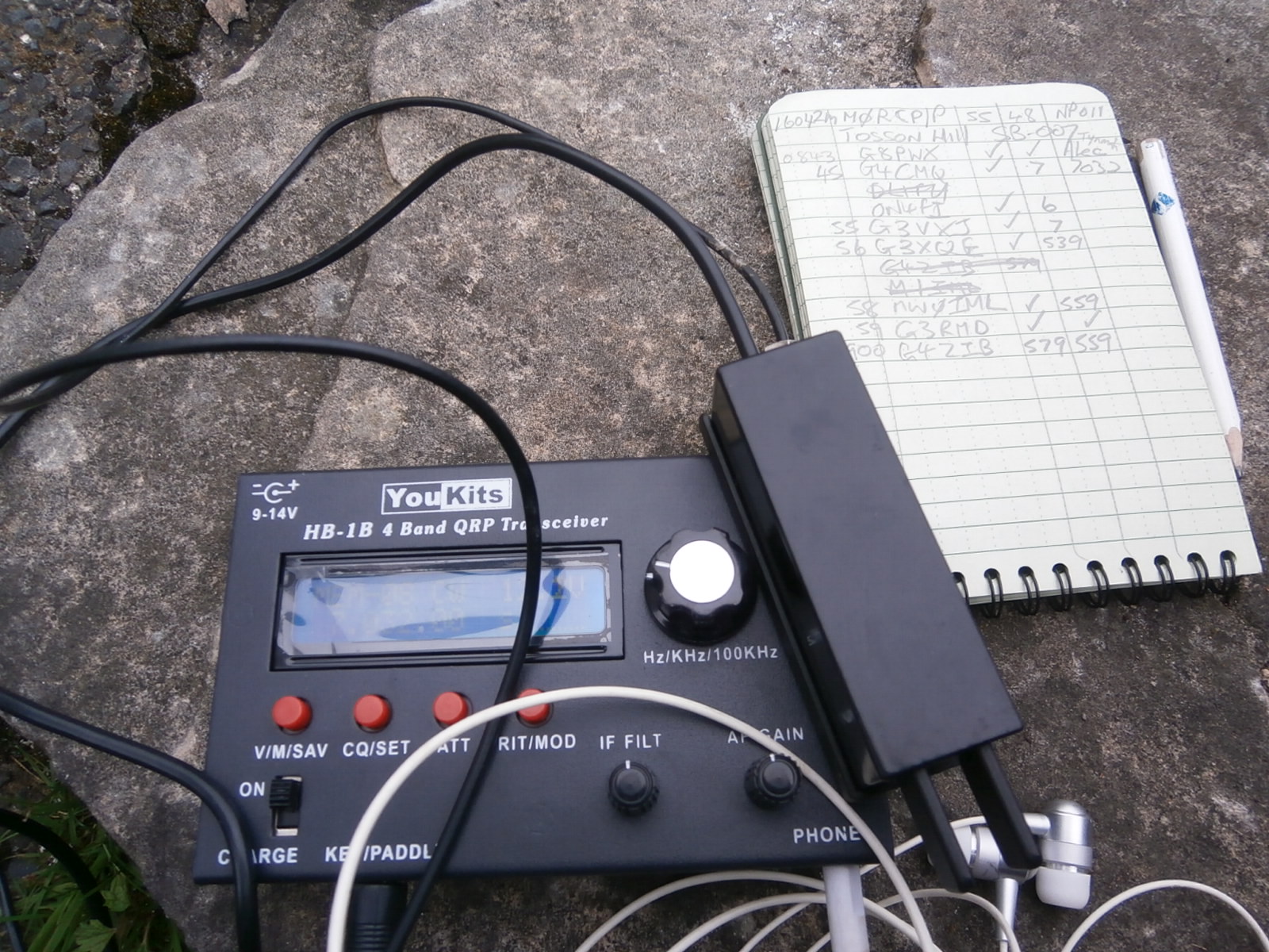
With the centre of my inverted vee again at only 10 feet and with the ends of my dipole 3 feet off the ground I was able to make 20 contacts on 40m, 30m and 20m (CW of course!).  Conditions were similar to what I experienced on Tosson Hill SB-007 earlier in the day.  In addition I made just two contacts on 2m FM with George G2ARY and Lesa M0BQD in New York (Near Newcastle!). Best DX was with YO2LIW on 20m with 4 watts and low dipole.  The YouKits HB1B (Purchased recently from SOTABeams) was proving to be a useful tool to have in the rucksack for SOTA - complete with batteries it weighs just 520 grams and is a delight to operate.  

SOTA HF Station: HB1B Transceiver -  Palm Key - earphones - Write in the rain notebook and pencil
After 40 minutes of operation the callers dried up so I closed the station down, satisfied that I had now completed the Scottish Borders SOTA area, to add to my completions of the Lake District and Northern Pennine area. My next target is to finish activating the South Pennines Area later in the summer and make more inroads into the Welsh Border area Marilyn Summits. 

Notable points about this two day Scottish Borders tour:
  • Miro OK1DVM was the most worked station with 5 contacts. 
  • I never saw a single person along the tracks or on the summits on all four activations, even though the weather was good.  
  • The YHA Bunkbarn concept is a good one. It enables you to have the freedom you want with no time schedules other than your own. Perfect for a one person short tour and very cheap at £17 per night. 
  • QRP CW on HF is effective providing at least 3 bands are covered. This way if conditions are bad you will always make sufficient contacts to qualify the summit - on Peel Fell, the highest summit, I only scraped 7 contacts over the three bands.
  • I'm glad I was carrying a spare inner tube!
  • I can understand the reluctance of SOTAists in staying away from Sighty Crag (activated 17 times, the last time in 2011). The summit is so hard to get to and has no redeeming features, I recall the tune "1000 miles from nowhere" by Paul Hardcastle, and it felt like it was! 
Stats:
Bike: Ideal Traveller Hybrid
Distance cycled: 4.25 miles
Total ascent: 450 feet
Time taken out and back: 2 hours 2 minutes
Radio's used: YouKits HB1B 5 watt CW Transceiver and Yaesu VX-170 5 watt FM Transceiver both internal batteries
Antennae: Homemade 3 band link dipole, homemade 2m vertical dipole 
Amateur Bands used: 40m CW, 30m CW, 20m CW, 2m FM
Contacts made: 22
Countries worked: G, ON, PA, HB9, OE, OK, DL, OM, YO.

Friday, 7 June 2013

G4OBK & G4OOE team up to visit The Cheviot G/SB-001

Friday 7th June 2013 AM - The Cheviot G/SB-001

After visiting all the Marilyn Summits in Cumbria and the North Pennines and activating them for Summits On The Air (SOTA) it was time to turn my attention back to the Scottish Borders where there are 8 summits.  I had only visited two previously, Ros Hill in 2005 and Shillhope Law in February 2013 both with my XYL Judy.  I decided that with a free weekend and after a dry period, that I would dedicate a long weekend to the English side of the Scottish Border. My friend Nick G4OOE was very interested in activating the border summits and offered to do the driving. I purposely chose these two summits, as with the SOTA International Cycling Weekend starting the next day my plan was to return with my bike and activate the last four summits over two days using my bike as the method of transport. See next blog. I was also accompanied on this trip by my Border Lakeland Terrier Treacle, back in her homeland!

Plenty of parking at Langleeford and a perfect day for fellwalking

We left Pickering at 5.30am arriving at Langleeford (NT 954225) in the Harthope Valley three hours later.  The public road down the valley is quite rough and potholed and is very steep in places. This map shows the walking route via Scald Hill that we took on the day:

GPS Track from Langleeford  to The Cheviot - the return route via the Harthope Valley is not recommended
The walk to the summit trig point over a distance of 3.3 miles took 1 hour and 40 minutes. I was quite pleased with that and with the weather having been so dry for two weeks we had no problem crossing several dried up bogs. Once the ladder style was reached and crossed at NT 9142 2068 we were on the plateau at 805m with the summit only 10m higher than this. The path was then flagged to the trig point and beyond. 

The path on the plateau of The Cheviot is now flagged


We were soon on the air taking turns on VHF (5 watts) and HF CW (50 watts). Conditions weren't at their best and I failed to make any voice contacts on HF. Morse was much more productive. 


For the first time on Cheviot the 30m band was activated, by G4OOE, and for the first time 20m was activated by G4OBK.

We completed summit to summit contacts with HB9BCB/P in Switzerland and with S52CU/P in Slovenia. This is me operating pictured right - the SOTA flag was flying.   Visibility was poor, the sun did not reappear until we were back down in the valley. 

A few walkers starting appearing and we had to field the usual questions - once again Joe Public confused ham radio with CB which seems to be better known.  We posed for a photograph at the trig point before heading towards the Pennine Way main route at Scotsman's Cairn. The leg to The Cheviot from the Pennine Way is a spur and not all Pennine Way walkers visit the summit.

Treacle Phil (G4OBK) and Nick (G4OOE) on The Cheviot

Once we reached Scotsman Cairn it was time to take our jackets off as the sun came out.


The writer at Scotman's Cairn on Cairn Hill NT 903195

The route to the cairn and then down the hill to Scotsman's Knowe was fine, however from that point on right through to the sheep pens at Langleeford Hope the route was difficult. This involved crossing the burn around 20 times over 2.5 miles. I wouldn't go that way again. It would have been better to stay high and walk over Comb Fell and Hedghope Hill. That route would have brought us straight back down to the car park. 


Nick on the awkward path that repeatedly crosses the Harthope Burn

We arrived back at the car park just before 3.00pm for refreshments before going heading to our next summit Housedon Hill G/SB-010, north of Wooler. 

Stats:

Operators Phil G4OBK & Nick G4OOE

Distance walked: 8.5 miles
Total ascent: 2575 feet
Time taken out and back: 5 hours 15 minutes
Time spent on air: 59 minutes
Radio's used:
Yaesu FT-857 HF Transceiver 50 watts from 5Ah LiPO battery 
Yaesu VX-170 5 watt FM Transceiver internal batteries
Antennae: Homemade 3 band link dipole, 2m vertical dipole 
Amateur Bands used: 40m CW, 30m CW, 20m CW, 2m FM
Contacts made: 43

Phil G4OBK & Nick G4OOE team up to visit Housedon Hill G/SB-010


On the afternoon of 7th June 2013 Nick (G4OOE) and I left the car park for the Cheviot in the Harthope Valley at 3.15pm and headed north of Wooler to activate the lowest of the Scottish Borders Marilyn Summits Housedon Hill, a mere 266m high. 

The most convenient place to park is close to the end of the C Class public road at Reedsford, (NT 8930 3254). The spacious and signposted parking area is on the right adjacent to some cottages. No one challenged us parking there, as we set out for the summit just after 4.00pm. 
My terrier Treacle (after climbing The Cheviot earlier) needed a rest so she was left sleeping in Nick's car as we climbed to the summit. 

Gorse on the flank of Housedon Hill G/SB-010

We had decided to operate QRP (low power) on this summit so were carrying a lighter load than earlier in the day on The Cheviot. A 35 minute climb took us to the summit, the best and driest route being via a narrow gate in the fence corner at NT 8983 3289, a point where cattle do not seem to gather as they do at the previous gate. 

Views from the summit of Housedon Hill:


The grass topped summit was surrounded by much higher hills some distance away and offered a superb viewpoint, whilst being disappointing from a VHF FM low power point of view - in that working condition our CQ calls went unanswered, so we reverted to HF CW and got out our Morse Keys, both of us setting up our link dipoles end to end using the fence which runs adjacent to the summit, to support our fishing poles. 

Nick in action on CW on the 30m band
Nick was using his Yaesu FT-817 with internal battery whilst I was using for the first time on a summit, my YouKits HB1B 4 band QRP CW Transceiver.

The simple and basic HB-1B 4 band CW Transceiver
With fine weather and no shortage of stations calling we had quite a lengthy activation making 37 contacts between us with 10 European countries.  The best DX (long distance) contact being with UU4JDD in Ukraine on the 10 MHz (30m) band. We left the summit just after 6.00pm, and it took 27 minutes to walk back down to the car park. 

Descending from Housedon Hill on a beautiful evening

After a strenuous day we were both hungry and thirsty so on our way back to Yorkshire we left the A1(M) when we reached Gateshead to visit the KFC. It had been a long 17 hour day, I got home at 10.30pm  - thank you Nick for offering to do the driving.

Stats:

Operators Phil G4OBK & Nick G4OOE

Distance walked: 2 miles
Total ascent: 670 feet
Time taken out and back: 2hours 25 minutes
Time spent on air: 40 minutes
Radio's used:
Yaesu FT-817 HF Transceiver 2.5 watt internal battery
YouKits HB-1B 4 Band QRP CW Transceiver 5 watt internal battery
Yaesu VX-170 5 watt FM Transceiver internal battery
Antennae: 3 band link dipoles, 2m vertical dipole 
Amateur Bands used: 40m CW, 30m CW, 20m CW, 2m FM (No contacts)
HF CW Contacts made (QRP): 37

More information about Housedon Hill and the Scottish Borders Marilyns can be found on the excellent SB Homepage hosted by Jim G0CQK at Link