Wednesday, 21 January 2015

South Wales 2m FM Tour January 2015 - Day 3

SW-031  >  SW-028  >  SW-036  >  SW-039  >  SW-038  >  SW-021

After breakfast we bought some Ginsters pasties from the Spar shop in Porthcawl for our lunch, before heading out of town by 8.30am. We planned to activate at least five easy summits today as most were very easy to reach. This wasn't the case with SW-021 though, our sixth summit, which involved quite a trek. 

GW/SW-031 Mynydd Uchaf

We thought we might have a reception committee when we arrived at our first summit - as we approached we saw two cars and two fellow hams. This was Allan GW4VPX and Emir MW6EWM:
Geoff 2E0NON Emyr MW6EWM Phil G4OBK & Allan GW4VPX near Mynydd Uchaf
After a natter we set off across some rough ground to a ruined building at the highest point of the hill. We set up inside it to shelter from the wind...

With QSOs logged with Allan and Emyr who we could see at the road about 1 Km away, we called CQ and had contacts with three other stations. Best DX was a contact with Don G0RQL in Devon. Walking back after the short activation we bid farewell to Allan and Emyr and set off to SW-028. 

GW/SW-028 Mynydd y Betws

A road runs right across the top of the summit here. We parked up and walked back to this road sign where we set up our station. As we were operating a council worker passed by picking up litter...

We worked Alan and Emyr again - they were now /Mobile on their way home, and also G0RQL and GW7MMG (only) to qualify the summit before departing. 

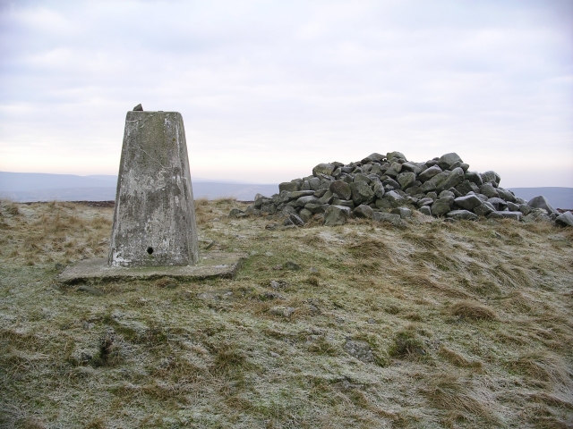
GW/SW-036 Mynydd Sylen


The first thing we saw when we parked at the end of the track for SW-036 was this Red Kite circling overhead...

This was almost a "drive on" summit - after just 200m along a public footpath you are at the trig point. The parking place is comfortably within the 25m activation zone, but we chose to operate from the trig point.  There were some commercial radio masts nearby but there was no interference on 2m FM. 
Geoff 2W0NON logging the first of six QSOs made from Mynydd Sylen
From Mynydd Sylen we made our first summit to summit contact of the day with Pete, GW4ISJ who was on a summit we visited the previous day - SW-012 Coity Mountain.  The nearest village to Mynydd Sylen is Llannon. 

GW/SW-039 Mynydd Llangyndeyrn

After driving through the village of Pontyberem just 20 minutes after leaving SW-036 we were walking the short distance across access land to reach the trig point on SW-039.


It was fun clambering over the rocky outcrop which leads to a burial chamber, but the clambering was unnecessary we realised when we reached the trig point, so on our return we took the easy path below the outcrop. Mynydd Llangyndeyrn is a significant historical site where there is a burial chamber. 

Mynydd Llangyndeyrn - a better site on VHF with nine stations logged on 2m FM
Pete GW4ISJ/P was still on Coity Mountain SW-012, so he got two summit to summit contacts for the price of one. We also logged Peter G3TJE/P on Dunkery Beacon SC-001 before leaving. 

GW/SW-038 Mynydd Drumau 

With two summits left on today's list yet to visit. it was now early afternoon, so after consuming our Ginsters Pasties we retreated back towards our hotel in Nottage, Porthcawl.

North of the industrial town of Neath lies the summit of Mynydd Drumau, which is reached along a track which turns left off the C class road at SS 738998 when coming from the south as we were. The bridleway is tarmac for the most part. Dyffryn Farm looked like it was an ecological power station, burning waste materials. 

Just six contacts made on 2m FM from Mynydd Drumau which is 272m above sea level
We continued driving on past Dyffryn Farm to park at the side of the track when it became rather rough at SS 729002. From there it took us 15 minutes to walk up to the trig point... just one easy fence to climb.

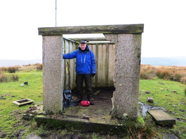
GW/SW-021 Mynydd Marchywel

After passing through the village of Bryn Coch we turned left up a farm road to reach grid reference SN 756014 where we parked on a right hand bend by a gate. The route had been suggested by someone we knew who had good local knowledge (thanks Mal!), on what is probably the most difficult to access SOTA summit in South Wales. 

It took me 48 minutes to walk the 1.75 miles to the trig point which is located in woodland. As I often find on trips like this, by day 3 I become tired and lacking in energy towards the end of the day. I hadn't eaten enough at lunchtime that day and I think that was my problem. It really was a struggle lifting my legs now trying to keep up with Geoff on our way to the summit. He is 8 years my senior!
Looking tired and drawn at the trig point on SW-021 Mynydd Marchywell
We entered the woodland at SN 7676 0350 and a clear path led through the forest to the hidden trig point.  Again we found the contacts needed to qualify with six contacts. The five amp LiPo battery I had been using all day ran out on this summit. After running the FT-1500M at full power (40 watts RF output) on the previous five summits, I was most impressed. The spare battery was pressed into service for the last five QSOs of the day. 

36 contacts were logged on Day Three of  our South Walian Tour
After consuming an energy bar and some coca cola on the summit I made it back to the car with renewed vigour, and we returned to our hotel in Nottage, Porthcawl for the night. Six more SOTA Completes in the bag. 

Tuesday, 20 January 2015

South Wales 2m FM Tour January 2015 - Day 4

SW-040  >  SW-032  >  SW-017

GW/SW-040 Mynydd Dinas

Our last day in Wales... We left Porthcawl 8.15am to activate the summit nearest to the town. This was Mynydd Dinas which overlooks the M4 Motorway south of Baglan. 


It took us 32 minutes to reach the summit trig point, mainly on a graded forestry track. It was fairly early and there were few stations listening, however we made contact with the necessary four stations before returning to the car (22 minutes). 
On Mynydd Dinas GW/SW-040 
We parked on a wide verge by the farm at SS 759926 where we walked to reach the summit on the Wales Coast Way upper link section.

GW/SW-032 Mynydd Allt-y-grug

Moving north we left the M4 motorway at junction 45 to bypass Pontardawe on the A4067. We turned off at the roundabout near Ynysmeudwy where the summit of interest could be clearly seen above the valley. A C Class road took us to a parking place at SN 742073.
Parking place for GW/SW-032
From here we walked back up to road to join a woodland footpath which led us to the moorland at a broken down fence at SN 745076:


We set up the station by some large stones just off the highest point of the moor - wild horses couldn't stop us...

Only six stations were worked and we packed up after ten minutes. As you can see from the map trace we strayed off course a little on our way down. The up route is the one I would recommend...

GW/SW-017 Hirfynydd 

Our last summit of the tour was reached from the street village of Banwen, which lies close to opencast coal workings and a wind farm.
Parking in the village street in Banwen
You don't see much of the open cast work going on as it is well screened off with pine woodland, however we could hear heavy machinery working as we walked the 2.3 miles to the summit. The Ordnance Survey map gave us no clue either that the area leading to and around the summit is a manufactured motorsport venue, predominantly I understand for rallying. This is definitely a summit we would not be revisiting, but a single unique visit was of course essential. 


We finished our activation in South Wales in the rain, we'd started in snow on day one but all in all we were delighted to complete 16 activations in the four days and we would be returning later in 2015 to do some more...
The contacts logged for SOTA on our final day in South Wales

Thursday, 8 January 2015

Black Mount GM/SS-158 & Broomy Law GM/SS-209

Another day in the Scottish Borders on our short break in January 2015....it was pretty cool, but dry by the afternoon. We went into Lanark for a look around and a nice lunch in a cafe down a side street. That was after being caught in a heavy shower of sleet.

A pound shop was visited and we bought an extraordinary amount of items for around £14. Arriving back at the hotel by around 2.30pm gave me chance to consider an activation on one of the local hills, so I set off to Black Mount SS-158, six miles from the hotel, for some winter bonus points. 

Parking place for Black Mount GM/SS-158
There is room to park at the side of the yellow road shown on the OS Explorer map at NT 074470.


A track led me up a cleft running along the south side of Newholm Hill.  Just as it got a little steeper I struck out to the right on to the rough moorland. Time to reach the summit from the car was 42 minutes up and 24 minutes down. For such a difference in time up and down I guess I found the climb quite a hard one, there is not usually such a marked difference between up and down as I am not a fast descender... 

Black Mount has the most eroded trig point I have ever seen. The years have weakened it around the base as you can see from this picture. I arrived just before 3.30pm and a sleet shower from around lunchtime was still lying on the ground. It was cold...


The number of stations calling me on the 40m band (42 in total) kept me going for 40 minutes, with the first contact being Nick G4OOE in Scarborough. 

From the summit I was focussing down below me to Broomy Law, GM/SS-209, which I was hoping to activate next, providing I could find my way up to it as it would soon be dark.

Broomy Law - seen from Black Mount - 3.2 Km away
It would have been good to try the 20m band out to see if I could work some DX outside of Europe, but as I wanted to garner another SOTA Complete in the day I shut down my station and left the summit just before 4.30pm to go to Brownbank Farm, a place where I believed I could reach Broomy Law from...

Broomy Law GM/SS-209

It was pitch dark when I arrived in the farmyard of Brownbank Farm near Biggar. I parked adjacent to some cow barns. There was no sign off human life, just the sound of cattle in the barns. I couldn't see the farm house from where I parked. If it had been daylight I would have asked permission to park, however on this occasion I felt that disturbing the farmer when he was probably eating his dinner was unwise. After hanging about for 10 minutes and with no one appearing to establish why I was parked in the yard I locked my car and set off up the well used track to the summit. It was 5.22 pm and I reached the communications compounds on the summit in 20 minutes. 


I really struggled to make any contacts on the summit at all - in the end I made 15 and it was my own fault for setting next to a communications cabin to shelter from the bitter wind:


On switching on the radio it reset itself to the "factory default". This meant the keyer was switched off for a start. Then I realised that several of the controls were inoperable. This had happened to me once before when I was operating from a German summit in 2014, with the same transceiver a Yaesu FT-857. 

Pole lashed to corner post next to comms cabin - no wonder immunity to nearby RF fields was poor!
By disconnecting the antenna and altering several menu settings I was able regain control of the radio and transmit on 40m SSB. My self spot using (Rucksack Radio Tool by DL1DLF) raised Rod M0JLA in Hereford followed by Chris ON6ZQ, who I was to meet a few months later on a summit in Belgium. I wasn't able to operate the radio on 20m at all, but I did get the radio to operate in CW and I made some contacts on 40m and 30m. Best DX was with CT9/G8DX who is Jack. Not a SOTA guy but a DX chap I met in 2014 when I was at Ham Radio in Friedrichshafen. I heard Jack calling CQ and called him, so I got my QSO that way. After 20 minutes fiddling around I gave up and shut down. Here is my complete log:


When I got back to the hotel I tried the radio out again and there was no problem, everything worked. The experience told me when possible, to set up away from any other communications installations!

Tuesday, 6 January 2015

Cairnpapple Hill GM/SS-254 January 2015

We were on a short break in the Scottish Borders staying in a country hotel near Biggar. A day was planned to look around Edinburgh. So we drove north through unfamiliar territory until we reached the outskirts of Bathgate. Just north of the town is the Marilyn summit of Cairnpapple Hill GM/SS-254.

Hole in the trig just deep enough to take the pole at an angle.... comms station to the north
A hill called the Knock is probably better known locally - due to its pointy prominence, history and topograph, but it isn't as high as our hill. I measured the col on the tarmac road between the two hills and it came out just a tad over 25m, so the trig point is the place to operate from, as stated on the SOTA Summits page, not The Knock.

There is a rough car park below The Knock. A metal gate on the left side of the road just north of the road junction shown on the OS map needs to be climbed and you are at the trig point within 10 minutes of locking up the car. 

48 QSOs completed from the summit, but only one on 2m FM with Jack GM4COX
I was on the air for 40 minutes on 7 MHz CW/SSB & 14 MHz CW. Best DX was CU3AA Joao in The Azores. 

I packed up and off we went to Edinburgh for the rest of the day...

Monday, 5 January 2015

Goseland Hill GM/SS-203 January 2015

A Hotel in Scotland is an expensive place to be over New Year, but just after that you can get a short break at a bargain price via Travelzoo and this my XYL Judy and I did in January 2015, when we stayed at a Hotel near Biggar in the Borders that looked a little like a Castle:

Shieldhill Castle Hotel
I get tired of hearing about all the places that Oliver Cromwell slept. Well he didn't stay at Shieldhill, but Nelson Mandella did in 1997 when he was attending the Commonwealth Conference that year in Edinburgh. We saw the now maturing tree he planted in the garden. The great man, who by 1997 was the master of his jailers, may have slept in the same room as we did for the four nights we were there - fine business!

It's hard to get Judy to sit on a summit for upwards of an hour in the UK winter so I was on my own for the four HF activations I planned to do on this short holiday which included day trips into Lanark, Glasgow and Edinburgh

Goseland Hill GM/SS-203

Click to get full size map
After checking in on our arrival day I left at 3.15pm local time to go to Goseland Hill which is less than 6 miles south east of the hotel. I located a small worked out quarry and parked here (NT 072344). It took less than 20 minutes to reach the trig point in failing light. I was walking over rough moorland, my route down one hour later following a quad track in the dark, was much easier walking, so if you visit this summit take note. As I approached the lights of the farm Gosland in the dark on my way down I took a swerve due to a barking dog there that was piercing the still night air. 

As the light went Goseland Hill felt a lonely place to be...
Transceiver: FT-857 50 watts output, Palm Key
Antenna: 40m Dipole on 6m pole
Contacts made: 32 (10 EU Countries) in 25 minutes CW - SSB

Wednesday, 31 December 2014

G4OBKs Summit On The Air (SOTA) Review of the year

Another year over and a new one just begun...so the festive song goes.... 

(G4OBK Left) Operating from a summit in Mid Wales in August 2014 (2E0NON Right)
2014 was the ninth year in which I have been taking part in Summits On The Air (SOTA), an idea which John Linford G3WGV and Richard Newstead G3CWI spawned in 2002. 

SOTA is a branch of ham radio that has grown into one of the biggest amateur radio award programmes in the world.

The attraction (Some call it "SOTA Fever") is that the scheme combines so many things I enjoy about life... Getting out into the great outdoors, keeping healthy through exercise and enjoying operating amateur radio equipment using Morse Code and Voice and Data Communications, at home and on the tops of hills. Add to that some international travel, meeting people on the air and in person from all over the world sharing a common interest. SOTA is also mildly competitive with league tables for different aspects of SOTA. 

As someone who makes contacts with station on hills and mountains from the comfort of my home radio shack I am a Chaser. I also like fellwalking and being outside so I am also one who operates from the hills and mountains - an Activator. 

Being both an Activator and a Chaser makes me a "SOTA Completer". This is the SOTA award which I am the most interested in.

SOTA Complete started in 2012, ten years after the start of SOTA. In 2014 I achieved the 250 points target - this means I have had contacts from 250 summits and I have made contact from home as a chaser with the same 250 summits. I went on in the course of the year to complete 285 summits.  This places me in the UK Complete Table in 7th position out of 318 listed stations. 

The top 15 UK Stations doing SOTA Complete 4th January 2015

2014 was my most active year since I started taking part in SOTA in 2005:

2014 Chaser Points claimed:  18399 (2013 = 10068)

2014 Activator Points claimed:   350 (2013 = 168)

2014 SOTA Complete Points claimed:  76 (2013 = 67)

2014 SOTA Country Associations Activated: 10 (2013 = 3)

2014 Number of SOTA Activations: 94 (2013 = 81)

Position in all UK SOTA Complete Table 2014 = 7th (318 entrants)

Position in Worldwide SOTA Complete Table 2014 = 10th (1199 entrants)

Position in all UK Chaser Table = 2nd (947 entrants)


Position in all UK Activator Table = 17th (835 entrants)


Position in all UK Chaser Unique Table = 2nd (868 entrants)

Position in all UK Activator Unique Table = 14th (635 entrants) 


So as I look forward to another year in SOTA. I will celebrate my 10th anniversary chaser contact on March 3rd, and my 10th anniversary activation, the first of which was in Scotland, on June 21st 2015. 

Thursday, 11 December 2014

The South Central summits of Exmoor - Periton, Dunkery and Selworthy

With more time available the three summits of G/SC-001 Dunkery Beacon, G/SC-005 Selworthy Beacon and G/SC-006 Periton Hill could well form the basis of a moderate two day expedition from Minehead of around 17 miles, or a one day challenge of the same distance. The total ascent of a typical route would be less than 4000 feet. I say typical route, as there are so many accessible and well maintained public rights of way crossing the area, which would make this a superb itinerary. 

However, due to the lack of time we used a car to get between summits, so the total distance walked was a shade over 5 miles with 850 feet of ascent... We drove down to the area from Bristol where I was staying for a few days, with Geoff 2E0NON picking me up en-route from his home near Malvern. We met up at the Cribbs Cross Shopping Park at junction 17 just off the M5 north of Bristol at 7.15am. Leaving Geoff with a 90 minute drive to the car park serving our first summit at Periton Hill. The weather was blustery, with frequent showers and hail on and off throughout the day. Operation on HF would have proved difficult, and I was carrying my golf brolly to at least protect the small VHF mobile radio from water damage...

Equipment for the day:

Yaesu FT-1500M 145 MHz FM Transceiver with 40 watts output with two 5 AH LiPO batteries

Short 3.5m fishing pole supporting a half wave end fed vertical dipole

G/SC-006 Periton Hill  QRV 0953z - 1007z 145.300 FM

Our track taken from a Garmin GPS62s unit
The writer at the trig point on Periton Hill
All three summits from the most convenient parking areas could be deemed "easy". For Periton Hill we parked at the top of the tarmac road in an area well used by dog walkers and outdoor types SS 963447. A 30 minute walk on good tracks of less than 1.5 miles took us to the trig point which seemed the most convenient point on which to set up our 145 MHz half wave end fed dipole at 12 feet AGL. Looking north towards Wales, where we thought our likely contacts would come from, appeared to be obscured by the ridge across Selworthy Beacon (308m). This was only a shade higher than where we were set up at 295m. This distant ridge wasn't a problem however and contacts were made into Wales. Vodafone coverage from the Periton Hill area was flakey, as it was on all three summits, but somehow self spots were generated using the RRT App and we scaped by with just five contacts. 

Geoff Fielding 2E0NON marching off the summit of Periton Hill G/SC-006
We returned by car to the A39 and turned left to head for our second summit of Dunkery Beacon to collect our first winter bonus points of the 2014/2015 winter...

G/SC-001 Dunkery Beacon (Somerset County Top) QRV 1152z - 1201z

Topographic trig pillar (also antenna support)
From the roadside parking spot at SS 904420 we could see the large permanent feature of a concreted cairn (built in 1935) on the summit of Dunkery Beacon, just short of one mile away. We used the Macmillan Way LDP to get there in less than 20 minutes. The rain was holding off when we arrived and we snuggled behind the topographic trig point for shelter. The panorama over Exmoor and to the Bristol Channel and all around was superb and we could watch the weather coming in, which indeed it did towards the end of our short activation.

The writer at Dunkery Beacon, Marilyn Summit and Somerset County Top
Don G0RQL (Holsworthy) was the first station worked of six, Don is a good friend and regular SOTA enthusiast who I often hear and indeed work on HF SSB from my home station in North Yorkshire. We were soon back at the car for a bite to eat before heading down into Minehead on our way to the third summit of the day Selworthy Beacon. 

G/SC-005 Selworthy Beacon QRV 1328z - 1343z

Geoff parked his Subaru by the track leading up to Selworthy Beacon
The appropriately named Hill Road took us over North Hill west of Minehead to the parking place for Selworthy Beacon. We pulled up at SS 92304788 and parked alongside the track. The walk to the summit took less than five minutes, and we set up behind some thick gorse bushes deploying the golf brolly, which was guyed down. This provided sufficent protection for the radio from the rain and hailstones...

Geoff 2E0NON working Phil GW0IRT in Ebbw Vale - the only station we worked on all 3 summits!
New Look Eatery

With another five stations logged we left the summit and made our way back to the M5 at Bridgwater. On the way there we stopped off at Blackmore Farm Shop Cafe just before Cannington for this.. a cream tea...you can't get cream like this in Yorkshire, fantastic, thick, and produced by hand - recommended!

The day's "catch" worked by G4OBK and 2E0NON
So that is it for me in 2014, no SOTA Activating now for me until January when we head for South Wales to conquer a few more Marilyns for Summits On The Air... I've had a good year in SOTA with portable operation from 10 Countries with 77 SOTA Completes done and 350 Activator Points earned.

Thursday, 6 November 2014

A one day foray into Scotland with Dave G(M)3TQQ and Geoff 2(M)0NON...

In early November I organised a holiday for 22 members of our walking club.  We stayed in a hotel at Alnmouth in Northumberland for three nights. 

Organising these trips has been something I have done since 2007 and it gives me great satisfaction. I usually build in some Summits On The Air (SOTA) activity as part of the holiday and this trip was no exception. The previous day I had visited G/SB-007 Tosson HIll and completed just the one contact with Derek G1ZJQ in Cramlington using my small Yaesu VX-170 Transceiver - distance 21 miles with rubber duck antenna which was pretty good DX to my mind... As I was concentrating on leading Ryedale Walking Group that day on a fairly challenging walk across the Simonside Hills, I was happy with that. Up ahead of me though, my three compatriots Dave, Geoff and Nick (G4OOE) had already activated the summit by walking ahead of the group to give them more time to set up their station on HF and VHF. 

Climbing Simonside on our way to G/SB-007 Tosson Hill the previous day
Back to today then, which was classed as a "free day" for the walking group to do as they pleased, without a led walk.... this for us meant we were able to execute the plan to drive up to North Berwick Law (GM/SS-280) calling in at Lamberton Hill (GM/SS-286) on the way. For the run south back to Alnmouth in the afternoon, we went inland to visit the remote summit of Spartleton - GM/SS-182.  The writer Phil GM4OBK, was the navigator for the day, Dave GM3TQQ was the driver in his Land Rover Freelander, and Geoff 2M0NON was riding shotgun in the back. We left the hotel before breakfast at 6.30am to head for the border at Berwick on Tweed...

The plan was to activate on high power using FM on 145 MHz from a Yaesu FT-1500M and use around 30 watts from my Yaesu FT-857 on 7 MHz CW and SSB. We found that contacts on the 2m band were hard to come by, which was not unexpected going by our previous visits. 

GM/SS-286 Lamberton Hill QRV 0814z - 0845z 40m CW/SSB & 2m FM

Geoff left and Dave G(M)3TQQ leaving the summit earthworks - happy after his first HF SOTA activation
A short walk from the roadside at NT 946589 took us to the gate at NT 947588 and after a short climb we were amongst the earthwork of Habchester Fort, choosing a fence line where we could fix our fishing poles. My first contact on 40m CW was with Mariusz SP9AMH, no problems. After the small pile up died away I retuned the rig to 40m SSB, made one contact with John G0TDM, and then passed over the station to Geoff and Dave to qualify the summit in their own right.  

I then went on to the 2m FM band to complete two contacts with stations near to Dundee.  

Bacon Butties and Tea on the A1 near Torness Nuclear Power Station en-route to North Berwick Law...living large
I think we were successful in getting plucky Yorkshireman Dave G(M)3TQQ to catch the activation variant of SOTA Fever - the only cure for it being old age and/or failing knees and lung power. This was Dave's first SOTA Activation in the company of others and on HF. In his favour he is a keen regular hillwalker so I think he will be with us in SOTA for many a year yet....
As we ate our breakfast by the van the grey day turned into a wet scotch misty one...suffering it was to come...

GM/SS-280 North Berwick Law QRV 1111z-1131z 40m CW/SSB & 2m FM

This, the shortest and slippiest route was not one that I would recommend again in the wet and slippy conditions we had that day, however we did it and in doing so I fell into the wet clay mud on the way down....

This was a route I got from another Yorkshireman Terry G(M)0VWP (You meet the odd good Yorkshireman) who went that way during the summer:


We parked up in a communal parking area at Heugh and then followed a waymarked and steep route to the summit. Its conical shape is really prominent lying within 1 Km of the seashore - it is very unusual indeed. It took less than 15 minutes to reach the top where there was a whale bone archway piece of artwork, and a roofless ruin where we set up our two stations in the rain.

Geoff 2(M)0NON arriving at the Whale Bone Arch on North Berwick Law
The golf umbrella was deployed to save the FT-857 from getting damaged. The 2m FM station proved dissapointing, with Geoff and Dave realising just one contact with MA6BJJ in Dundee. 40m CW gave me 17 contacts in 15 minutes with Belgian, Swiss, Swedish, German and UK stations though before I handed over the station to the SSB guys who made 8 UK contacts each on 40m SSB.

Thumbs up from Dave - the summit was qualified despite the bad audio caused by an under-voltage battery
Not long after they started on single sideband my newly puchased Tracer 8Ah Lithium battery started to go under voltage and we received some reports of very distorted audio...the jury is still out on if this battery if up to the job... more tests are needed, but it was on its second summit at 50 watts after all, and I suspected that it may not have been fully charged when we started the day. 

Operation was adjacent to the wall of the ruin to keep the rain off the radio equipment
Whilst my two cohorts continued operating in the rain on 40m SSB I had a walk around the summit, finding an air raid shelter / Observation Post with an open front which was well within the 25m drop activation zone. I only wished we had seen the structure on our arrival and we would have set up there in the dry - lesson learned - either do a thorough site survey on arrival or check out Geograph in advance of every summit you visit!  

Observation Post on North Berwick Law dating back to World War II
Heading back down the very steep slippery hill I went base over apex, no injury, just dirty clothing. We were well soaked when we got back to the car. From North Berwick we went back down south and further inland to our 3rd and final (and higher) summit of the day - Spartleton GM/SS-182...

GM/SS-182 Spartleton QRV 1420z - 1453z 40m CW/SSB

GPS Track to Spartleton - 6th November 2014
It took around 45 minutes to drive from North Berwick Law to Spartleton. The moorland road took us up over 1100 feet past the remains of White Castle Fort. We parked Dave's motor on the B6355 at the side of Whiteadder Reservoir at the gate at the start of the walk up to Spartleton (Grid Ref NT 649641). We took time out to eat our lunch before setting out, I'm afraid I have no photos of our trek and the top, this was due to the weather - we had strong winds, mist and rain, photography was out as it was a major exercise just to get there and set up for the activation. The 40 minute walk up was pleasant though, on quad tracks and a little rough ground, with one gully to descend into and out of when we crossed Hill Burn, an appropriate name, but how many of those are there in Scotland?  We suffered when we reached the summit where the conditions worsened as the three of us huddled behind the trig and pile of stones. A large stone was used to help "keep" the 6m long fishing pole hard against the trig point to which it was tied. This crushed the pole but fortunately not too badly and it was repaired with large bore shrink sleeving once I returned home.

Summit, Sparleton
Spartelton from Geograph under CCL by Chris Ellbeck - picture taken when there was visibility
We didn't bother even trying VHF on this final activation and thankfully we had no radio reports of distorted audio which we had from North Berwick Law - using a fresh battery did the trick and the Yaesu FT-857 was undamaged, and so we made plenty of QSOs on 40m (7 MHz short wave) in Morse and Phone before packing up and heading back down. 

Dave had over a 90 minute drive now back to Alnmouth. The Satnav took us via Duns and we joined the A1 near Berwick on Tweed. It was dark by then but we reached our hotel in good time for dinner where we were reunited with our friends in Ryedale Walking Group, most of whom had been on a coastal walk near Craster, led by my friend Owen Turnbull. Needless to say, they had enjoyed better weather than we had experienced...but once again it was "Mission Accomplished" for Summits On The Air !